Snow Developing Later This Afternoon
Snow Developing Later This Afternoon
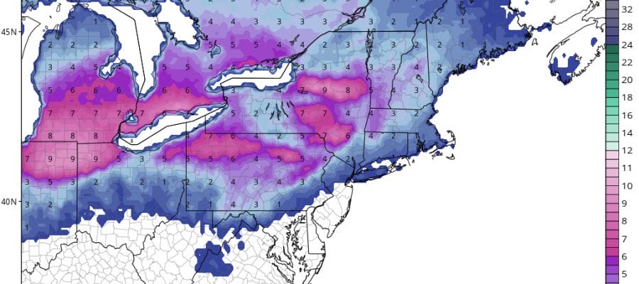
We are seeing snow already showing up on the radar this morning in parts of Southeastern Pennsylvania. Much of this is on the light side. This is the warm front setting up for later this afternoon and tonight. Look for clouds to thicken up with snow developing from west to east late today. This will not be an even distribution of the snow in terms of coverage. In other words there will be gaps where some folks see more and some see less. The main action in my view will be north of route 195 and particularly north of route 78 in New Jersey. Snow this evening will begin to change over to rain in the late evening along the immediate coast but it could snow into the early morning hours in Northwest New Jersey, the Hudson Valley and Connecticut.
Snow Developing Later This Afternoon Radar Loops


Most area up to Route 84 will wind up changing to rain by morning. The rain will end by midday Monday. There are no changes in my forecast for total snow amounts.

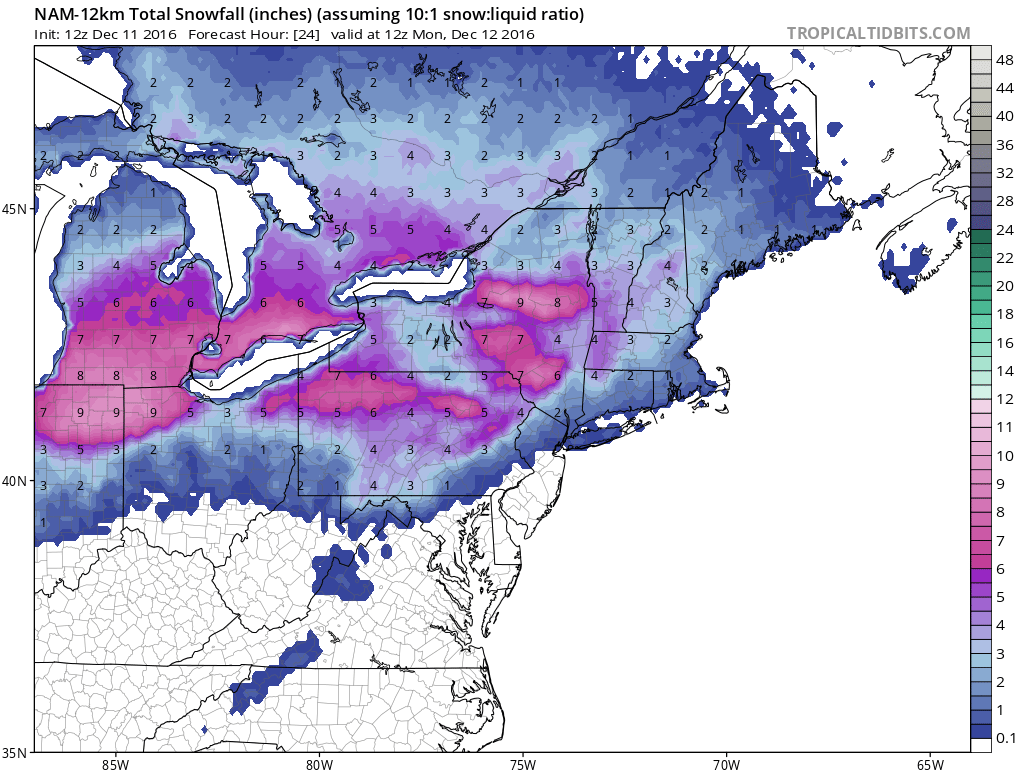
Here is the latest Nam snowfall forecast map. I think it supports leaving my forecast exactly the way it is.
Later this week bitter cold air will be coming southward into the Northeast and it will be the coldest weather we have seen at this time of month of December in quite a long time. We will see a day late this week where temperatures don’t get out of the 20s and nights will be in the teens and single digits. Next weekend sees the prospect of snow ice and/or rain and we will have more on this later today.
SNOW REMOVAL COMPANIES FOR YOUR WINTER NEEDS
LONG ISLAND ROCKLAND COUNTY Connecticut

![]()

FiOS1 News Weather Forecast For Long Island
FiOS1 News Weather Forecast For New Jersey
FiOS1 News Weather Forecast For Hudson Valley
NATIONAL WEATHER SERVICE SNOW FORECASTS
LATEST JOESTRADAMUS ON THE LONG RANGE
Weather App

Don’t be without Meteorologist Joe Cioffi’s weather app. It is really a meteorologist app because you get my forecasts and my analysis and not some automated computer generated forecast based on the GFS model. This is why your app forecast changes every 6 hours. It is model driven with no human input at all. It gives you an icon, a temperature and no insight whatsoever.
It is a complete weather app to suit your forecast needs. All the weather information you need is right on your phone. Android or I-phone, use it to keep track of all the latest weather information and forecasts. This weather app is also free of advertising so you don’t have to worry about security issues with your device. An accurate forecast and no worries that your device is being compromised.
Use it in conjunction with my website and my facebook and twitter and you have complete weather coverage of all the latest weather and the long range outlook. The website has been redone and upgraded. Its easy to use and everything is archived so you can see how well Joe does or doesn’t do when it comes to forecasts and outlooks.
Just click on the google play button or the apple store button on the sidebar for my app which is on My Weather Concierge. Download the app for free. Subscribe to my forecasts on an ad free environment for just 99 cents a month.
Get my forecasts in the palm of your hand for less than the cost of a cup of Joe!


