Snow Arrives Tonight Winter Weather Advisory
Snow Arrives Tonight Winter Weather Advisory
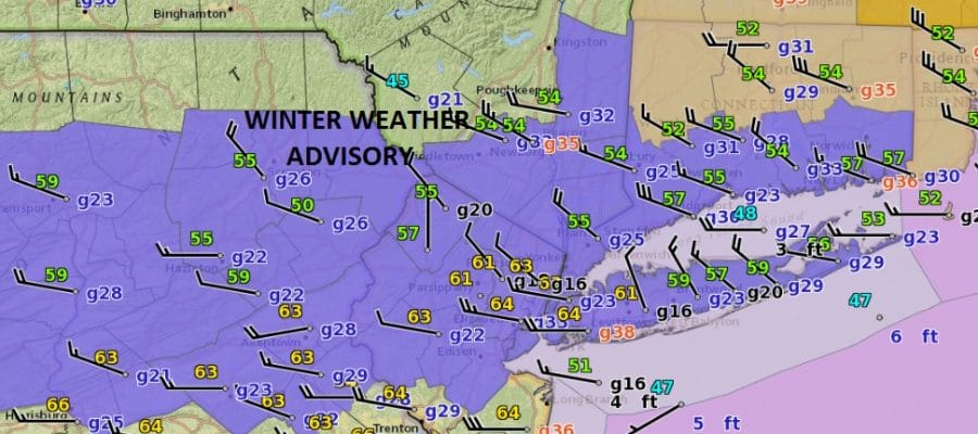
Winter Weather Advisory is posted for most of Northeastern Pennsylvania, the Northern Half of New Jersey, New York City, Long Island and most of Connecticut. Honestly I’m having a very tough time with this because of the critical nature of the temperatures tomorrow and trying to figure out whether snow will accumulate on roads to any extent. Intensity of snow is key so I’m thinking that snow accumulations will favor grassy surfaces more than roadways and that travelling tomorrow may not be that bad. However the final verdict on this won’t be out until the snow actually starts falling so at this point we will just let things roll.
JOE’S SNOW FORECAST
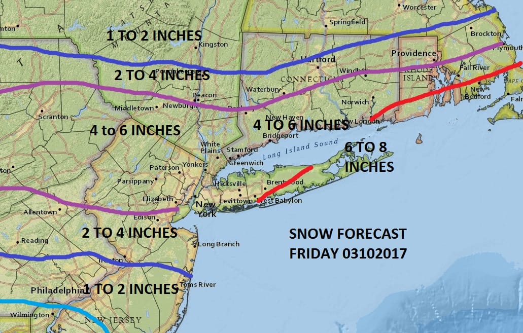
Even though many of the weather models match up well with my snow forecast some do not and have lower amounts. This would be simpler if temperatures were 5 degrees colder than are now currently forecast. We will probably be in the 31-34 degree range throughout much of this event and anything that falls during the day tomorrow I believe will stick to colder surfaces. The key will be what happens between 4am and 8am. Snow will start around 3 or 4 am so what falls in those first 4 hours will probably stick on most surfaces before the sun angle takes its toll later in the morning. Snow should end in the early afternoon. Another burst of snow is possible late in the afternoon as the arctic boundary passes and that could white up the ground again in spots as temperatures fall.
SATELLITE LOOP

We are beginning to see clouds streaking across the Midwest on the satellite loop. There isn’t much going on radar wise and this will all literally develop right overhead tomorrow morning. It will remain dry with increasing clouds tonight and temperatures will be dropping to the low and mid 30s by 7am.
REGIONAL RADAR

LOCAL RADAR NEW YORK CITY

LOCAL RADAR PHILADELPHIA


As far as the weekend is concerned, it will be very cold with ineffective sunshine both Saturday and Sunday with highs just in the 20s to some lower 30s. Another storm could threaten with snow on Tuesday as a storm comes out of the Gulf of Mexico and heads up the east coast. We will discuss this system further later today.
 GET JOE A CIGAR IF YOU LIKE

SNOW REMOVAL COMPANIES FOR YOUR WINTER NEEDS
LONG ISLAND ROCKLAND COUNTY Connecticut

![]()

ROCKLAND COUNTY TRI STATE SNOW REMOVAL JOHNSTOWN PA


FiOS1 News Weather Forecast For Long Island
FiOS1 News Weather Forecast For New Jersey
FiOS1 News Weather Forecast For Hudson Valley
NATIONAL WEATHER SERVICE SNOW FORECASTS
LATEST JOESTRADAMUS ON THE LONG RANGE
Weather App

Don’t be without Meteorologist Joe Cioffi’s weather app. It is really a meteorologist app because you get my forecasts and my analysis and not some automated computer generated forecast based on the GFS model. This is why your app forecast changes every 6 hours. It is model driven with no human input at all. It gives you an icon, a temperature and no insight whatsoever.
It is a complete weather app to suit your forecast needs. All the weather information you need is right on your phone. Android or I-phone, use it to keep track of all the latest weather information and forecasts. This weather app is also free of advertising so you don’t have to worry about security issues with your device. An accurate forecast and no worries that your device is being compromised.
Use it in conjunction with my website and my facebook and twitter and you have complete weather coverage of all the latest weather and the long range outlook. The website has been redone and upgraded. Its easy to use and everything is archived so you can see how well Joe does or doesn’t do when it comes to forecasts and outlooks.
Just click on the google play button or the apple store button on the sidebar for my app which is on My Weather Concierge. Download the app for free. Subscribe to my forecasts on an ad free environment for just 99 cents a month.
Get my forecasts in the palm of your hand for less than the cost of a cup of Joe!


