Weather Models Zeroing In On Early Next Week

Weather Models Zeroing In On Early Next Week
Over the last several days weather models have been zeroing in on the possibility of another snow threat early next week. Weather models are clearly now zeroing in on a storm developing off the Southeast Coast of the US and heading up the Eastern Seaboard. I think we are at the point now that we can say something is going to happen somewhere from Virginia to New England inclusive. The hows and whys are still in question.
GFS WEATHER MODEL MONDAY INTO WEDNESDAY
CLICK TO ANIMATE

The GFS weather model above has been remarkably consistent for the last 8 model runs. There has been a gradual shift to the left closer to the coast and this means that one at least has to consider the possibility of a coast hugger which would bring rain to coastal areas at some point. But why are models so consistent all of a sudden? Up until now we have been dealing with smaller systems that have been running around. Each has an impact on the other. However when the atmosphere is telegraphing a large system, there are fewer players on the table and therefore the options of different outcomes is reduced. Such is the case here.
GFS UPPER AIR FORECAST FOR TUESDAY
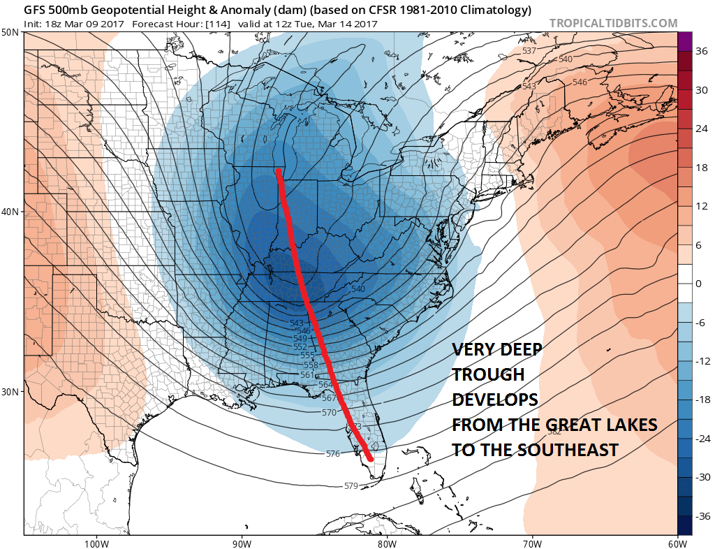
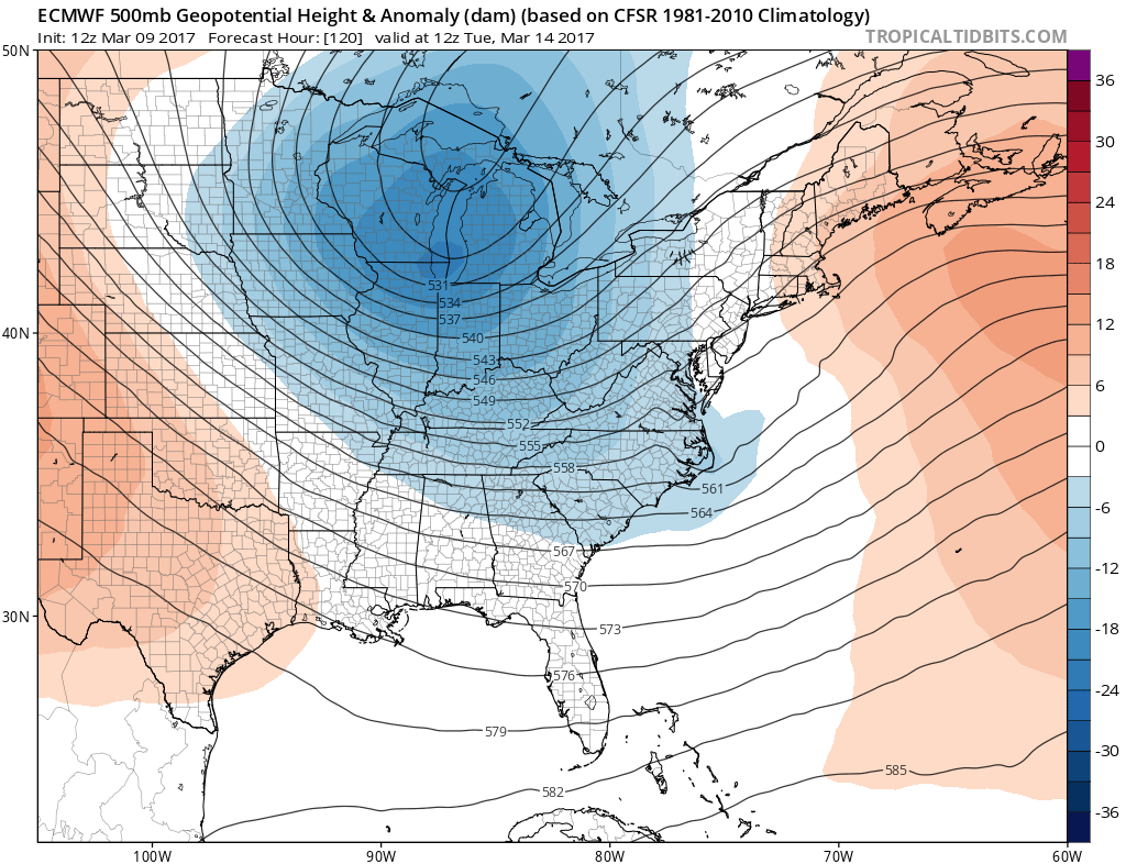
Now each model has this deep trough and each model handles things a little differently. The European model and the Canadian model are even deeper (more intense) with the upper feature than the GFS model
EUROPEAN WEATHER MODEL TUESDAY MARCH 14TH
CANADIAN MODEL FOR TUESDAY MARCH 14
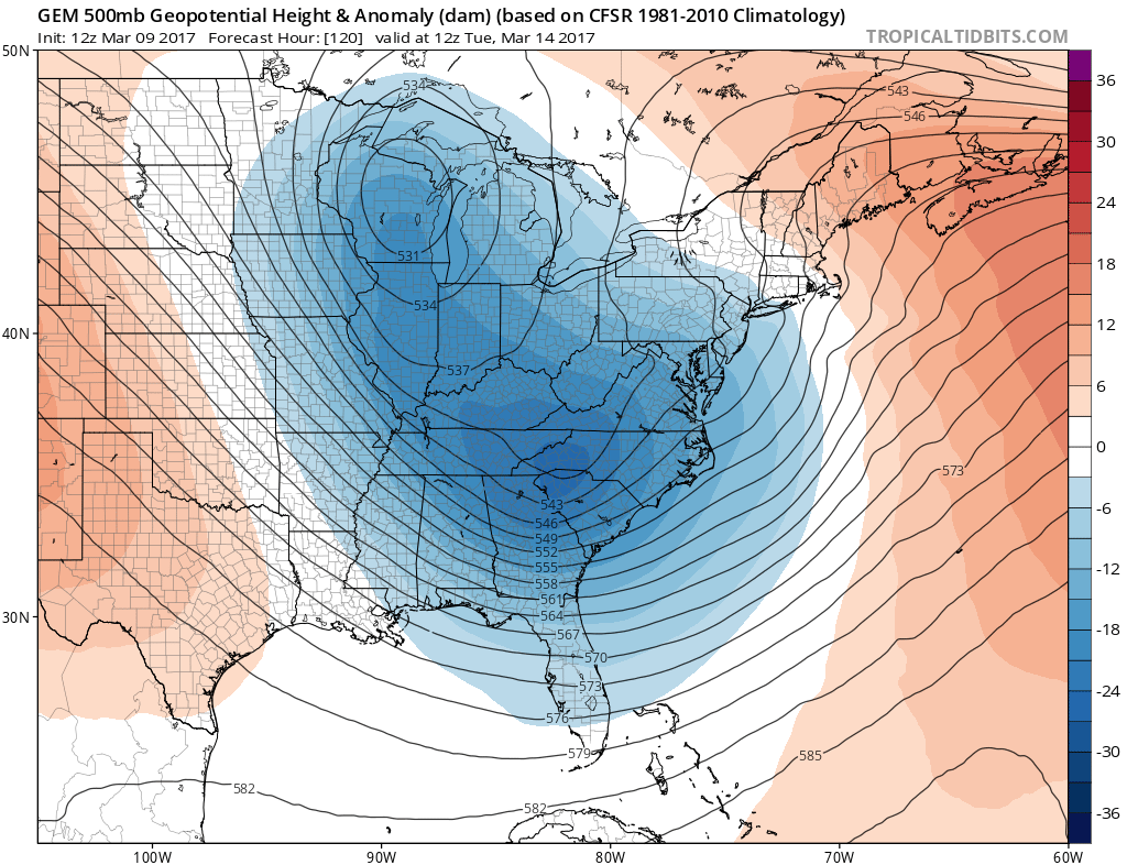
Both the Canadian model and the European model would imply a major upper air storm diving southeast toward the Middle Atlantic Coast. The result on their surface reflections show large storms just offshore.
CANADIAN WEATHER MODEL TUESDAY MARCH 14TH

EUROPEAN WEATHER MODEL TUESDAY MARCH 14TH

The Canadian weather model is the most intense with the surface low. The European gets there 12 hours later as it is a bit slower. The look on both the surface and aloft all suggest a major winter storm but remember track is key regarding what happens whether it be snow or snow with a change to rain. Given the structures of the upper air on all three models an out to sea solution seems to be remote.
EUROPEAN WEATHER MODEL WEDNESDAY MARCH 15
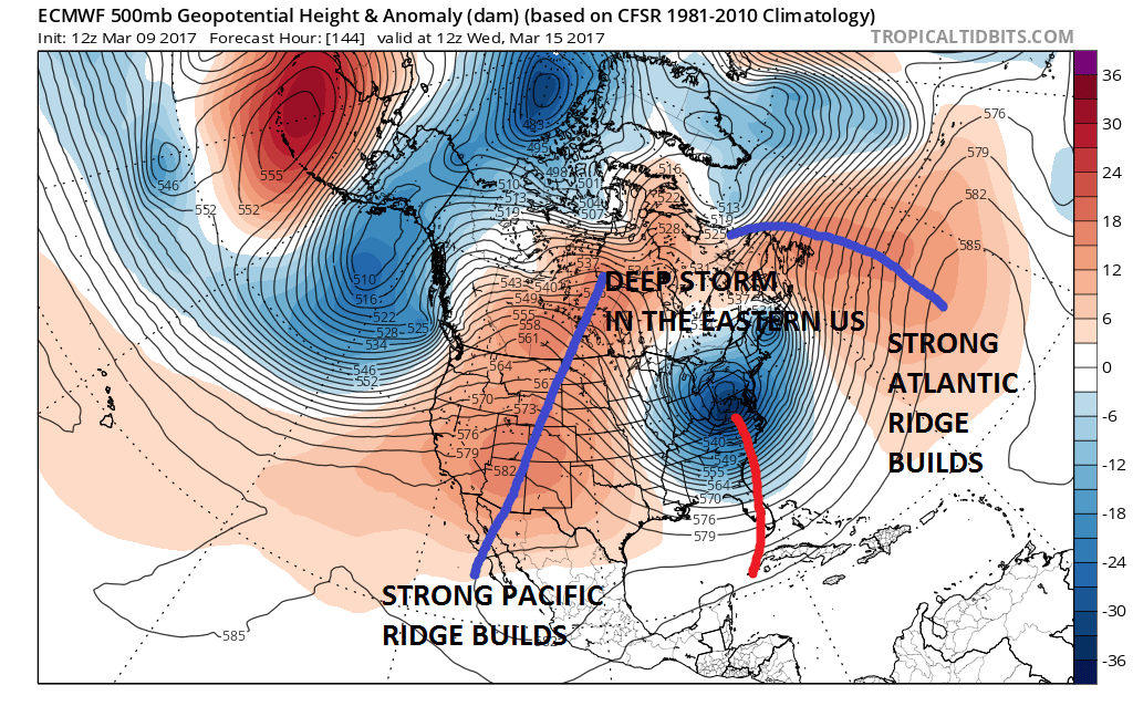
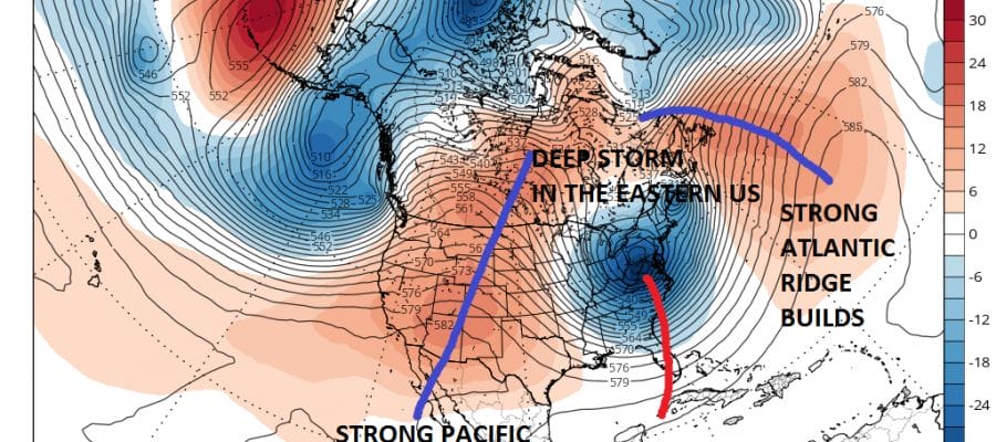
We think that with the presence of a strong ridge in the west building northeastward and a strong Atlantic Ridge building northwestward traps the upper air energy in between. What will impact track will be the dominance of either ridge. One being weaker would change track. A weaker Pacific ridge or Atlantic ridge would change the dynamics of the system. Right now it seems all the weather models are lined up together that both ridges will be strong.
The plan ahead is to see what the next 4 runs of models show us. If the consistency continues through Friday night then I think we may be in position to make an early call of some sort on Saturday. Until then we continue to watch how models evolve and progress over the course of the next 2 days.
Weather Models Zeroing In On Early Next Week
MANY THANKS TO TROPICAL TIDBITS FOR THE WONDERFUL USE OF THE MAPS

GET JOE A CIGAR IF YOU LIKE!
SNOW REMOVAL COMPANIES FOR YOUR WINTER NEEDS
LONG ISLAND ROCKLAND COUNTY Connecticut

![]()

ROCKLAND COUNTY TRI STATE SNOW REMOVAL JOHNSTOWN PA


FiOS1 News Weather Forecast For Long Island
FiOS1 News Weather Forecast For New Jersey
FiOS1 News Weather Forecast For Hudson Valley
NATIONAL WEATHER SERVICE SNOW FORECASTS
LATEST JOESTRADAMUS ON THE LONG RANGE
Weather App

Don’t be without Meteorologist Joe Cioffi’s weather app. It is really a meteorologist app because you get my forecasts and my analysis and not some automated computer generated forecast based on the GFS model. This is why your app forecast changes every 6 hours. It is model driven with no human input at all. It gives you an icon, a temperature and no insight whatsoever.
It is a complete weather app to suit your forecast needs. All the weather information you need is right on your phone. Android or I-phone, use it to keep track of all the latest weather information and forecasts. This weather app is also free of advertising so you don’t have to worry about security issues with your device. An accurate forecast and no worries that your device is being compromised.
Use it in conjunction with my website and my facebook and twitter and you have complete weather coverage of all the latest weather and the long range outlook. The website has been redone and upgraded. Its easy to use and everything is archived so you can see how well Joe does or doesn’t do when it comes to forecasts and outlooks.
Just click on the google play button or the apple store button on the sidebar for my app which is on My Weather Concierge. Download the app for free. Subscribe to my forecasts on an ad free environment for just 99 cents a month.
Get my forecasts in the palm of your hand for less than the cost of a cup of Joe!
![]()
