Smoke Continues to Plague Much of the Northeast & Mid Atlantic into Saturday

Smoke Continues to Plague Much of the Northeast & Mid Atlantic into Saturday

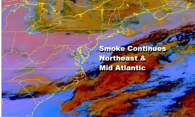
We continue to see areas of smoke covering the Great Lakes and Ohio Valley east to the Mid Atlantic and Northeast. The areas in pink in the picture above show the areas of dense smoke and these plumes of smoke continue to rotate southeastward on the backside of a stalled upper air storm over Northern New England. This storm system has not moved all week and until it gets out of the way, the smoke will continue to be an issue. That system finally moves out over the weekend and we should see far less of this smoke once the upper air winds shift from northwest to southwest.
In the meantime today we have an upper trough swinging around the upper low and that will move southeast today bringing clouds and the risk for some scattered showers and perhaps a thunderstorm or two. Yesterday’s smoke kept temperatures in many areas just in the 60s a that could very well happen today. The smoke is so thick at times that it blocks out the daytime heating. This could reduce the chances for thunderstorms today though it doesn’t completely take them off the table.
SATELLITE

WEATHER RADAR

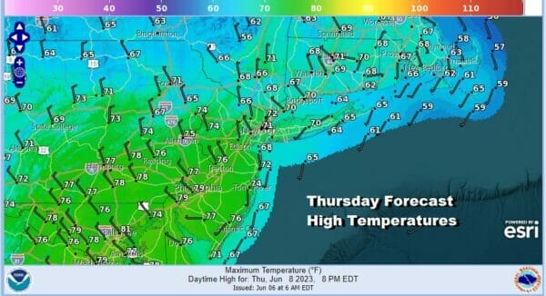
We will go with highs in the upper 60s to lower 70s today and we will keep an eye on the radars during day. Otherwise once we get into the evening hours we will see any showers disappear leaving us with leftover clouds alon with areas of smoke. Lows by morning will be in the upper 40s to mid 50s.

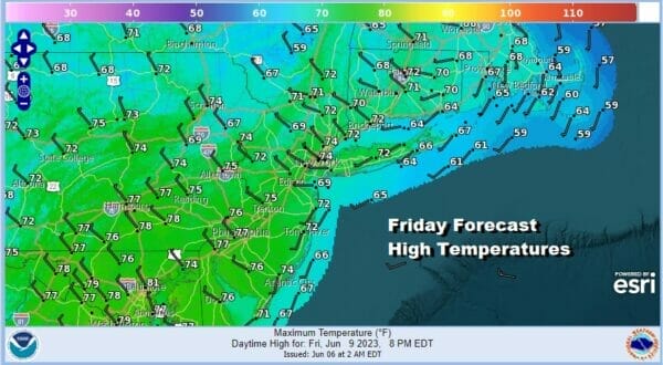
Another upper trough will swing around and move through Friday and with that we will see clouds around and the chance for scattered showers or a thunderstorm especially inland. Smoke again will be a variable to consider. Friday highs will be in the upper 60s and lower 70s. This by the way is about 10 degrees below average.
The weekend is looking ok overall though there stll may be smoke around Saturday however with the upper air storm in New England moving away to the east, there should be some improvement developing. We also will see some sunshine Saturday with most highs in the 70s. Sunday we finally get into a southwest flow in the upper atomosphere and that should finally cut off the upper air connection from Northern Canada. Sunday will be very warm with sunshine and highs will be in the 80s. No rain is forecast over the weekend but we do have a cold front that will approach Monday with the chance for showers and thunderstorms developing later in the day.
BE SURE TO DOWNLOAD THE FREE METEOROLOGIST JOE CIOFFI WEATHER APP &
ANGRY BEN’S FREE WEATHER APP “THE ANGRY WEATHERMAN!
MANY THANKS TO TROPICAL TIDBITS FOR THE USE OF MAPS
Please note that with regards to any severe weather, tropical storms, or hurricanes, should a storm be threatening, please consult your local National Weather Service office or your local government officials about what action you should be taking to protect life and property.
(Amazon is an affilate of Meteorologist Joe Cioffi & earns commissions on sales.)


