
Smoke Continues Over Parts of the Eastern US Improvement Over the Weekend

Smoke Continues Over Parts of the Eastern US Improvement Over the Weekend

We continue to experience smokey conditions across much of the Eastern US and overnight some areas of heavy smoke have returned. They are the areas in that purple-ish pink on the loop above. In addtion Eastern Canada has once again filled up with smoke as well as the Great Lakes and Mid Atlantic states. There is some variablity in terms of the density of the smoke however so some areas will see less than others.

The good news is that the upper air weather pattern is changing as the upper air storm over New England final finds an exit route to the east over the weekend. This will turn upper air winds from the north to the south and southwest and that should bring some improvement. However we should note that there is smoke now covering much of the Great Lakes to the Deep South. This smoke will need to be dispersed in the atmosphere and that will take some time to get rid of . Also more smoke is building in North Central Canada and that may eventually find its way southward.
SATELLITE

WEATHER RADAR

In the meantime today we have an upper trough swinging through the Eastern US and that is producing clouds and it will also produce some scattered showers or even an isolated thunderstorm or two. Overall though we will call it a mix of clouds and hazy sun with high temperatures in the upper 60s to lower 70s. Clouds and smoke will continue to cut down on the normal daytime solar heating.
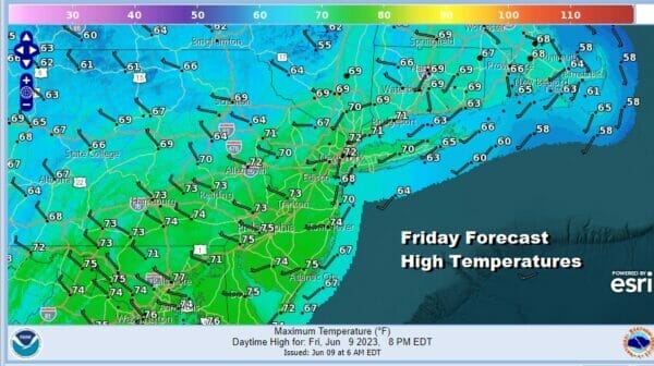
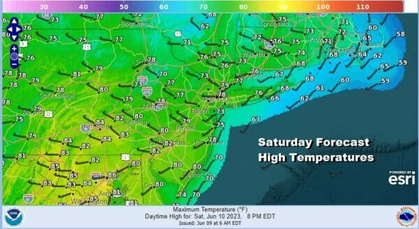
Showers will go away tonight with leftover clouds and some partial clearing of skies. Most lows will be in the upper 40s to mid 50s. Saturday look for a mix of sun and clouds as the upper trough takes its time moving east and there is the chance for an isolated shower or thunderstorm. Saturday highs will be
Assuming that the smoke issues improve Sunday will turn out to be the best day of the weekend. It will also turn out to be a very warm to hot day thanks to southwest winds ahead of the next cold front. No rain is forecast Sunday. We will have sunshine and probably some haze with highs in the 80s to near 90 degrees in some hot spots. Temperatures will be cooler along the shore.
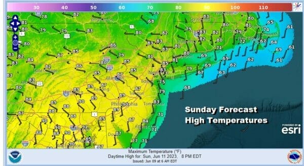
There might be an isolated shower or thunderstorm inland Sunday evening but there is a higher chance for showers and thunderstorms later Sunday night and during the day Monday until the cold front passes. This will be the first significant rain in a few weeks and we could see up to an inch of rain in some heavier thunderstorms. Temperatures Monday will be in the 70s.
BE SURE TO DOWNLOAD THE FREE METEOROLOGIST JOE CIOFFI WEATHER APP &
ANGRY BEN’S FREE WEATHER APP “THE ANGRY WEATHERMAN!
MANY THANKS TO TROPICAL TIDBITS FOR THE USE OF MAPS
Please note that with regards to any severe weather, tropical storms, or hurricanes, should a storm be threatening, please consult your local National Weather Service office or your local government officials about what action you should be taking to protect life and property.
(Amazon is an affilate of Meteorologist Joe Cioffi & earns commissions on sales.)


