Slowly Turning More Humid Next 2 Days Heat Wednesday Thursday
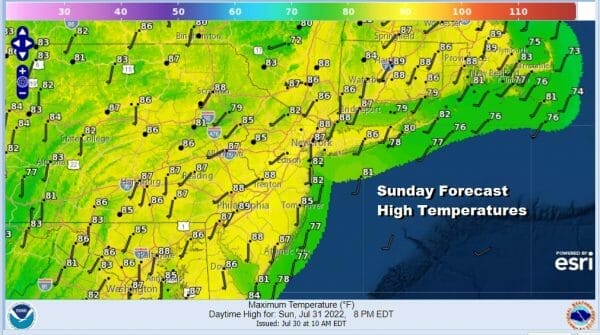
The second day of the weekend starts as nice as yesterday but there are a few changes that will be getting underway. Firstly from south to north we will see dew points begin to rise so the humidity will be coming up a bit. It won’t be reaching truly uncomfortable levels but you may notice a difference this afternoon. The other is a disturbance moving east out of the upper Ohio Valley and that could bring some clouds to mix with the sunshine later today. There will be enough sun today to take temperatures up to the middle to upper 80s though it will be cooler at the shore.
SATELLITE

WEATHER RADAR

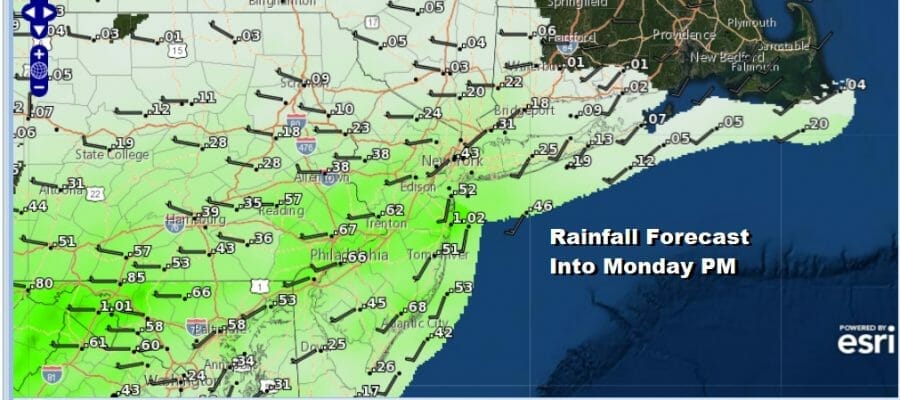
The regional radar is showing some showers moving northeastward on the lower left and we could see some showers or a period of rain overnight into Monday morning. It sets up where the steadier rain such as it is, will be more to the south across Southern Pennsylvania and Southern New Jersey and less to the north.

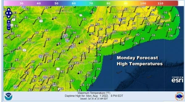
This rainfall and weather system doesn’t appear to be the type that can outperform. Once it moves through and out early Monday morning, clouds will give way to some sun by Monday afternoon. A south wind will mean humidity levels will be much higher and temperatures will top only in the low to middle 80s.
Tuesday begins what should be 4 days of heat. A weather front will be approaching so it will be very humid with some sunshine. Highs will reach into the 90s in most places. Late in the day we could see a thunderstorm or two as this front goes by but this does not appear to be a system that produces anything more than scattered activity.
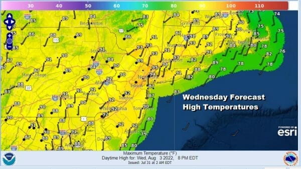
Thursday will likely be the hottest day this week with sunshine taking highs up to between 95 and 100 degrees with high humidity. In spite off the heat and the humidity nothing more than an isolated shower or thunderstorm will develop and the chances are rather low. Friday will still be hot but we do have another weather front and a better chance for showers and thunderstorms later in the day. Highs Friday will be in the 90s in most places. A short break will follow next weekend.
BE SURE TO DOWNLOAD THE FREE METEOROLOGIST JOE CIOFFI WEATHER APP &
ANGRY BEN’S FREE WEATHER APP “THE ANGRY WEATHERMAN!
MANY THANKS TO TROPICAL TIDBITS & F5 WEATHER FOR THE USE OF MAPS
Please note that with regards to any severe weather, tropical storms, or hurricanes, should a storm be threatening, please consult your local National Weather Service office or your local government officials about what action you should be taking to protect life and property.


