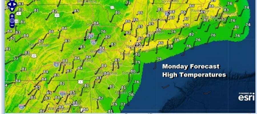
Slow Improvement Today But Humid Tuesday Into Friday Hot Humid
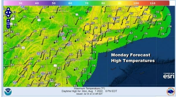
Overnight we saw an area of rain move through and while it wasn’t exactly a widespread soaking rain, most places were able to put down a quarter to as much as a half inch so that certainly was welcomed. Now as the rains pull away to the east we are left in a warm and humid air mass. Leftover clouds should give way to brightening of skies later today and perhaps some afternoon sun. The clouds and the south wind will hold temperatures down today and highs will just be into the 80s with 70s along the shore.
SATELLITE

WEATHER RADAR

Warm and humid conditions contunue tonight with lows in the mid 60s to lower 70s except middle 70s in warmer urban locations. Tuesday begins the first of what will likely be 4 hot days of weather. We do have a weather front approaching on Tuesday however there isn’t much support ahead of it for nothing more than an isolated shower or thunderstorm and the vast majority of you will see no rain.

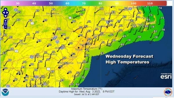
Wednesday will be a very warm to hot day but Tuesday’s weather front does bring some dew point relief for most of the day. We will see dew points drop to the upper 50s and lower 60s in most places which calculates to reasonable humidity. Highs will be very warm to hot with readings reaching the upper 80s to lower 90s. We should see a good deal of sunshine.
Thursday will be the hottest day of the week. We will start the day with temperatures in the 70s to around 80 in warmer urban areas and head for highs between 95 and 100 degrees .We will have plenty of sunshine and there is little chance for an afternoon shower or thunderstorm. Dew points will be back in the upper 60s and lower 70s making it miderably uncomfortable.

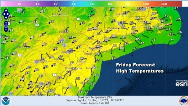
Friday we have a cold front approaching with more clouds ahead of it and that will cut down on the daytime heating so temperatures will be almost 10 degrees lower. Highs will still reach the upper 80s and lower 90s so for most of the region from Eastern Pennsylvania to Southern New England, this will be the 4th straight day of 90 degree plus highs.
Friday’s weather front will have some support in the upper atmosphere to trigger off some downpours and/or thunderstorms. While they could come at anytime, the late afternoon and evening will be the most favorable time for thunderstorms to develop.
This front may temporarily get hung up Friday night and Saturday which will cause lingering clouds and perhaps a few scattered showers early in the day. Highs will be just in the upper 70s and lower 80s and it will still be on the humid side. The front does eventually sink south and east and Sunday will be a hot and somewhat humid day with sunshine and highs in the upper 80s and lower 90s. Later next week we could see a rather robust cooler air mass come into the Eastern US at some point.
BE SURE TO DOWNLOAD THE FREE METEOROLOGIST JOE CIOFFI WEATHER APP &
ANGRY BEN’S FREE WEATHER APP “THE ANGRY WEATHERMAN!
MANY THANKS TO TROPICAL TIDBITS & F5 WEATHER FOR THE USE OF MAPS
Please note that with regards to any severe weather, tropical storms, or hurricanes, should a storm be threatening, please consult your local National Weather Service office or your local government officials about what action you should be taking to protect life and property.


