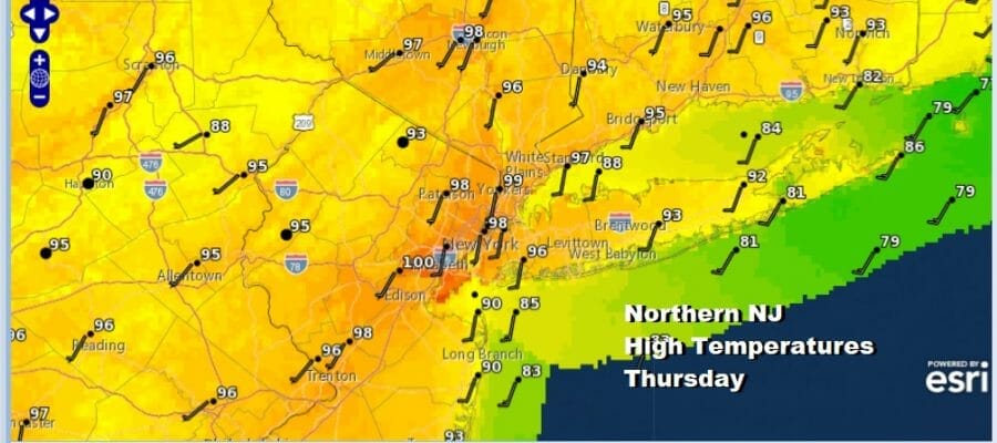
New Jersey Heat Begins Tuesday Thursday Highs 95 to 100 Degrees
Another stretch of hot humid weather is about to begin but before we get there, the rest of today features a lot of leftover clouds on the satellite. Improvement has taken longer but we are at least seeing skies brightening up and these clouds will disappear as we move through this evening and tonight for New Jersey. Overnight lows will be in the mid 60s to lower 70s except middle 70s near the warmer urban areas like Newark and in the Trenton to Philadelphia corridor.
SATELLITE

WEATHER RADAR

Showers and thunderstorms will be few and far between until the end of the week so we have heat and humidity of varying degrees to contend with in the coming days. Tuesday will be hot and humid as most highs in New Jersey will be in the low 90s though it will be only a little cooler at the shore with local sea breezes. An isolated shower or thunderstorm is possible. Wednesday will be hot but the humidity will be a little lower especially in North Jersey. Highs will reach the lower 90s state wide.
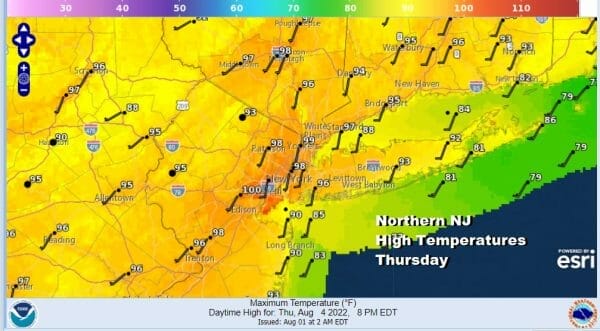
Thursday is setting up to be the hottest day of the week and similar to what we saw on those brutal hot days last week. Look for sunshine and probably no showers and thunderstorms during the day but some thunderstorms in Eastern Pennsylvania might make it into Western NJ before falling apart. Highs will reach 95 to near 100 degrees with the hottest temperatures in those counties that border NYC and Newark.

Southern New Jersey highs will be in the mid to upper 90s and a few spots might nick 100 degrees briefly. Humidity Thursday will be very high with dew points reaching 70 or so and that is oppressive. Some slight relief however should be available at the Jersey shore with a south wind which should hold temperatures down by 10 to 15 degrees (after the highs of the day are reached). Friday brings a cold front and an icnreasing chance for showers and thunderstorms. It will be very warm to hot but temperatures will be lower than Thursday, upper 80s to lower 90s should do it.
BE SURE TO DOWNLOAD THE FREE METEOROLOGIST JOE CIOFFI WEATHER APP &
ANGRY BEN’S FREE WEATHER APP “THE ANGRY WEATHERMAN!
MANY THANKS TO TROPICAL TIDBITS & F5 WEATHER FOR THE USE OF MAPS
Please note that with regards to any severe weather, tropical storms, or hurricanes, should a storm be threatening, please consult your local National Weather Service office or your local government officials about what action you should be taking to protect life and property.