Slow Improvement Over the Weekend
Warm Dry Weather Sunday Through Thursday

Slow Improvement Over the Weekend
Warm Dry Weather Sunday Through Thursday

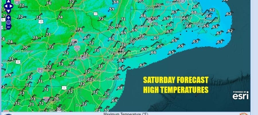
Yesterday’s record rainfalls are done but there are still some lingering areas of light rain around. However that won’t last long as the inverted trough and low pressure offshore begins its move southward. Dry air and higher pressures will begin building into the Northeast and Mid Atlantic today drying up the leftover rain and then gradually, we will begin the process of decreasing clouds today. It might take a while for improvement to really take hold but it will. Areas to the west of the coast might see some sunshine develop during this afternoon with late day clearing along the coast. Highs today should be able to rise into the 70s inland but where clouds are stubborn, upper 60s should do it.
SATELLITE WITH LIGHTNING STRIKES

WEATHER RADAR

Often times when the atmosphere has let go in a big way it needs to take an extended break and we seem to be in position for a lengthy stretch of rain free weather. The ridge that builds in the Eastern US should be the dominating force all week long as high pressure hangs around in the Eastern US for the next 4 or 5 days. This means rain free conditions as well as above normal temperatures.

Skies will become partly to mostly clear tonight with most lows in the 50s though there will be some 40s in normally cooler inland locations. Sunday will be a very nice day with sunshine. Highs Sunday will be in the 70s everywhere. Just about everywhere in the eastern half of the US will enjoy a nice day.

Monday through Thursday the forecast outlook is relatively easy. We should see sunshine each day with a minimal amount of cloud cover. Given the time of year, the longer nights and a stable atmosphere might allow for low clouds and some fog to develop during nighttime and early morning hours only to burn off quickly. No rain is forecast through Thursday with highs each day reaching the mid 70s to around 80 degrees in some hot spots. The next cold front will likely approach later Friday and with that we will see a chance for some showers. Cooler air will arrive next weekend and no major rain storms or minor ones lie ahead of us. After yesterday’s rains, this is a good thing.
BE SURE TO DOWNLOAD THE FREE METEOROLOGIST JOE CIOFFI WEATHER APP &
ANGRY BEN’S FREE WEATHER APP “THE ANGRY WEATHERMAN!
MANY THANKS TO TROPICAL TIDBITS FOR THE USE OF MAPS
Please note that with regards to any severe weather, tropical storms, or hurricanes, should a storm be threatening, please consult your local National Weather Service office or your local government officials about what action you should be taking to protect life and property.
(Amazon is an affilate of Meteorologist Joe Cioffi & earns commissions on sales.)


