Slow Improvement Continues Sunshine Sunday & Monday
Next Storm Brings Rain Thunderstorms Late Week

Slow Improvement Continues Sunshine Sunday & Monday
Next Storm Brings Rain Thunderstorms Late Week
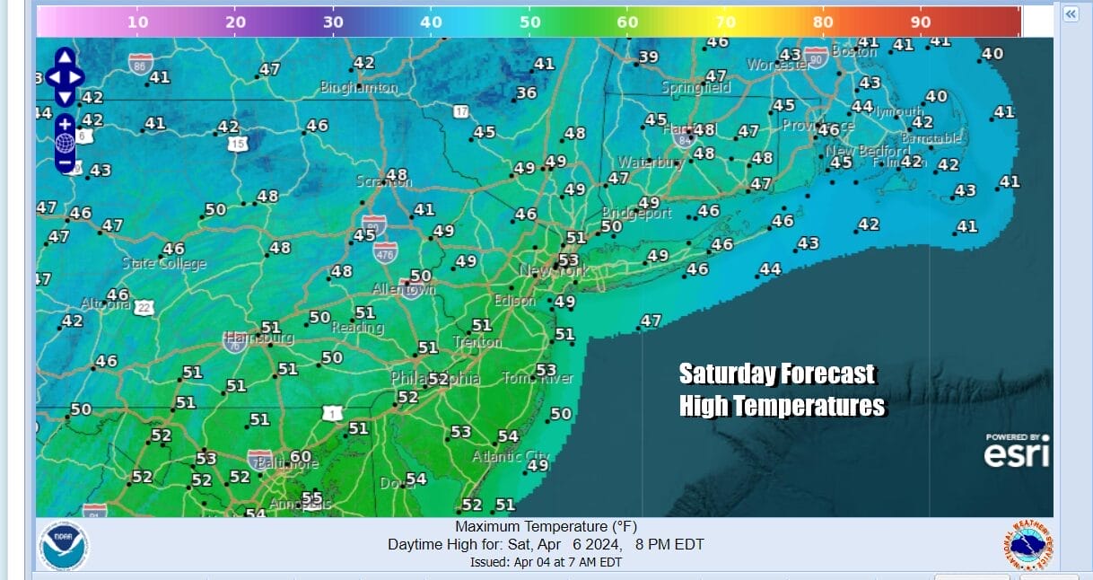
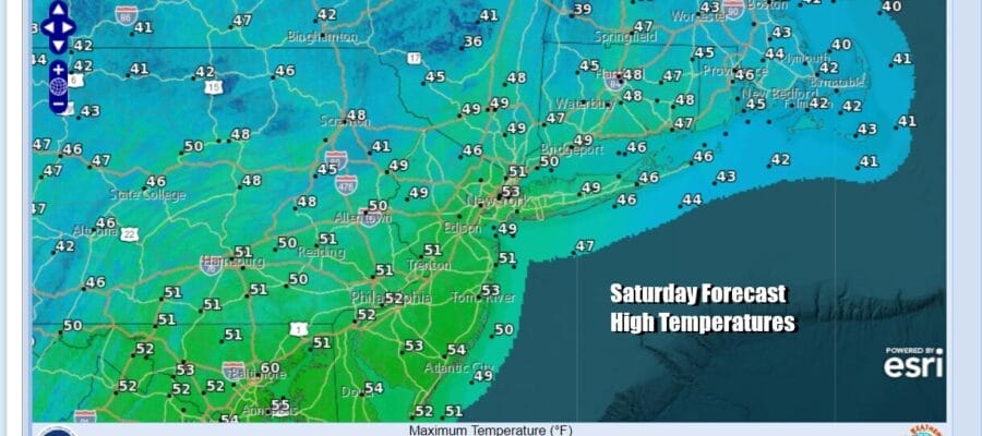
We have arrived at the weekend and we will continue to slowly improve weatherwise today. The upper low that has been moving across the Northeast is now exiting to the east in the Gulf of Maine. We will still have a bit of an unstable atmosphere today but in general we should see a bit more in the way of sunshine and a bit less in the way of coulds. It won’t be picture perfect but it will be better than it has been. Highs today will be back into the low and middle 50s. Radars are calmer today and while there still could be the odd scattered shower, for the most part this will be a rain free day.
SATELLITE WITH LIGHTNING STRIKES

WEATHER RADAR

Most lows tonight will be in the mid 30s to lower 40s as skies become partly to mostly clear. Sunday will finally ba day that will feature sunshine from start to finish and there should be nothing more than some passing clouds. More sunshine means higher temperatures and we should see highs in the mid to upper 50s. This is right where we should be for this time of year.

Monday is the big day. A total eclipse of the sun is visible across the US with the path of totality passing across Upstate NY and Northern New England. High clouds from a dying storm to the west will be moving east during Monday which is why you see high perecentage cloud cover numbers in Western NY. Ideal locations in the path of totality will be North Central and Northeastern NY as well as Northern New England.

A fair amount of sunshine will take highs into the 60s in many locations Monday afternoon except for south and east facing shorelines that might see local sea breezes develop. Longer range we should hold on to nice conditions Tuesday but we seem to be setting up for another wind and rain event for late next week Gulf of Mexico low pressure looks to move up the Appalachians leading a set up for rain and possibly thunderstorms along with gusty southerly winds ahead of a cold front. Some lead rain could develop Wednesday but the bulk seems to come Thursday into Friday.
BE SURE TO DOWNLOAD THE FREE METEOROLOGIST JOE CIOFFI WEATHER APP &
ANGRY BEN’S FREE WEATHER APP “THE ANGRY WEATHERMAN!
MANY THANKS TO TROPICAL TIDBITS FOR THE USE OF MAPS
Please note that with regards to any severe weather, tropical storms, or hurricanes, should a storm be threatening, please consult your local National Weather Service office or your local government officials about what action you should be taking to protect life and property.
(Amazon is an affilate of Meteorologist Joe Cioffi & earns commissions on sales.)


