Slow Descent into the Land of Gloom & Doom But It Is A Short Stay

Slow Descent into the Land of Gloom & Doom But It Is A Short Stay

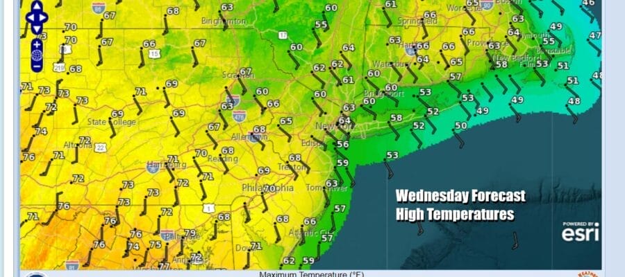
Much of today should be a decent day. We have a cold front to the west that is moving slowly eastward but we have some time before clouds and rain take over. Look for sunshine to give way to arriving clouds as we move through this Wednesday. Onshore winds are developing so this is going to create a wide range in temperatures. Highs will be in the upper 50s and lower 60s from NYC north and east into Southern New England and Long Island. South and west of Philadelphia, highs will reach the mid to upper 60s.
SATELLITE WITH LIGHTNING STRIKES

WEATHER RADAR

Rain is still quite a bit away from Eastern Pennsylvania to Southern New England during this morning but we will see it advance this afternoon. The cold front will slow down and a warm front to the south will set up. Low pressure will develop on that warm front and that will strengthen the onshore flow. Once rain gets in here temperatures will fall.

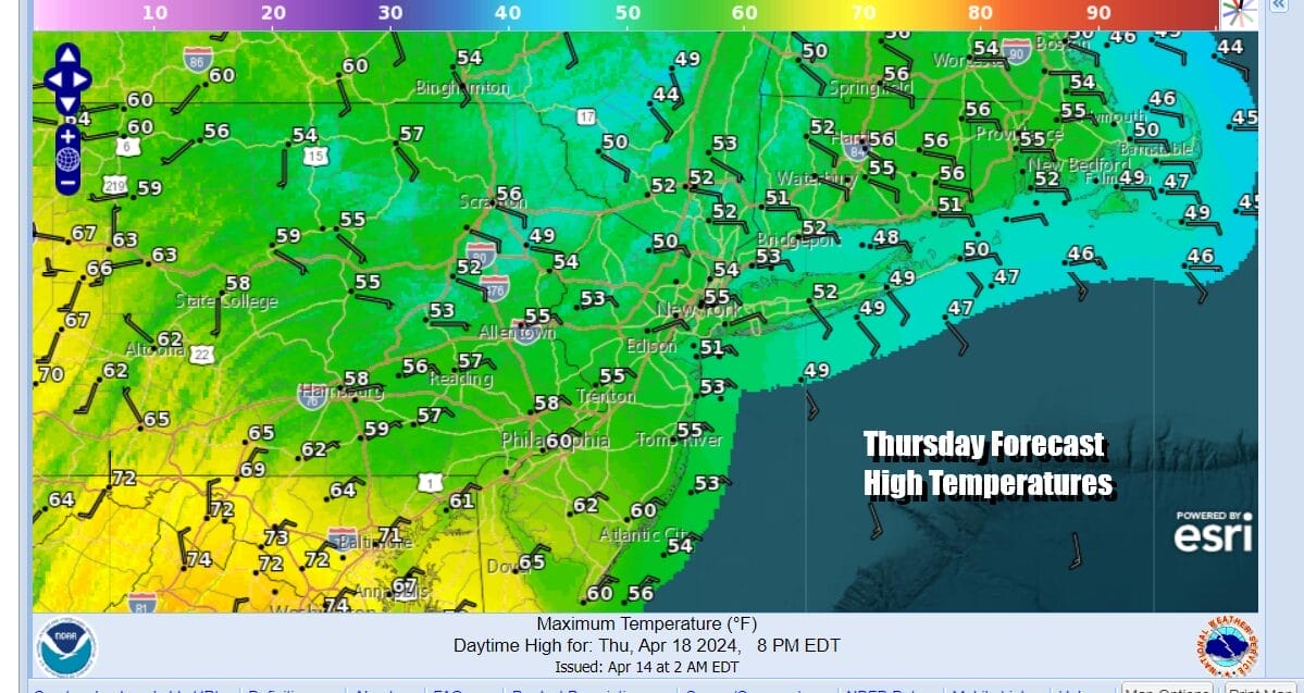
The good news is that weather systems are moving along so this set up for “gloom & doom” conditions will only last for a day or so. Rain will fall tonight and continue on and off through the day Thursday. The wind will be off the ocean and that will keep temperatures in the upper 40s and lower 50s for highs. It is going to be a raw and miserable type of day. Rainfall amounts will be in a range of a half to maybe three quarters of an inch. There dones’t appear to be much room for upside.
This wave and front will move out Thursday night but it will be followed by another front for later Friday and Friday night. while this front is likely to produce a few showers they should be relatively contained. Friday itself looks like a day of clouds and some sunshine with some showers possible late in the day into Friday night. Rain won’t amount to much.
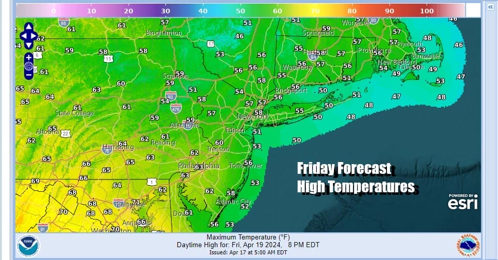
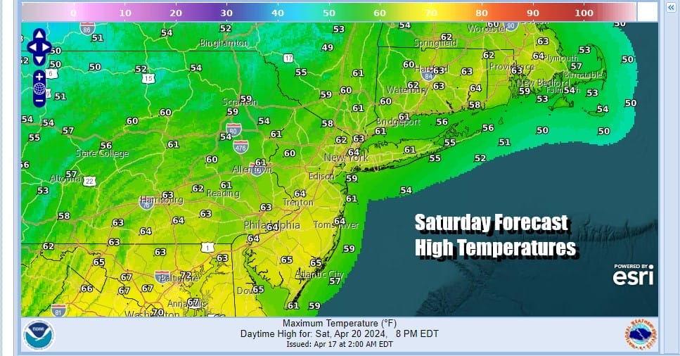
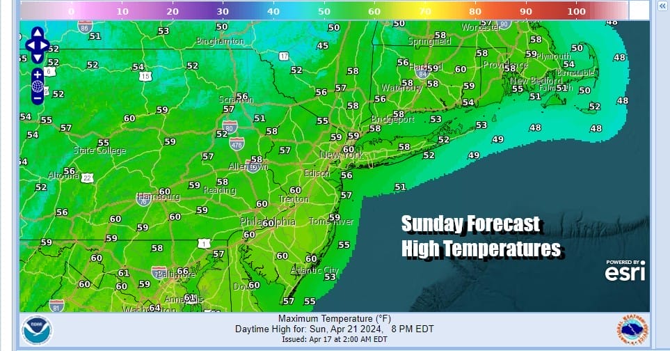
We are going into a cooler than normal temperature pattern that will last into early next week. Friday highs will be in the upper 50s to lower 60s. Once the front passes we are looking at a nice but cool weekend. The front passes far to the south so that any wave that comes out of the Gulf of Mexico will pass to our south. This leaves us with sunshine and a few clouds Saturday and Sunday. Highs both days will be in the 50s to around 60 degrees both days. It may be a bit breezy at times especially on Saturday but the wind should not get out of control.
We seem to be out of the pattern of major rainstorm after major rainstorm and next week looks to be a bit more on the quiet side. It will not be completely rain free as we will probably see some sort of front or low pressure area approach sometime in the middle of next week. However at least we have some rain free weather to look forward to once we get done with the next couple of days.
BE SURE TO DOWNLOAD THE FREE METEOROLOGIST JOE CIOFFI WEATHER APP &
ANGRY BEN’S FREE WEATHER APP “THE ANGRY WEATHERMAN!
MANY THANKS TO TROPICAL TIDBITS FOR THE USE OF MAPS
Please note that with regards to any severe weather, tropical storms, or hurricanes, should a storm be threatening, please consult your local National Weather Service office or your local government officials about what action you should be taking to protect life and property.
(Amazon is an affilate of Meteorologist Joe Cioffi & earns commissions on sales.)


