Showery Rains Tonight into Thursday Morning More Showers Over the Weekend

Showery Rains Tonight into Thursday Morning More Showers Over the Weekend

We are actually going to see nice weather for much of the dayside. The satellite is showing just some patchy clouds so we should have a fair amount of sunshine into this afternoon. Clouds from the next storm system and cold front will probably not arrive until this evening and the rains will likely not arrive until around midnight or so. So it is a day of partly sunny skies from Eastern Pennsylvania to Southern New England. Highs will be in the upper 70s and lower 80s. Radars are nice and quiet and will remain so for the rest of the day.
SATELLITE

WEATHER RADAR

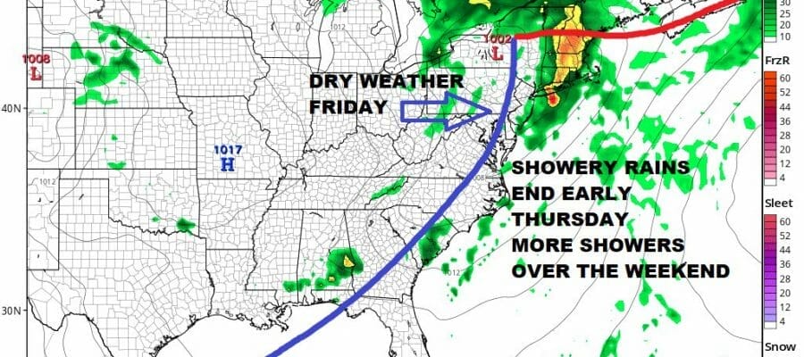
Tonight we see the storm system track across Ohio and Western Pennsylvania and into Upstate NY late tonight into Thursday morning. There is an arm of rain with this system that will move through and it will last no more than 6 hours which limits rainfall to 3/4 inch to 1.25 inches. Temperatures overnight will hold mostly in the 60s. There is some severe weather risk for an isolated severe thunderstorm mainly from Southern New Jersey and Southern Pennsylvania southward.

Once the rains end weather conditions will slowly improve with decreasing clouds and some afternoon sunshine developing. Highs will reach the upper 70s and lower 80s. We will remain dry through Friday which will start with sunshine and perhaps finish off with some arriving clouds. Overall though it will be a nice finish to the week with highs again in the seasonal upper 70s and lower 80s.

As far as the weekend goes we another low coming east across the Tennessee Valley and then hooking northeast up along the coast late Friday night into Saturday afternoon. This system does not look as robust as it did a few days ago but we will see showery rains into early Saturday afternoon before they taper off. Highs Saturday will be in the mid 60s coast and low 70s inland. Sunday brings an upper trough and cold front so we see the chance for showers and thunderstorms in the afternoon. Highs Sunday will be in the mid to upper 70s. Next week looks mostly dry as a northwest flow from Canada takes control and we may not see any showers and thunderstorms until late in the week.
BE SURE TO DOWNLOAD THE FREE METEOROLOGIST JOE CIOFFI WEATHER APP &
ANGRY BEN’S FREE WEATHER APP “THE ANGRY WEATHERMAN!
MANY THANKS TO TROPICAL TIDBITS & F5 WEATHER FOR THE USE OF MAPS
Please note that with regards to any severe weather, tropical storms, or hurricanes, should a storm be threatening, please consult your local National Weather Service office or your local government officials about what action you should be taking to protect life and property.


