
Showery Rains Thunderstorms Next Several Days As Upper Low Remains Stalled

The next several days are going to feature a stalled upper low and surface low to the west in the Appalachians and a north south frontal boundary. Not much is going to change until probably Thursday as the upper low spins around and showery rains & thunderstorms lift northward around it. Showery rains and some heavier downpours will not be continuous but will come in waves. There will be a few thunderstorms in the mix and there is always the chance for an isolated severe thunderstorm in the mix.
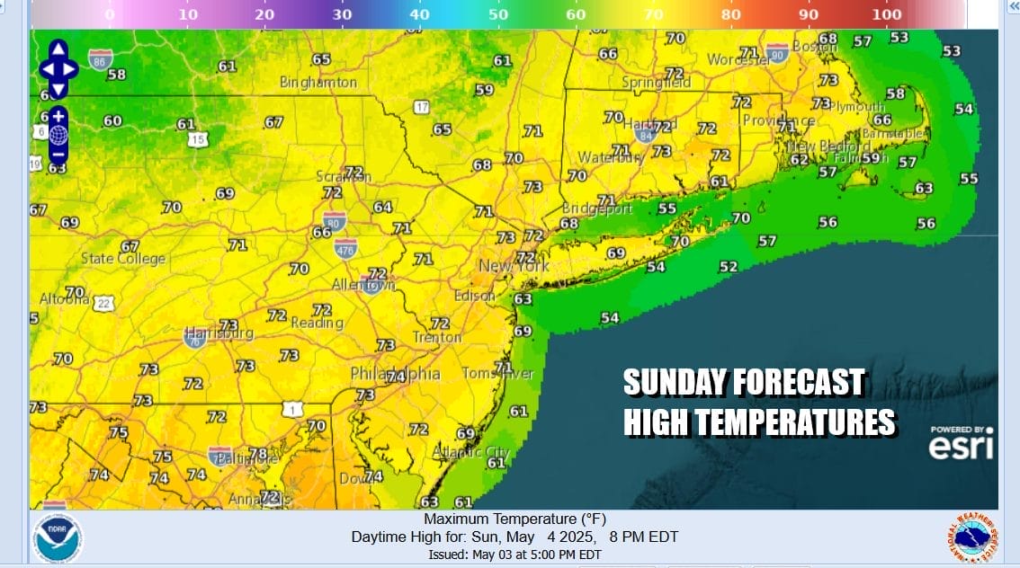
You can see the rotation to the west on the satellite and radar loops as the driving engine of this wet pattern. It will remain warm and humid so when it is not raining it will be very sticky. The sun might even try to come out but that will only make the atmosphere more unstable causing more showers and downpours to develop. Temperatures today will be in the 70s except for the shore where it will be mostly in the 60s.
SATELLITE WITH LIGHTNING STRIKES

WEATHER RADAR

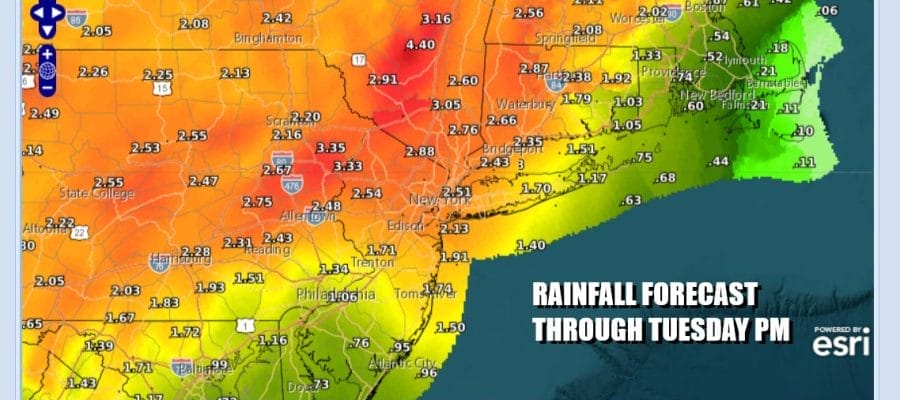
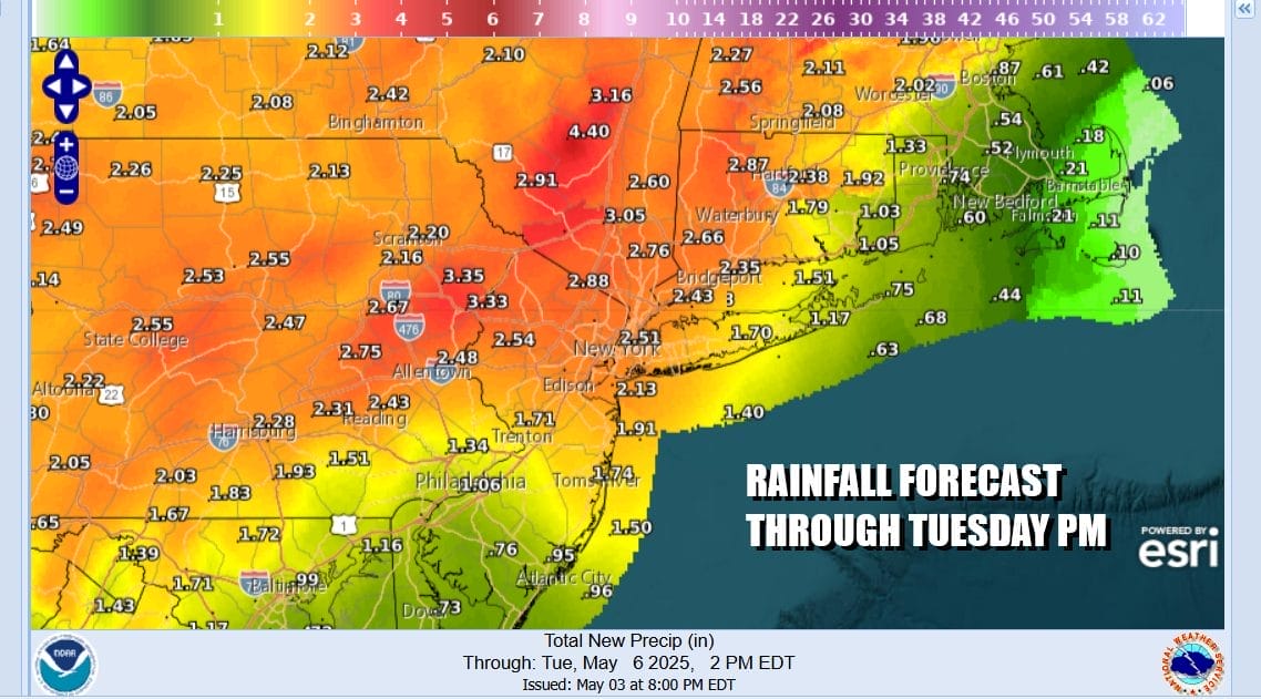
Rainfall totals will vary and will depend on where the heaviest downpours and thunderstorms settle. They are likely to sit overhead for awhile or at best move slowly and then get replaced by other showers. The heaviest rains of 2 inches or more are likely across Northern New Jersey, Long Island and Southern New England as well as the Hudson Valley and some localized flash flooding is possible.
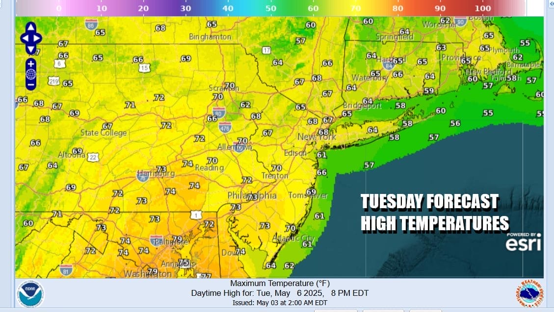
Temperatures Sunday night will likely not drop much below the 60s in most places. Monday we will see highs in the 70s and the same goes for Tuesday. There may be some dry periods on both days between bands of showers rotating around the upper low which will start to move northeastward later Tuesday from the Ohio Valley and into New England late Wednesday.

By Wednesday with the upper low over New England, bands of showers will diminish some but they won’t be completely gone so we will include some showers in the forecast along with some periods of self destructive sunshine. High Temperatures Wednesday will be in the 70s. Once the upper low pulls out, we will finally see drying conditions for Thursday and Friday with sunshine for both days. Highs both days will be in the low to middle 70s.
BE SURE TO DOWNLOAD THE FREE METEOROLOGIST JOE CIOFFI WEATHER APP &
ANGRY BEN’S FREE WEATHER APP “THE ANGRY WEATHERMAN!
MANY THANKS TO TROPICAL TIDBITS FOR THE USE OF MAPS
Please note that with regards to any severe weather, tropical storms, or hurricanes, should a storm be threatening, please consult your local National Weather Service office or your local government officials about what action you should be taking to protect life and property.


