
Showery Rains Around Tonight Severe Weather Risk Wednesday Fred Tracks West

Weather in 5/Joe & Joe Weather Show Latest Podcast
Showery Rains Around Tonight Severe Weather Risk Wednesday Fred Tracks West
The transition to warm tropical air continues. A warm front lies just across the area this afternoon and to the south of that is the warm tropical air that has the remnant low of Tropical Storm Fred. Heavy rains have been widespread in Georgia and the Western Carolinas with some areas getting 4 to 6 inches of rain so far.

Fred lies on the lower left of the satellite view this evening with Tropical Storm Henri visible on the lower right. Both systems are encased inside a broad area of tropical air which is the atmosphere basically getting primed up for something. In the meantime look for cloudy skies warm and humid conditions tonight with scattered showery rains around and lows in the upper 60s and lower 70s
SATELLITE

Fred rains are not yet in view of the local and regional radars. You see patches of showers around mostly on the regional radar this evening but they will appear on local radars tonight. Not everyone will see showers overnight but those that do could also see a heavy downpour or two.
WEATHER RADAR


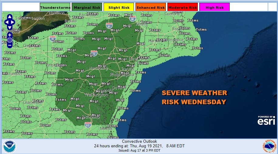
Wednesday much of the area will be east of the track of the remnant low of Fred. This is going to put us in the warm sector with tropical conditions and temperatures reaching into the 80s. This sets the stage for some severe weather risk and the Storm Prediction Center is indicating a marginal risk for severe weather Wednesday from Virginia to the Hudson Valley. Long Island and Southern New England lie outside the risk zone. The marginal risk zone carries a 2 percent tornado risk.
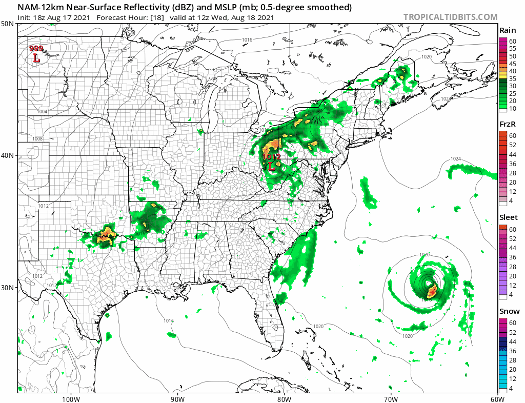
Looking at the NAM model this afternoon the bulk of the rains around Fred pass well to the west and we again think that the bulk of any heavy flooding rains will be from I-81 west with some rain extending to the I-95 corridor from NYC southward. Much of Wednesday will see some scattered passing showers and then we will watch the radars for any stronger thunderstorms that might develop late in the afternoon and evening. Temperatures Wednesday reach into the 80s with dew points at 70 or better making for a very humid day.
No break in the humidity on Thursday as a weather front approaches with maybe a shower or thunderstorm at the end of the day. Otherwise it will be very humid with some sun and highs in the 80s. The front is going to get hung up near the coast Friday and basically fall apart. On the lower right is Henri and we are seeing it get a little closer to the North Carolina coast by early Saturday morning.

It should pass far enough offshore not to create any issues other than roughing up the surf a bit but the upper air is a bit interesting on the afternoon model runs and we are going to pay a little closer attention tonight and Wednesday to see where this is all going.
BE SURE TO DOWNLOAD THE FREE METEOROLOGIST JOE CIOFFI WEATHER APP &
ANGRY BEN’S FREE WEATHER APP “THE ANGRY WEATHERMAN!

MANY THANKS TO TROPICAL TIDBITS & F5 WEATHER FOR THE USE OF MAPS
Please note that with regards to any severe weather, tropical storms, or hurricanes, should a storm be threatening, please consult your local National Weather Service office or your local government officials about what action you should be taking to protect life and property.


