
Showers Thunderstorms Possible Into Saturday Night
Showers Thunderstorms Possible Into Saturday Night
New Jersey took the brunt of the showers and thunderstorms that developed this afternoon and we see busy radars all around us though it seems that how the thunderstorms lined up has left some areas with very little and other areas saw quite a bit.
Showers Thunderstorms Possible Into Saturday Night
Storm Totals as of 7PM
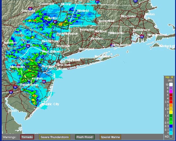
A large area of Western New Jersey picked up anywhere from 2 to 3 inches of rain so far from the late afternoon and evening thunderstorms that developed there. What stands out is the lack of rainfall in eastern areas like Long Island and Connecticut. You can thank the warm front that set up to the west of these areas. This put eastern areas in a cooler marine layer which is a notorious thunderstorm killer.
Going forward overnight there are still some downpours on the radar and I think some of those will move into areas that missed out on the first round. They may come in during the overnight.
REGIONAL RADAR

Local Radars


Showers Thunderstorms Possible Into Saturday Night
NAM Model 3pm Saturday 

The next and final cold front arrives Saturday and it appears now that some showers are going to be possible with this front when it moves on through. The NAM shows this well as do the other models. The HRRR has not been good at all (yet again) and I won’t even look at it. The NAM model has been pretty good with its presentation lately so we will go with this idea. Saturday will see lots of clouds otherwise with temperatures in the 70s to near 80. Drying should take hold on Sunday with some sunshine and lower humidity with highs in the upper 70s to lower 80s.
FiOS1 News Weather Forecast For Long Island
FiOS1 News Weather Forecast For New Jersey
FiOS1 News Weather Forecast For Hudson Valley
NATIONAL WEATHER SERVICE SNOW FORECASTS
LATEST JOESTRADAMUS ON THE LONG RANGE
Weather App

Don’t be without Meteorologist Joe Cioffi’s weather app. It is really a meteorologist app because you get my forecasts and my analysis and not some automated computer generated forecast based on the GFS model. This is why your app forecast changes every 6 hours. It is model driven with no human input at all. It gives you an icon, a temperature and no insight whatsoever.
It is a complete weather app to suit your forecast needs. All the weather information you need is right on your phone. Android or I-phone, use it to keep track of all the latest weather information and forecasts. This weather app is also free of advertising so you don’t have to worry about security issues with your device. An accurate forecast and no worries that your device is being compromised.
Use it in conjunction with my website and my facebook and twitter and you have complete weather coverage of all the latest weather and the long range outlook. The website has been redone and upgraded. Its easy to use and everything is archived so you can see how well Joe does or doesn’t do when it comes to forecasts and outlooks.
Just click on the google play button or the apple store button on the sidebar for my app which is on My Weather Concierge. Download the app for free. Subscribe to my forecasts on an ad free environment for just 99 cents a month.
Get my forecasts in the palm of your hand for less than the cost of a cup of Joe!

MENTION JOE CIOFFI AND GET A 5% DISCOUNT


