
Severe Weather Threat Saturday New Jersey Hudson Valley
Severe Weather Threat Saturday New Jersey Hudson Valley
The Storm Prediction Center of the National Weather Service has once again indicated a severe weather threat Saturday New Jersey Hudson Valley & Eastern Pennsylvania. The risk is marginal but bear in mind that today’s risk was marginal and it resulted in flash flooding and 3 to 4 inch rainfalls for parts of North Central New Jersey. Tomorrow’s storms will frontal in nature and with less tropical air around I think wind might wind up being the bigger issue. We will of course have to monitor the situation during the day Saturday and see how things evolve.
HERE IS THE LATEST VIDEO ANALYSIS OF SATURDAY’S SEVERE WEATHER THREAT
[brid video=”53944″ player=”6390″ title=”SEVERE WEATHER THREAT”]
Severe Weather Threat Saturday New Jersey Hudson Valley Eastern Pennsylvania Per Storm Prediction Center
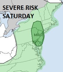
STORM PREDICTION CENTER SEVERE WEATHER RISK AREA FORECAST
PLEASE NOTE THE TIME STAMP AS THIS WILL BE UPDATED THIS MORNING BY S.P.C.

Regional Radar

Local Radars


Outlook for Saturday Through Monday
There will be a lot of clouds today which will hold temperatures down in most places. Highs will be in the 70s to around 80 on average. While there may be some showers from time to time, the main area of thunderstorms could come in the form of a line of storms late in the day and Saturday evening. Once that moves through. weather conditions will begin to improve and Sunday we should see a mix of sun and clouds with low humidity and highs in the upper 70s to lower 80s. Next week begins nice and dry with sunshine Monday and Tuesday with highs in the lower 80s on average. Then later next week we will see a return of some heat and humidity. More on that later today in a JOESTRADAMUS long range post.
FiOS1 News Weather Forecast For Long Island
FiOS1 News Weather Forecast For New Jersey
FiOS1 News Weather Forecast For Hudson Valley
NATIONAL WEATHER SERVICE SNOW FORECASTS
LATEST JOESTRADAMUS ON THE LONG RANGE
Weather App

Don’t be without Meteorologist Joe Cioffi’s weather app. It is really a meteorologist app because you get my forecasts and my analysis and not some automated computer generated forecast based on the GFS model. This is why your app forecast changes every 6 hours. It is model driven with no human input at all. It gives you an icon, a temperature and no insight whatsoever.
It is a complete weather app to suit your forecast needs. All the weather information you need is right on your phone. Android or I-phone, use it to keep track of all the latest weather information and forecasts. This weather app is also free of advertising so you don’t have to worry about security issues with your device. An accurate forecast and no worries that your device is being compromised.
Use it in conjunction with my website and my facebook and twitter and you have complete weather coverage of all the latest weather and the long range outlook. The website has been redone and upgraded. Its easy to use and everything is archived so you can see how well Joe does or doesn’t do when it comes to forecasts and outlooks.
Just click on the google play button or the apple store button on the sidebar for my app which is on My Weather Concierge. Download the app for free. Subscribe to my forecasts on an ad free environment for just 99 cents a month.
Get my forecasts in the palm of your hand for less than the cost of a cup of Joe!

MENTION JOE CIOFFI AND GET A 5% DISCOUNT