WARM HUMID CONDITIONS ON WEDNESDAY THUNDERSTORMS POSSIBLE
BEAUTIFUL WEATHER ARRIVES THURSDAY AND LASTS THROUGH THE WEEKEND
LOW HUMIDITY THURSDAY THROUGH SATURDAY
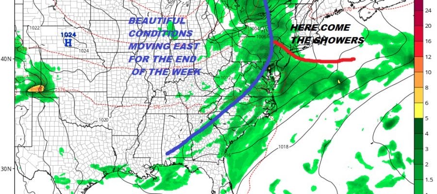
The long awaited arrival of a beautiful dry air mass is almost here but first we have some higher humidity and some showers to deal with a a warm front is coming up from the south. Ahead of that front we are seeing some downpours breaking out and to the west in Pennsylvania where the warm sector has already arrived, some severe thunderstorms have developed. The satellite loop shows clouds starting to push eastward as the warm front advances. Look for weather conditions to deteriorate overnight with some showers and possible thunderstorms rolling through especially during the early morning hours.
EASTERN SATELLITE

REGIONAL RADAR

Radars are starting to load up a bit with downpours and thunderstorms and they are all moving northeastward. Much of the shower activity should hold off until the evening commute is done though some showers could roll into South Jersey and Southeastern Pennsylvania this evening.
LOCAL RADAR NEW YORK CITY

LOCAL RADAR PHILADELPHIA


Wednesday we wait for a cold front to move through so it will be warm and humid with temperatures in the 80s and the chance for a shower or thunderstorm. Humidity levels will start to drop from west to east during the afternoon and evening and this sets us up for Thursday and Friday which will feature lots of sunshine low humidity and temperatures in the 70s.

The low humidity continues on Saturday with sunshine and highs in the upper 70s and lower 80s. Sunday the humidity creeps up a bit but it will still be relatively reasonable with sunshine and highs in the 80s. Next week looks like we will be getting one more burst of very warm to hot and humid weather at least to start the week. Sunshine and the risk for a daytime shower or thunderstorm is the outlook for Monday and Tuesday with highs in the 80s to near 90.
MANY THANKS TO TROPICAL TIDBITS FOR THE USE OF MAPS
Please note that with regards to any tropical storms or hurricanes, should a storm be threatening, please consult your local National Weather Service office or your local government officials about what action you should be taking to protect life and property.
LATEST JOESTRADAMUS ON THE LONG RANGE


