
Showers Thunderstorms Exit Unsettled Weather Continues All Week
We did think there was the chance for a scattered shower or two during the afternoon and evening and indeed we did get that in some spots. We also got a couple of thunderstorms that developed in Southern New Jersey and are moving to the east this evening. You can see what looks like a bright white stick of clouds over Southern New Jersey on the satellite picture.
SATELLITE

REGIONAL RADAR

We are also seeing showers and thunderstorms scattered around on the regional and local radar. All of this due to an upper trough moving very slowly through the Northeast tonight and part of that system will hang around into Wednesday which means we will be dealing with clouds tonight and clouds again on Tuesday.
LOCAL RADAR NEW YORK CITY

LOCAL RADAR PHILADELPHIA


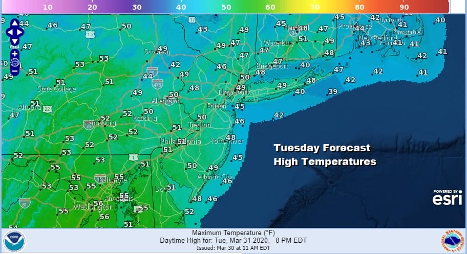
For some areas today in Southern Pennsylvania and Southern New Jersey it will be a cooler day. Highs this afternoon reached into the 60s so this area will be at least 5 to 7 degrees cooler on Tuesday. Areas to the north from Northern New Jersey to Southern New England were in the upper 40s and lower 50s today and that is what the highs are forecast for Tuesday. Clouds will be around with limited sun thanks to the lingering upper trough and a developing northeast wind.
Meanwhile a storm system that tonight is in the Southern Plains will move straight east to the Carolinas and then become a major ocean storm. The issue with this storm is that thanks to blocking it may wind up sitting out offshore. It will be far enough to spare us major issues but it may be close enough to throw clouds back westward from time to time and the occasional shower.

Wednesday will likely be a mostly cloudy day with highs in the 40s to some lower 50s inland. Thursday and Friday with the storm offshore we should see some sun but clouds will likely develop and as the GFS shows there is the chance we could see an arm of showers sweeping around from the northeast and dropping southward at some point late Thursday into Friday. The best chances for any showers would be in Southern New England south to Coastal New Jersey and Long Island with just clouds inland. Highs Thursday and Friday should be back into the 50s.
BE SURE TO DOWNLOAD THE FREE METEOROLOGIST JOE CIOFFI WEATHER APP &
ANGRY BEN’S FREE WEATHER APP “THE ANGRY WEATHERMAN!
MANY THANKS TO TROPICAL TIDBITS FOR THE USE OF MAPS
Please note that with regards to any severe weather, tropical storms, or hurricanes, should a storm be threatening, please consult your local National Weather Service office or your local government officials about what action you should be taking to protect life and property.


