Showers Moving East T-Storm Tonight Great Weather Follows
Showers Moving East T-Storm Tonight Great Weather Follows
The warm front is moving through now and the radar shows showers are exiting to the east. We will spend the rest of the afternoon in clouds as the satellite has us pretty much socked in though some brightening of skies could occur and even a few breaks of sun could show up.
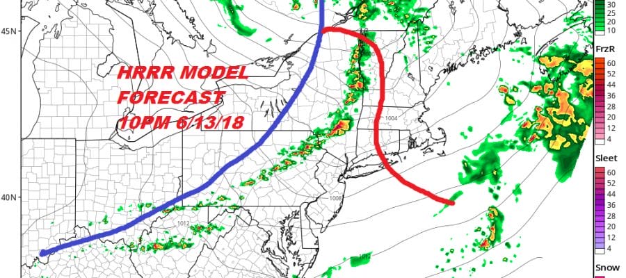
The clouds, the wind direction and the showers have kept the temperatures lower so we don’t seem to be getting the daytime heating required for strong thunderstorms. The better chance for storms this evening will be inland. The HRRR shows stronger storms in the Hudson Valley, Northeastern Pennsylvania and approaching NW New Jersey before the storms weaken rapidly afterwards.
HRRR MODEL 10PM 6/13/2018

The Storm Prediction Center still has inland areas at at marginal to slight risk for severe weather and there isn’t anything going on this afternoon that would indicate that the risk level will be raised. No severe thunderstorm watches are up at the moment.
EASTERN SATELLITE

REGIONAL RADAR

LOCAL RADAR NEW YORK CITY

LOCAL RADAR PHILADELPHIA


Once this all gets out of the way tonight we can start 4 days of great weather and then the 5th day Monday which will be the one hot and humid day of this stretch. Temperatures will be in the low to mid 80s Thursday. Friday will be a little cooler as a re-enforcement of dry cool air comes in on Friday so highs will be upper 70s to lower 80s. Saturday and Sunday will be sunny and very warm with highs in the 80s both days..some spots Sunday could reach 90. Humidity will still remain reasonable over the weekend before becoming humid on Monday when the heat gets turned on.
MONDAY 6/18/2018 2PM TEMPERATURES
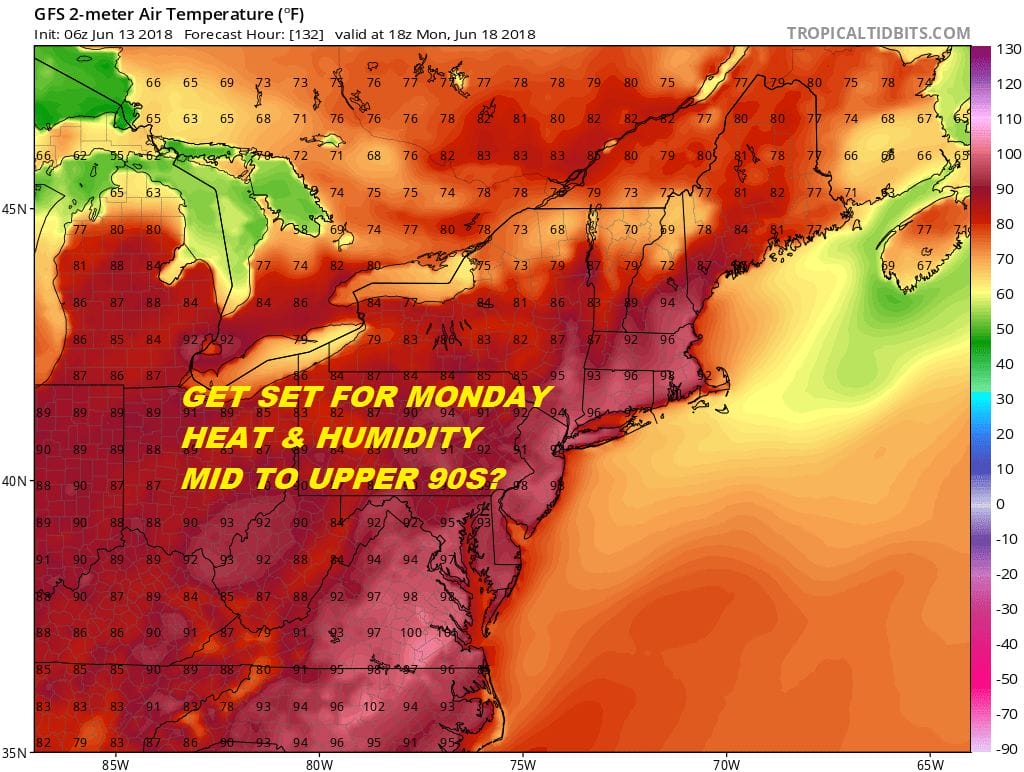
Highs Monday will be in the 90s and some places could reach middle or even upper 90s as long as we have enough sun. The risk for thunderstorms will return late Monday and Monday night as a cold front moves through. Low pressure which will have some of the remnants of Pacific Hurricane Bud will bring showers and cooler weather here next Tuesday.
 GET JOE A CIGAR IF YOU LIKE

FiOS1 News Weather Forecast For Long Island
FiOS1 News Weather Forecast For New Jersey
FiOS1 News Weather Forecast For Hudson Valley
NATIONAL WEATHER SERVICE SNOW FORECASTS
LATEST JOESTRADAMUS ON THE LONG RANGE


