
Showers Later Today Good Weekend

Showers Later Today Good Weekend
At least there are no red flag warnings for fire issues today as humidity levels are rising as will the temperatures this (Friday) afternoon. Highs will be in the 70s and if some breaks of sun occur, 80 isn’t out of the question. The weather system on the satellite loop in the midwest is making its way eastward. We will see some showers especially later this afternoon and this evening. Some thunderstorms could pop up but nothing severe is expected. Rainfall amounts remain on the low side and most areas will see a quarter of an inch with some isolated higher amounts. Check the satellite loop and the local radars which are updated in real time whenever you check this page or any of the forecast pages.

Showers Later Today Good Weekend REGIONAL RADAR

Showers Later Today Good Weekend LOCAL RADAR LOOPS


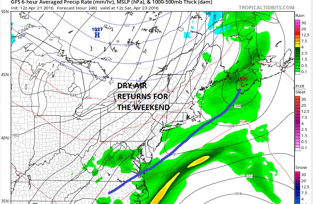
Showers will move out tonight and while there may be some leftover early morning clouds on Saturday in some areas, mainly coastal and east, we should quickly go partly to mostly sunny for Saturday with highs in the 60s to around 70. We will do it again on Sunday with sunshine and highs again in the 60s to around 70.
For Monday we have a weather system going by to our north which should mean some sun and clouds with temperatures reaching the 70s. Some areas in Southern New Jersey and Southeastern Pennsylvania could see temperatures in the upper 70s to around 80. Some showers and a thunderstorm could move through here Monday night as a front pushes south. Tuesday will be much cooler and we could see a period of rain as a weak wave goes by. No major storms or on the horizon. Have a great weekend.
FiOS1 News Weather Forecast For Long Island
FiOS1 News Weather Forecast For New Jersey
FiOS1 News Weather Forecast For Hudson Valley
NATIONAL WEATHER SERVICE SNOW FORECASTS
LATEST JOESTRADAMUS ON THE LONG RANGE
Weather App

Don’t be without Meteorologist Joe Cioffi’s weather app. It is really a meteorologist app because you get my forecasts and my analysis and not some automated computer generated forecast based on the GFS model. This is why your app forecast changes every 6 hours. It is model driven with no human input at all. It gives you an icon, a temperature and no insight whatsoever.
It is a complete weather app to suit your forecast needs. All the weather information you need is right on your phone. Android or I-phone, use it to keep track of all the latest weather information and forecasts. This weather app is also free of advertising so you don’t have to worry about security issues with your device. An accurate forecast and no worries that your device is being compromised.
Use it in conjunction with my website and my facebook and twitter and you have complete weather coverage of all the latest weather and the long range outlook. The website has been redone and upgraded. Its easy to use and everything is archived so you can see how well Joe does or doesn’t do when it comes to forecasts and outlooks.
Just click on the google play button or the apple store button on the sidebar for my app which is on My Weather Concierge. Download the app for free. Subscribe to my forecasts on an ad free environment for just 99 cents a month.
Get my forecasts in the palm of your hand for less than the cost of a cup of Joe!
![]()
![]()

MENTION JOE CIOFFI AND GET A 5% DISCOUNT