Showers Early Thursday

Showers Early Thursday Partly Sunny North
Friday Weekend Look Very Good
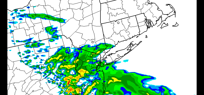
We are watching a disturbance in the Midwest that will be dropping southeastward. The vortex in Eastern Canada remains the driver here as it is forcing the disturbance to drop to our south. The issue for late tonight and Thursday morning will be the cloud line and the shower line. Northern areas from Northeast Pennsylvania to the Hudson Valley and Connecticut and Long Island will be on the edge of the clouds and showers will come close to New York City, Northern New Jersey and Western Long Island.
Showers Early Thursday HRRR MODEL

However we think the vortex wins out here and dry air will start pushing everything to the south. Central and Southern New Jersey and Southeastern Pennsylvania will probably sit in clouds for most of the day and take the brunt of the showers Thursday morning. Meanwhile areas to the north will gradually go partly sunny by late morning or early afternoon. Temperatures are going to be higher as you go north, mid to upper 70s..and lower as you go south..low to mid 70s depending on how much cloud cover there is.
Showers Early Thursday
Satellite Loop

The first batch of showers to the south are not an issue. The second batch is beginning to appear in Western Pennsylvania and Western New York. That is the area we will be watching as it moves east and southeast tonight into Thursday morning.
Showers Early Thursday
Radar Loops


Fathers Day Weather Outlook
Much of this should be far enough south so Friday will be dry with partly to mostly sunny skies. There could be some patchy clouds as you go south. Some models are showing some showers coming through late Thursday night into Friday morning in southern areas but we are discounting this at the moment. Saturday and Sunday look great with lots of sunshine. Temperatures Friday and Saturday will be in the 70s. Sunday’s highs will be in the 80s. Monday looks hot with many areas well into the 80s to near 90 with plenty of sun. The next important cold front with showers and thunderstorms will arrive later Tuesday.
For those of you looking for something to do, try the Mattituck Strawberry Festival on Long Island’s North Fork. Here is the latest forecast for Long Island and links to the strawberry festival.
JOESTRADAMUS HURRICANE SEASON GUEST FORECAST
FiOS1 News Weather Forecast For Long Island
FiOS1 News Weather Forecast For New Jersey
FiOS1 News Weather Forecast For Hudson Valley
NATIONAL WEATHER SERVICE SNOW FORECASTS
LATEST JOESTRADAMUS ON THE LONG RANGE
Weather App

Don’t be without Meteorologist Joe Cioffi’s weather app. It is really a meteorologist app because you get my forecasts and my analysis and not some automated computer generated forecast based on the GFS model. This is why your app forecast changes every 6 hours. It is model driven with no human input at all. It gives you an icon, a temperature and no insight whatsoever.
It is a complete weather app to suit your forecast needs. All the weather information you need is right on your phone. Android or I-phone, use it to keep track of all the latest weather information and forecasts. This weather app is also free of advertising so you don’t have to worry about security issues with your device. An accurate forecast and no worries that your device is being compromised.
Use it in conjunction with my website and my facebook and twitter and you have complete weather coverage of all the latest weather and the long range outlook. The website has been redone and upgraded. Its easy to use and everything is archived so you can see how well Joe does or doesn’t do when it comes to forecasts and outlooks.
Just click on the google play button or the apple store button on the sidebar for my app which is on My Weather Concierge. Download the app for free. Subscribe to my forecasts on an ad free environment for just 99 cents a month.
Get my forecasts in the palm of your hand for less than the cost of a cup of Joe!
![]()
![]()

MENTION JOE CIOFFI AND GET A 5% DISCOUNT


