SEVERE WEATHER THREAT LATE MONDAY
[brid video=”55063″ player=”6390″ title=”Severe Weather Threat 07182016″]
SEVERE WEATHER THREAT LATE MONDAY
HOT & HUMID LATE DAY & EVENING THUNDERSTORMS
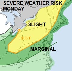
The next cold front wil approach on Monday and ahead of it you can expect hot and more humid conditions. Highs will reach into the 90s in many locations. The table is set for thunderstorms but once again it will be a battle to see where and how the severe weather sets up. The Storm Prediction Center of the National Weather Service is placing a large area of the Middle Atlantic States & the Northeast at risk for severe weather.
SEVERE WEATHER THREAT LATE MONDAY
STORM PREDICTION CENTER OUTLOOK

The satellite loop tonight shows no issues to worry about as we have clear skies though some high clouds are going by to our north. We are making a transition over to more humid air on Monday as the flow becomes more southwest ahead of the cold front.
SEVERE WEATHER THREAT LATE MONDAY
SATELLITE LOOP

Radars tonight are very quiet and we don’t anticipate any rain here until late in the day or evening Monday along coastal areas. Thunderstorms inland will arrive in the mid to late afternoon across Eastern Pennsylvania and northern areas of the Hudson Valley and then gradually moving southeastward from there.
SEVERE WEATHER THREAT LATE MONDAY
RADAR LOOPS


Tuesday Wednesday Outlook
Once the front passes dry air will move in for Tuesday and Wednesday with sunshine and lower humidity with highs in the 80s.
FiOS1 News Weather Forecast For Long Island
FiOS1 News Weather Forecast For New Jersey
FiOS1 News Weather Forecast For Hudson Valley
NATIONAL WEATHER SERVICE SNOW FORECASTS
LATEST JOESTRADAMUS ON THE LONG RANGE
Weather App

Don’t be without Meteorologist Joe Cioffi’s weather app. It is really a meteorologist app because you get my forecasts and my analysis and not some automated computer generated forecast based on the GFS model. This is why your app forecast changes every 6 hours. It is model driven with no human input at all. It gives you an icon, a temperature and no insight whatsoever.
It is a complete weather app to suit your forecast needs. All the weather information you need is right on your phone. Android or I-phone, use it to keep track of all the latest weather information and forecasts. This weather app is also free of advertising so you don’t have to worry about security issues with your device. An accurate forecast and no worries that your device is being compromised.
Use it in conjunction with my website and my facebook and twitter and you have complete weather coverage of all the latest weather and the long range outlook. The website has been redone and upgraded. Its easy to use and everything is archived so you can see how well Joe does or doesn’t do when it comes to forecasts and outlooks.
Just click on the google play button or the apple store button on the sidebar for my app which is on My Weather Concierge. Download the app for free. Subscribe to my forecasts on an ad free environment for just 99 cents a month.
Get my forecasts in the palm of your hand for less than the cost of a cup of Joe!

MENTION JOE CIOFFI AND GET A 5% DISCOUNT


