SEVERE WEATHER THREAT EXTENDED EASTWARD
[brid video=”55063″ player=”6390″ title=”Severe Weather Threat 07182016″]
SEVERE WEATHER THREAT EXTENDED EASTWARD
The Storm Prediction Center of the National Weather Service has extended the area of “Slight Risk” for severe weather to cover all of New Jersey, New York City, The Western half of Connecticut, all of the Hudson Valley and all of Pennsylvania and much of upstate New York and New England.
STORM PREDICTION CENTER FORECAST
SEVERE WEATHER THREAT EXTENDED EASTWARD

Radar is showing a developing area of showers and Thunderstorms in Western Pennsylvania moving eastward and there are already some strong cells that have developed along the Pennsylvania New York State border. These look to be moving along at a decent clip and should arrive here in Eastern Pennsylvania and Western New Jersey sometime during mid afternoon. For now the local radars remain quiet.


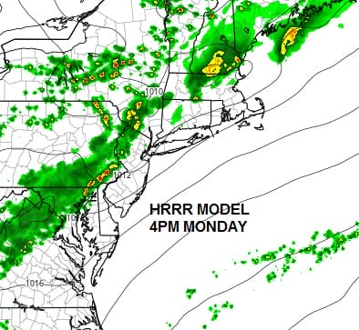
 All of the short range models have the depiction of the thunderstorm area all wrong this morning so it doesn’t lead to great confidence in what they say for this afternoon. All models weaken storms as they move through this evening. The HRRR model has the probably the least weakest view.
SEVERE WEATHER THREAT EXTENDED EASTWARD HRRR MODEL

Honestly I’m not sure sure they will weaken as indicated. The dynamics are actually supportive for thunderstorms through midnight at least. the atmosphere is very unstable especially from New York City southward, the marine influence is minimal. I think the best approach here is to watch the radar and see how it all plays out. The risk for strong thunderstorms is definitely there.
JOESTRADAMUS HURRICANE SEASON GUEST FORECAST
FiOS1 News Weather Forecast For Long Island
FiOS1 News Weather Forecast For New Jersey
FiOS1 News Weather Forecast For Hudson Valley
NATIONAL WEATHER SERVICE SNOW FORECASTS
LATEST JOESTRADAMUS ON THE LONG RANGE
Weather App

Don’t be without Meteorologist Joe Cioffi’s weather app. It is really a meteorologist app because you get my forecasts and my analysis and not some automated computer generated forecast based on the GFS model. This is why your app forecast changes every 6 hours. It is model driven with no human input at all. It gives you an icon, a temperature and no insight whatsoever.
It is a complete weather app to suit your forecast needs. All the weather information you need is right on your phone. Android or I-phone, use it to keep track of all the latest weather information and forecasts. This weather app is also free of advertising so you don’t have to worry about security issues with your device. An accurate forecast and no worries that your device is being compromised.
Use it in conjunction with my website and my facebook and twitter and you have complete weather coverage of all the latest weather and the long range outlook. The website has been redone and upgraded. Its easy to use and everything is archived so you can see how well Joe does or doesn’t do when it comes to forecasts and outlooks.
Just click on the google play button or the apple store button on the sidebar for my app which is on My Weather Concierge. Download the app for free. Subscribe to my forecasts on an ad free environment for just 99 cents a month.
Get my forecasts in the palm of your hand for less than the cost of a cup of Joe!

MENTION JOE CIOFFI AND GET A 5% DISCOUNT