
Severe Weather Threat Friday
No Severe Weather Threat Today
Severe Weather Threat Friday
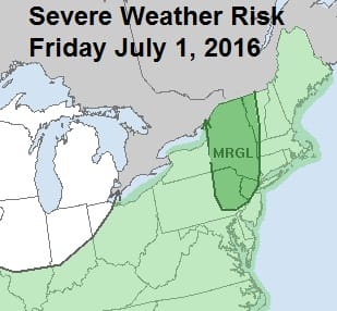
First off there is no severe weather threat for today as the map below indicates. The Storm Prediction Center has a risk for general thunderstorm activity up to New York City, Long Island & Eastern Pennsylvania however if one should pop up this afternoon it will be isolated an I did not think it was worth mentioning in the forecast.

We can see the beginnings of the next cold front beginning to approach as it swings out of the upper midwest. There is also some tropical moisture evident on the satellite loop in the Carolinas that is building up and may get involved with this front on Friday. It might be enough to juice up thunderstorms a bit so the Storm Prediction Center has placed New Jersey, Eastern Pennsylvania, and New York City under a marginal risk for severe weather. Long Island is as usual under a thunderstorm threat but not under the marginal risk area at the moment.
Severe Weather Threat Friday
As for today, no worries. We have dry air, lots of sunshine and temperatures in the 80s. I suppose it is possible that an isolated small thunderstorm could develop and if it happens I think the risk would be inland in Central and Southern New Jersey just west of where ever the sea breeze sets up. Usually these cells are small and isolated. For the broad area no issues.


Severe Weather Threat Friday
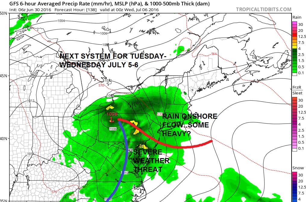
This cold front coming Friday will move offshore Friday night. There are no changes to the weekend forecast which is dry with at least some sunshine each day right through Monday the 4th Of July. Next Tuesday will bring the next chance for rain and thunderstorms with low pressure coming out of the Ohio Valley and an approaching cold front.
JOESTRADAMUS HURRICANE SEASON GUEST FORECAST
FiOS1 News Weather Forecast For Long Island
FiOS1 News Weather Forecast For New Jersey
FiOS1 News Weather Forecast For Hudson Valley
NATIONAL WEATHER SERVICE SNOW FORECASTS
LATEST JOESTRADAMUS ON THE LONG RANGE
Weather App

Don’t be without Meteorologist Joe Cioffi’s weather app. It is really a meteorologist app because you get my forecasts and my analysis and not some automated computer generated forecast based on the GFS model. This is why your app forecast changes every 6 hours. It is model driven with no human input at all. It gives you an icon, a temperature and no insight whatsoever.
It is a complete weather app to suit your forecast needs. All the weather information you need is right on your phone. Android or I-phone, use it to keep track of all the latest weather information and forecasts. This weather app is also free of advertising so you don’t have to worry about security issues with your device. An accurate forecast and no worries that your device is being compromised.
Use it in conjunction with my website and my facebook and twitter and you have complete weather coverage of all the latest weather and the long range outlook. The website has been redone and upgraded. Its easy to use and everything is archived so you can see how well Joe does or doesn’t do when it comes to forecasts and outlooks.
Just click on the google play button or the apple store button on the sidebar for my app which is on My Weather Concierge. Download the app for free. Subscribe to my forecasts on an ad free environment for just 99 cents a month.
Get my forecasts in the palm of your hand for less than the cost of a cup of Joe!
![]()

MENTION JOE CIOFFI AND GET A 5% DISCOUNT