
First Pacific Tropical Storm Possible
First Pacific Tropical Storm Possible This Weekend
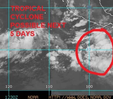
The Atlantic Tropical Storm Season is off with a bang as we have already moved through 3 named storms since late May (excluding Hurricane Alex back in January). However the Pacific side which had a banner year in 2015, has been remarkably silent. This is usually the case that when the Atlantic side is fired up, the Pacific side seems to be more relaxed. The season in the Eastern Pacific begins 2 weeks before the Atlantic season. However the silence is about to be broken as we are beginning to see a disturbance off the Coast of Mexico taking shape.
First Pacific Tropical Storm Possible
Satellite Picture from 8am Thursday June 30th
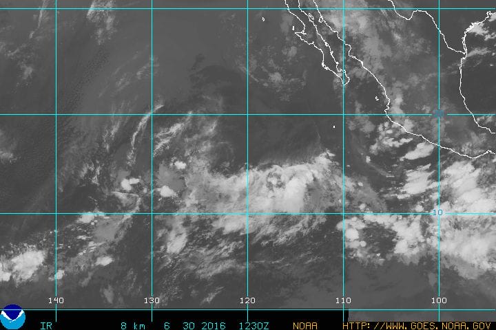
The tropical convergence zone in the Pacific is beginning to get active with clouds stretching from the coast of Mexico westward to almost 140 degrees west. It is on the eastern edge of this that a disturbance is going to organize over thew weekend. Weather models have been suggesting that this could become a hurricane in the Pacific early next week as it moves west northwestward or northwestward off shore. Typically these things run their course and don’t usually threaten Mexico this time of year. The National Hurricane Center rates this a 70 percent chance of developing into a tropical storm.
Gulf of Mexico Caribbean Western Atlantic Satellite Loop

On the Atlantic side things are quiet across much of the Tropical Atlantic westward to the Caribbean Sea and Gulf of Mexico. No tropical cyclone development is indicated over the next 5 days. Usually the period from late June to mid July is a quiet time on the Atlantic side.

JOESTRADAMUS HURRICANE SEASON GUEST FORECAST
FiOS1 News Weather Forecast For Long Island
FiOS1 News Weather Forecast For New Jersey
FiOS1 News Weather Forecast For Hudson Valley
NATIONAL WEATHER SERVICE SNOW FORECASTS
LATEST JOESTRADAMUS ON THE LONG RANGE
Weather App

Don’t be without Meteorologist Joe Cioffi’s weather app. It is really a meteorologist app because you get my forecasts and my analysis and not some automated computer generated forecast based on the GFS model. This is why your app forecast changes every 6 hours. It is model driven with no human input at all. It gives you an icon, a temperature and no insight whatsoever.
It is a complete weather app to suit your forecast needs. All the weather information you need is right on your phone. Android or I-phone, use it to keep track of all the latest weather information and forecasts. This weather app is also free of advertising so you don’t have to worry about security issues with your device. An accurate forecast and no worries that your device is being compromised.
Use it in conjunction with my website and my facebook and twitter and you have complete weather coverage of all the latest weather and the long range outlook. The website has been redone and upgraded. Its easy to use and everything is archived so you can see how well Joe does or doesn’t do when it comes to forecasts and outlooks.
Just click on the google play button or the apple store button on the sidebar for my app which is on My Weather Concierge. Download the app for free. Subscribe to my forecasts on an ad free environment for just 99 cents a month.
Get my forecasts in the palm of your hand for less than the cost of a cup of Joe!
![]()