Severe Weather Threat Diminishes
Severe Weather Threat Diminishes
While there are still some showers and thunderstorms around on the radar, the threat for severe weather overnight has diminished considerably. While the odd thunderstorm could still impact some areas the widespread outbreak from earlier this evening has ended. There still may be a few showers or a heavier downpour in some areas overnight but weather conditions will improve on Tuesday. The satellite loop shows the upper low and storm system lifting northward through the Great Lakes and into Southeastern Canada. This should begin to drive dry cooler air over the area over the next few days.
SATELLITE LOOP

REGIONAL RADAR

LOCAL RADAR NEW YORK CITY

LOCAL RADAR PHILADELPHIA


Radars will see activity gradually diminish over night. Skies Tuesday will become partly sunny with highs reaching the upper 60s and lower 70s in most places. Wednesday looks good with some sunshine breezy and cool conditions with highs in the low to mid 60s.
GFS RAINFALL FORECAST FOR THURSDAY NIGHT THROUGH FRIDAY EVENING
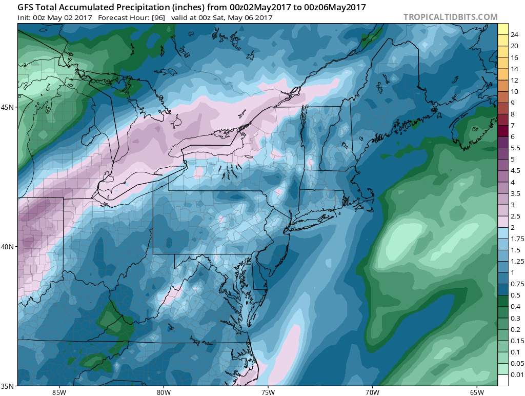
Weather conditions will begin to deteriorate on Thursday with arriving clouds. Rain will develop Thursday night and heavy rain is forecast for Friday as low pressure comes out of the Southern Plains and heads up the Appalachians. Up to a couple of inches of rain is forecast based on latest model runs which remain very consistent. This system for the end of the week begins a prolonged period of clouds and showers that we will be dealing with over the weekend and into next week in response to a strong block that is developing. This will slow weather systems down to an absolute crawl.
 GET JOE A CIGAR IF YOU LIKE

LANDSCAPE COMPANIES FOR YOUR NEEDS
LONG ISLAND ROCKLAND COUNTY Connecticut

![]()

ROCKLAND COUNTY TRI STATE SNOW REMOVAL JOHNSTOWN PA


FiOS1 News Weather Forecast For Long Island
FiOS1 News Weather Forecast For New Jersey
FiOS1 News Weather Forecast For Hudson Valley
NATIONAL WEATHER SERVICE SNOW FORECASTS
LATEST JOESTRADAMUS ON THE LONG RANGE
Weather App

Don’t be without Meteorologist Joe Cioffi’s weather app. It is really a meteorologist app because you get my forecasts and my analysis and not some automated computer generated forecast based on the GFS model. This is why your app forecast changes every 6 hours. It is model driven with no human input at all. It gives you an icon, a temperature and no insight whatsoever.
It is a complete weather app to suit your forecast needs. All the weather information you need is right on your phone. Android or I-phone, use it to keep track of all the latest weather information and forecasts. This weather app is also free of advertising so you don’t have to worry about security issues with your device. An accurate forecast and no worries that your device is being compromised.
Use it in conjunction with my website and my facebook and twitter and you have complete weather coverage of all the latest weather and the long range outlook. The website has been redone and upgraded. Its easy to use and everything is archived so you can see how well Joe does or doesn’t do when it comes to forecasts and outlooks.
Just click on the google play button or the apple store button on the sidebar for my app which is on My Weather Concierge. Download the app for free. Subscribe to my forecasts on an ad free environment for just 99 cents a month.
Get my forecasts in the palm of your hand for less than the cost of a cup of Joe!


