
Severe Weather Threat Again Later Today Hot Humid Thunderstorms
Severe Weather Threat Again Later Today
Hot Humid Thunderstorms
Last night’s severe weather episode across Northern New Jersey to NYC, Long Island and the Hudson Valley was one of the fiercest rounds of severe weather we have seen here in quite a long time. Numerous lightning strikes, flooding rains, damaging winds, and even some rotation in the clouds, all combining to bring the area several scary hours. We have a similar set up today as a cold front approaches so the Storm Prediction Center of the National Weather Service has us at a risk for severe weather.

Today’s round of thunderstorms could come a little earlier than yesterday as they should start firing up around midday and peaking during the afternoon. At the moment satellite and radars are quiet.
EASTERN SATELLITE

REGIONAL RADAR

LOCAL RADAR NEW YORK CITY

LOCAL RADAR PHILADELPHIA


Weather models are all rather useless at this point. Every short term model has a different idea regarding where thunderstorms develop so at this point we just forget those and watch the radars and see how things evolve. Know that the risk is there for this afternoon into tonight. Highs today will be ni the 80s to near 90 degrees. Some places in New Jersey are going to see their 4th consecutive day of 90 degree plus highs.
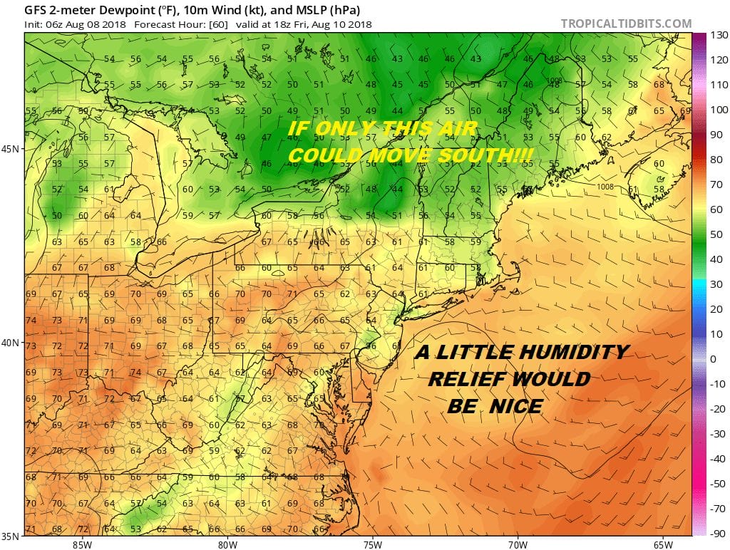
What we are all looking for is relief from the humidity and unfortunately the relief that is coming will be slight if any at all on Thursday and perhaps a shade more dew point relief Friday into Friday night. It will still be very warm Some areas like South Jersey and Southeast Pennsylvania may not see much dew point relief at all over the next few days. Look for some sunshine Thursday and Friday with highs in the 80s.
GFS FORECAST SATURDAY EVENING 08/12/2018
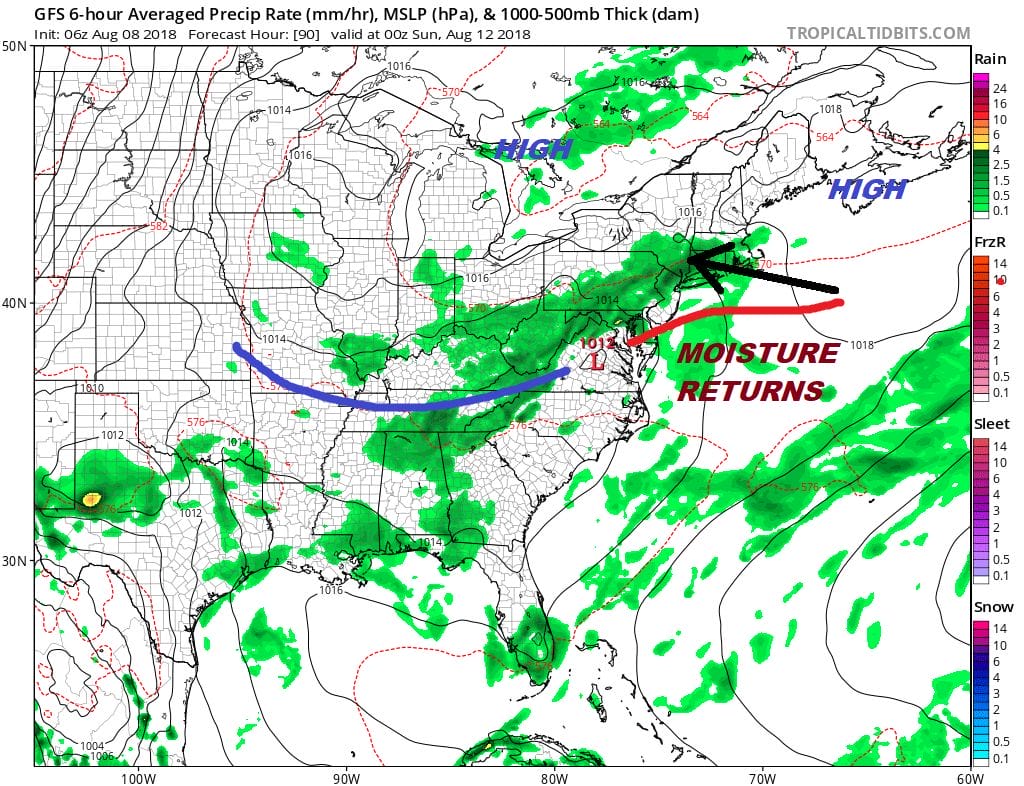
We will have issues for the weekend and into next week as a trough returns to the East similar to what we have seen twice in the last 2 weeks. Onshore flow develops Saturday with clouds and showers and there is the increasing chance for downpours Sunday and Monday in this pattern. It doesn’t rain all the time so we are not looking for washouts here but remember the risk is there every day. With the onshore flow it should hold temperatures back some but the ocean is warm now so temperatures will likely still make it into the 80s and the humidity will be climbing once again over the weekend and into next week.
GFS RAINFALL FORECAST THROUGH TUESDAY AUGUST 14, 2018
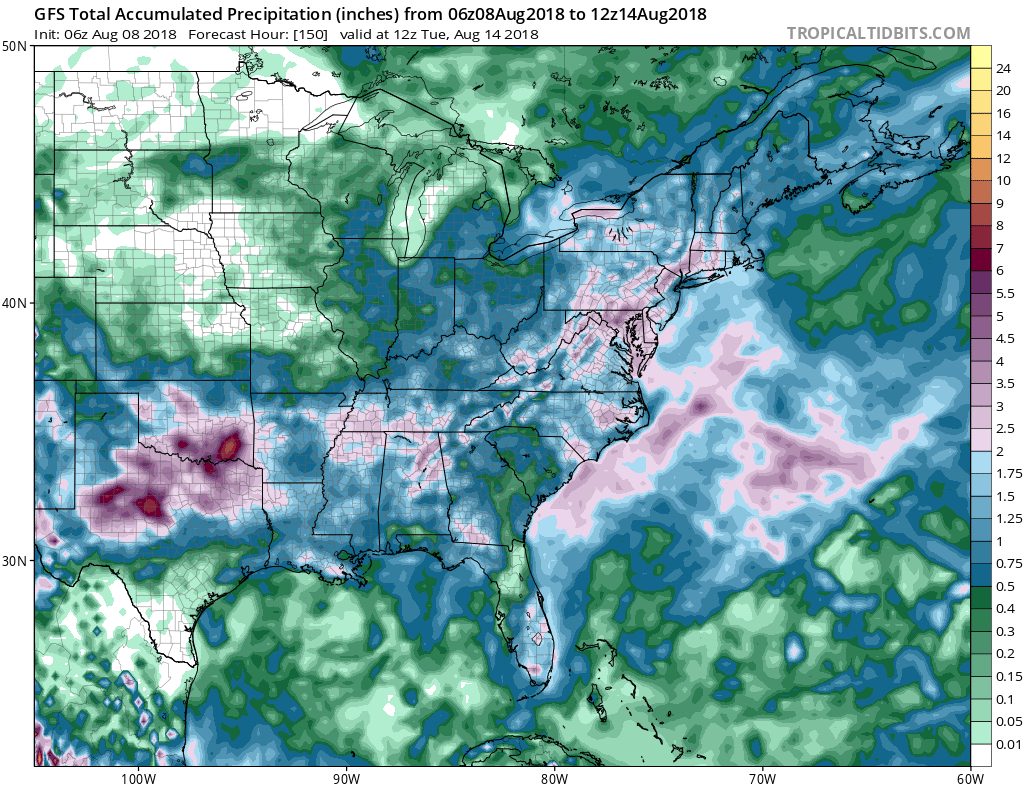
Of concern is the rainfall forecast over the next 6 days which is showing 2 to 4 inches of rain. It is always hard to pick the upside here as weather models are not good at handling specifics especially in the summer time. However the heavy rain does fall over areas which have received many inches in the last few weeks so flash flooding could become a concern if these amounts verify especially in any thunderstorms.
Please note that with regards to any tropical storms or hurricanes, should a storm be threatening, please consult your local National Weather Service office or your local government officials about what action you should be taking to protect life and property.
THANK YOU TO TROPICAL TIDBITS FOR USE OF THE WONDERFUL MAPS

LATEST JOESTRADAMUS ON THE LONG RANGE


