
Severe Weather Risks Heat Humidity Late Day Evening Thunderstorms

Weather in 5/Joe & Joe Weather Show Latest Podcast
Severe Weather Risks Heat Humidity Late Day Evening Thunderstorms
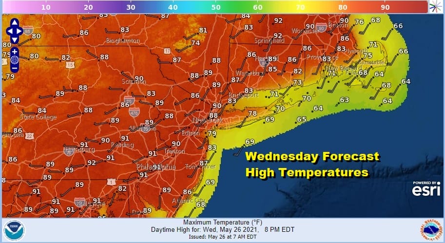
It is certainly going to be an interesting day weather wise. Very warm to hot humid air is surging up the east coast. Sunshine will gradually take over and last into the afternoon. This will be key to temperatures. Daytime heating will be a big driver of thunderstorms and severe weather later today and tonight.
For now at least the radars are quiet (as of 8am Eastern Time). A destabilized atmosphere and an upper trough moving through the Northeast set the stage for severe weather today. The Storm Prediction Center in their overnight forecast greatly expanded the slight risk zone to the east and to the south.

Marginal risk for severe weather covers even coastal areas from Delaware and Maryland to Southern and most of Southeastern New England. Sight risk runs up and down the I-95 corridor. This is a situation where there is tornado risk.
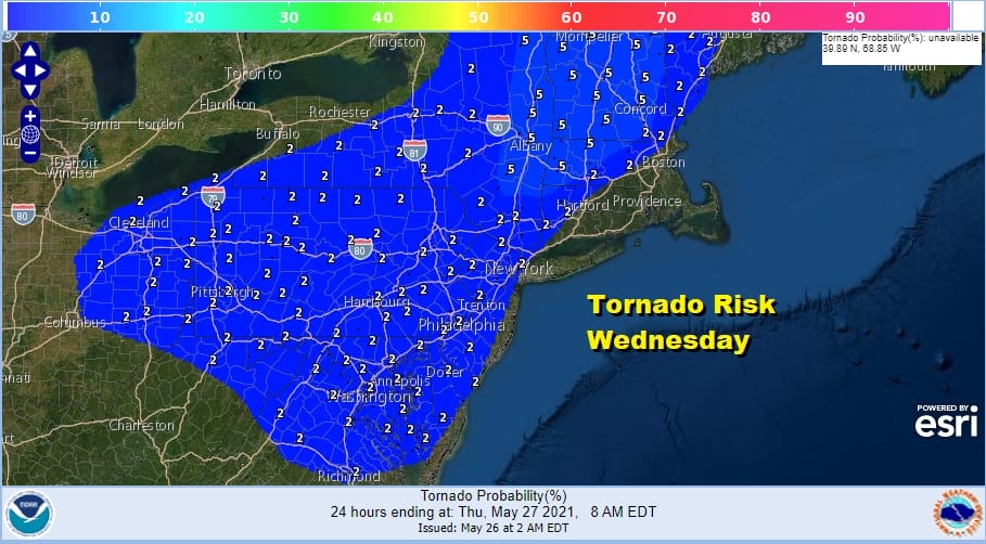
Most of the area is under a 2% tornado risk with 5% probabilities in Central New England to Eastern NY State. These numbers are the chances for a tornado within 25 miles of any point inside the risk zone. 5% is not a small number when viewed in this context.
SATELLITE

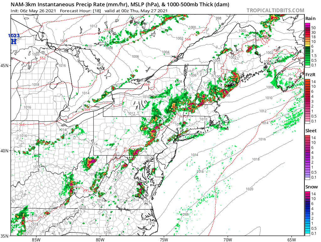
We will start to see thunderstorms develop probably after 1 or 2pm across Pennsylvania and Upstate NY with peak thunderstorm activity probably between 5 and 9pm as the move from west to east. It looks there will be thunderstorms that form out ahead of the main line.
NAM 8PM WEDNESDAY
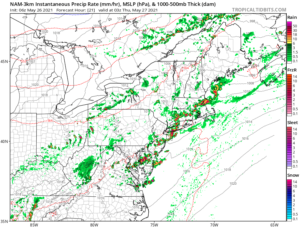
NAM 11PM WEDNESDAY
Weather conditions will improve overnight setting us up for a beautiful day Thursday with lots of sunshine, low humidity and most highs reaching into the lower 80s. Then it is on to Friday or Getaway Day ahead of the holiday weekend. It looks like rain develops during the day from west to east and lasts into the early morning hours Saturday. Temperatures Friday will be in the 60s to near 70 and then once the rain commences temperatures will fall into the 50s or even lower in some places well to the north. As far as the holiday weekend is concerned we will update the weekend outlook later today.

BE SURE TO DOWNLOAD THE FREE METEOROLOGIST JOE CIOFFI WEATHER APP &
ANGRY BEN’S FREE WEATHER APP “THE ANGRY WEATHERMAN!
MANY THANKS TO TROPICAL TIDBITS FOR THE USE OF MAPS
Please note that with regards to any severe weather, tropical storms, or hurricanes, should a storm be threatening, please consult your local National Weather Service office or your local government officials about what action you should be taking to protect life and property.


