
Severe Weather Risk Tonight Through Thursday Evening
Severe Weather Risk Tonight Through Thursday Evening
We are in the throws of a very warm/hot air mass for the next 2 1/2 days so there is the risk for severe weather tonight through Thursday evening. The satellite loop shows several upper air disturbances rotating around a strong upper air storm in Canada so as each disturbance moves through it will probably set off some scattered heavy thunderstorms. We are seeing some of those thunderstorms on the radars this evening. They are scattered and most of them seem to be concentrated over Central & Southern New Jersey. Keep an eye to the sky for threatening weather as these storms can come and go rather quickly.
SATELLITE LOOP

REGIONAL RADAR

LOCAL RADAR NEW YORK CITY

LOCAL RADAR PHILADELPHIA


No doubt that it is very warm and very humid with temperatures that reached the mid 80s to near 90 today. We will do it all over again on Wednesday with the chance for late thunderstorms.
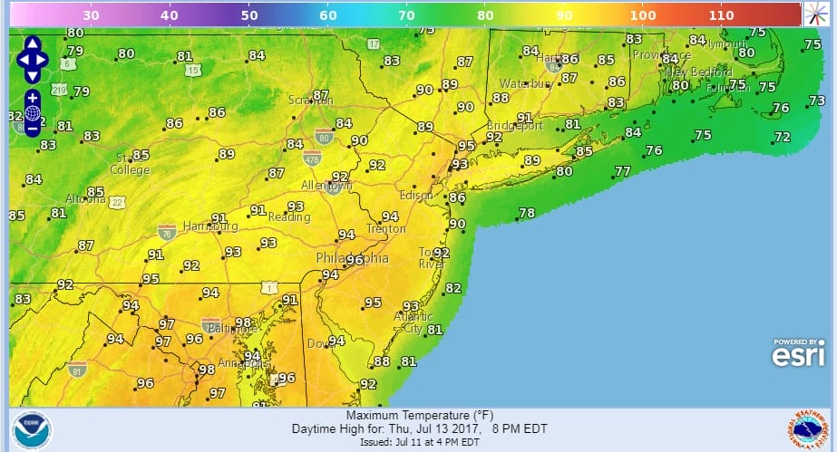
Thursday will be the hottest day of the stretch with highs in many areas reaching the low to middle 90s.
GFS RAIN FORECAST FOR FRIDAY

Friday brings about a change with a front stalled to our south and a wave developing on it. This is going to put us in clouds, an onshore flow and probably some rain. Temperatures Friday may hover in the low to mid 70s at best because of the wind off the ocean. Then improvement should come for the weekend with sunshine and clouds Saturday and mostly sunny skies on Sunday. Humidity over the weekend will be trending lower.
 GET JOE A CIGAR IF YOU LIKE

LANDSCAPE COMPANIES FOR YOUR NEEDS
LONG ISLAND ROCKLAND COUNTY Connecticut

![]()

ROCKLAND COUNTY TRI STATE SNOW REMOVAL JOHNSTOWN PA


FiOS1 News Weather Forecast For Long Island
FiOS1 News Weather Forecast For New Jersey
FiOS1 News Weather Forecast For Hudson Valley
NATIONAL WEATHER SERVICE SNOW FORECASTS
LATEST JOESTRADAMUS ON THE LONG RANGE
Weather App

Don’t be without Meteorologist Joe Cioffi’s weather app. It is really a meteorologist app because you get my forecasts and my analysis and not some automated computer generated forecast based on the GFS model. This is why your app forecast changes every 6 hours. It is model driven with no human input at all. It gives you an icon, a temperature and no insight whatsoever.
It is a complete weather app to suit your forecast needs. All the weather information you need is right on your phone. Android or I-phone, use it to keep track of all the latest weather information and forecasts. This weather app is also free of advertising so you don’t have to worry about security issues with your device. An accurate forecast and no worries that your device is being compromised.
Use it in conjunction with my website and my facebook and twitter and you have complete weather coverage of all the latest weather and the long range outlook. The website has been redone and upgraded. Its easy to use and everything is archived so you can see how well Joe does or doesn’t do when it comes to forecasts and outlooks.
Just click on the google play button or the apple store button on the sidebar for my app which is on My Weather Concierge. Download the app for free. Subscribe to my forecasts on an ad free environment for just 99 cents a month.
Get my forecasts in the palm of your hand for less than the cost of a cup of Joe!


