
Severe Weather Risk This Evening And Late Thursday
Nice Weather Low Humidity Arrives Friday & The Labor Day Weekend
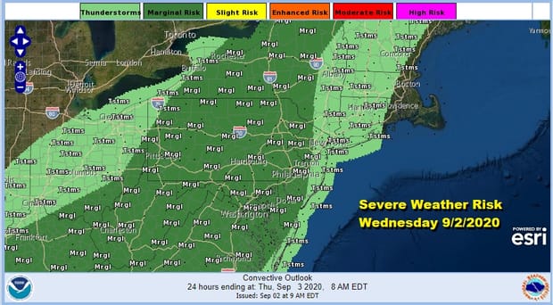
The rain and showers from this morning have moved away to the northeast. Now we see warmer and more humid air beginning to arrive. We still have a lot of clouds around the area going into this evening however some sun has broken through the clouds in parts of Southern New Jersey and Southeastern Pennsylvania southward. We could see some scattered thunderstorms bubble up this evening and the Prediction Center has a marginal risk of severe weather indicated mostly away from coastal areas.
SATELLITE

REGIONAL RADAR

We are seeing scattered showers around on the radar and we will watch for those scattered thunderstorms popping up this evening. Areas along the coast should not be at risk for severe weather as the marine layer stubbornly tries to hold on.
LOCAL RADAR NEW YORK CITY

LOCAL RADAR PHILADELPHIA


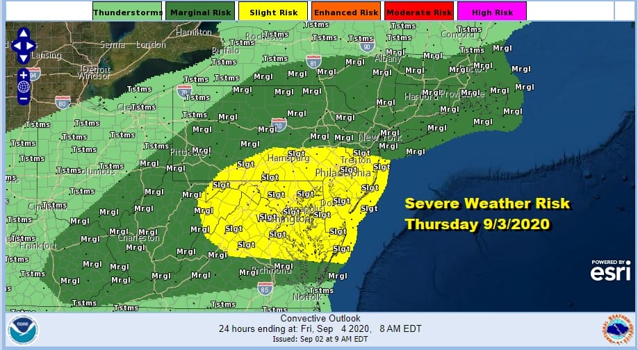
Warm and humid conditions continue tonight with lows in the upper 60s to mid 70s. Thursday look for very warm and humid conditions with some sunshine. Highs will be in the mid to upper 80s. A cold front will be approaching and that could set off some thunderstorms Thursday evening. The Storm Prediction Center has a marginal to slight risk for severe weather for Thursday.
There are no changes in the outlook for the Labor Day Weekend. Starting Friday with the front pushing offshore, it will likely start off warm and humid with some leftover clouds but we should see increasing amounts of sunshine as the day wears on along with a gradual lowering of humidity. Highs will be in the 80s but dew points will drop into the 50s during the afternoon.

The story for the weekend will be high pressure building in for all three days. We will have lots of sunshine with low humidity for both Saturday and Sunday. Highs both days will be in the 70s. Nighttime lows both days will be in the 50s to lower 60s. On Monday Labor Day you will notice a cold front getting close but it doesn’t get here until sometime Monday night or early Tuesday morning. It will be warmer Monday with highs into the 80s but the humidity, while higher, will still be relatively reasonable. No rain is forecast into Monday evening as the cold front takes longer to get here.
BE SURE TO DOWNLOAD THE FREE METEOROLOGIST JOE CIOFFI WEATHER APP &
ANGRY BEN’S FREE WEATHER APP “THE ANGRY WEATHERMAN!
MANY THANKS TO TROPICAL TIDBITS FOR THE USE OF MAPS
Please note that with regards to any severe weather, tropical storms, or hurricanes, should a storm be threatening, please consult your local National Weather Service office or your local government officials about what action you should be taking to protect life and property.


