Severe Weather Risk Saturday Cloudy Damp Mother’s Day
Severe Weather Risk Saturday Cloudy Damp Mother’s Day
After last night’s round of thunderstorms we are seeing a very nice finish to the week with sunshine just about everywhere and nothing more than some passing clouds. This is a great way to finish off the week and temperatures should reach the upper 60s to some middle 70s just about everywhere this afternoon. The satellite picture doesn’t show much going on at the moment though late this afternoon some clouds will begin pushing in from the west.
EASTERN US SATELLITE

REGIONAL RADAR

The next frontal system begins its approach tonight as clouds increase. During the morning hours surrounding daybreak we will see the first of two rounds of showers and downpours. These will play their way through and the by mid morning and continuing until mid afternoon Saturday we will likely see a stretch of dry weather with warm and humid conditions developing. A warm sector will likely set up and this opens us up to second round of downpours and thunderstorms in the late afternoon and evening.
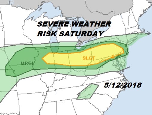
SEVERE WEATHER RISK SATURDAY MAY 12, 2018

I think that there is a fairly good chance of seeing the slight risk area extending further east to include coastal areas. The front is coming down from the north so there may not be a marine influence this time around. Temperatures Saturday are going to be tough to figure.
SATURDAY FORECAST HIGH TEMPERATURES
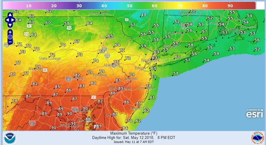
While temperatures in Southern New Jersey & Southeastern Pennsylvania will be reaching the mid to upper 80s..temperatures in North Jersey, the Hudson Valley & Connecticut probably won’t be getting out of the 50s or lower 60s! This certainly sets up a very ripe boundary for thunderstorms south of the frontal boundary so where it ultimately sets up will be very important indeed to the strength of thunderstorms late in the day. North of NYC into the Hudson Valley and Connecticut it would see the threat would be lower unless the frontal boundary buckles to the north.
SUNDAY FORECAST HIGH TEMPERATURES
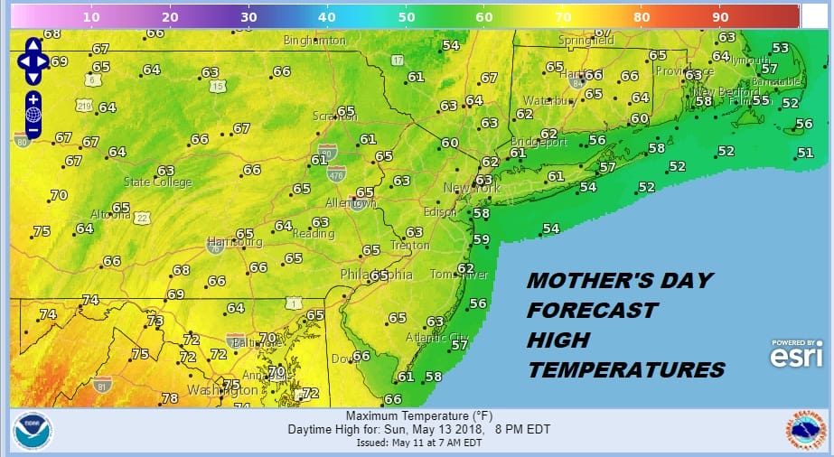
Sunday with the frontal boundary to the south it will be a cloudy cool day overall with highs mostly in the 60s. Oddly enough areas north of NYC in the Hudson Valley & Connecticut are likely to be a little warmer Sunday than Saturday! Some on and off showers are possible. it won’t be a picture perfect Sunday but it won’t be a rain out either though the front needs to be watched in case a wave develops on it at the last minute. Weather conditions should improve somewhat on Monday. The weather pattern looks to turn rather showery and humid later next week as moist tropical air makes its way up the East Coast.
 GET JOE A CIGAR IF YOU LIKE

FiOS1 News Weather Forecast For Long Island
FiOS1 News Weather Forecast For New Jersey
FiOS1 News Weather Forecast For Hudson Valley


