Severe Weather Risk Overnight Easter Weekend Outlook

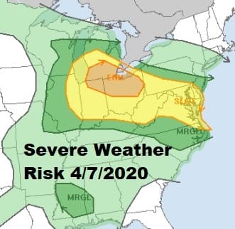
We managed to squeeze out a nice day from start to finish in much of the Northeast but clouds are increasing tonight and there will be some showers and perhaps a thunderstorm or two to deal with. The Storm Prediction Center hasn’t changed their outlook for severe weather tonight keeping the risk in New Jersey from Route 195 south and in general south of Route 78 in Pennsylvania. They did raise risk to “enhanced” in parts of Ohio and Michigan. This area saw temperatures shoot up into the middle and upper 70s today. We however stayed in the 60s.
SATELLITE

REGIONAL RADAR

Regional radar is showing some heavy thunderstorm activity moving off the Delmarva Peninsula with other scattered thunderstorms in Virginia and North Carolina. Other showers are moving east southeast across Western NY and Western Pennsylvania and they should be starting to pop up on the local radars in the next few hours.
LOCAL RADAR NEW YORK CITY

LOCAL RADAR PHILADELPHIA


Showers and a thunderstorm will play through the overnight hours into daybreak and then come to an end. After that weather conditions on Wednesday will depend on location. From NYC north and east it may be a struggle to clear out thanks to clouds and a northeast wind. Temperatures will be in the low 60s around NYC and nearby with 50s to the east.
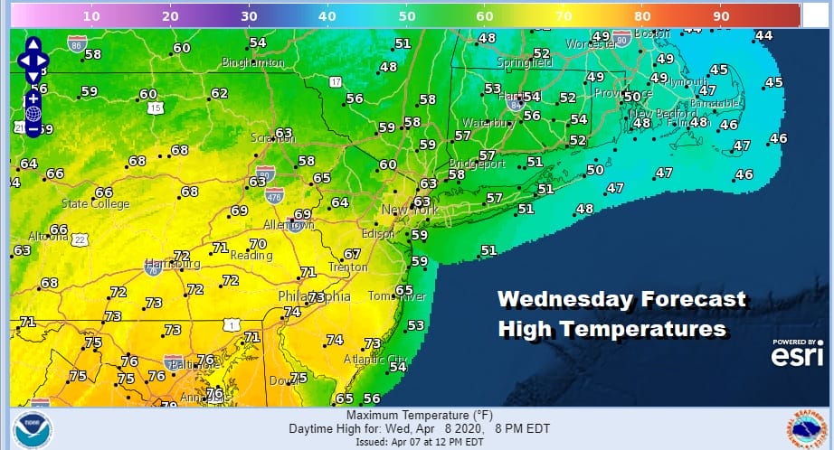
South and west of NYC some sunshine and a west wind will take over and highs will probably reach into the 70s especially from Philadelphia south and southwest. Then the next cold front arrives Thursday with showers and perhaps a thunderstorm Thursday morning into the afternoon.

Leftover clouds will follow Thursday afternoon with highs in the 60s. Friday will be windy and chilly with clouds and some sun along with the chance for a passing shower. Highs will be just in the 50s. Some snow showers are possible well north and west into Upstate NY and New England.

The weekend will be on the chilly side especially Saturday which will start in the 30s and finish just into the 50s with some sunshine. Easter Sunday look for arriving clouds with highs back into the 60s. Weather models are showing low pressure heading from the Southern Plains to the Appalachians and into the Northeast. Rain could arrive as early as late Easter Sunday afternoon or evening. Rain heavy at times is likely Sunday night into Monday morning before weather conditions improve afterwards.
BE SURE TO DOWNLOAD THE FREE METEOROLOGIST JOE CIOFFI WEATHER APP &
ANGRY BEN’S FREE WEATHER APP “THE ANGRY WEATHERMAN!
MANY THANKS TO TROPICAL TIDBITS FOR THE USE OF MAPS
Please note that with regards to any severe weather, tropical storms, or hurricanes, should a storm be threatening, please consult your local National Weather Service office or your local government officials about what action you should be taking to protect life and property.


