Severe Weather Risk Late Afternoon & Evening
Severe Weather Risk Late Afternoon & Evening
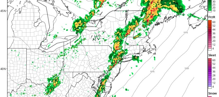
We are watching the approaching cold front and ahead of it we have lots of clouds warm and humid conditions. We also have the marine layer affecting south facing shoreline today restricting visibility and creating some low clouds and foggy conditions. As of midday we are seeing the beginnings of a line of thunderstorms developing in West Central Pennsylvania and these will grow stronger as the afternoon wears on. Whether the line survives in peak strength when it reaches the coast remains to be seen as short range models do show the line peaking between 6pm & 7pm as they cross New Jersey & head for the coast.

As of 1pm no severe thunderstorm watches have been posted by the Storm Prediction Center.
SATELLITE LOOP

REGIONAL RADAR

LOCAL RADAR NEW YORK CITY

LOCAL RADAR PHILADELPHIA


Radars are showing a few scattered showers around but on the whole it is dry for most of the area. Temperatures along the immediate coast are in the 70s while inland temperatures are in the lower 80s. Clouds will limit the upside today as far as temperatures go.
Once thunderstorms are done this evening we will see improving weather conditions for Sunday with sunshine and a west wind so highs will reach the mid 80s to near 90 degrees with slightly lower humidity. Monday and Tuesday remains on course. Monday will be mostly sunny until mid afternoon when another front passes. There could be an isolated shower or thunderstorm with that. Highs in the 80s to near 90…then it is low humidity and sunshine for Tuesday with highs in the upper 70s and lower 80s. 4th of July fireworks Tuesday night will come with a clear skies and pleasant conditions.
 GET JOE A CIGAR IF YOU LIKE

Weather App

Don’t be without Meteorologist Joe Cioffi’s weather app. It is really a meteorologist app because you get my forecasts and my analysis and not some automated computer generated forecast based on the GFS model. This is why your app forecast changes every 6 hours. It is model driven with no human input at all. It gives you an icon, a temperature and no insight whatsoever.
It is a complete weather app to suit your forecast needs. All the weather information you need is right on your phone. Android or I-phone, use it to keep track of all the latest weather information and forecasts. This weather app is also free of advertising so you don’t have to worry about security issues with your device. An accurate forecast and no worries that your device is being compromised.
Use it in conjunction with my website and my facebook and twitter and you have complete weather coverage of all the latest weather and the long range outlook. The website has been redone and upgraded. Its easy to use and everything is archived so you can see how well Joe does or doesn’t do when it comes to forecasts and outlooks.
Just click on the google play button or the apple store button on the sidebar for my app which is on My Weather Concierge. Download the app for free. Subscribe to my forecasts on an ad free environment for just 99 cents a month.
Get my forecasts in the palm of your hand for less than the cost of a cup of Joe!


