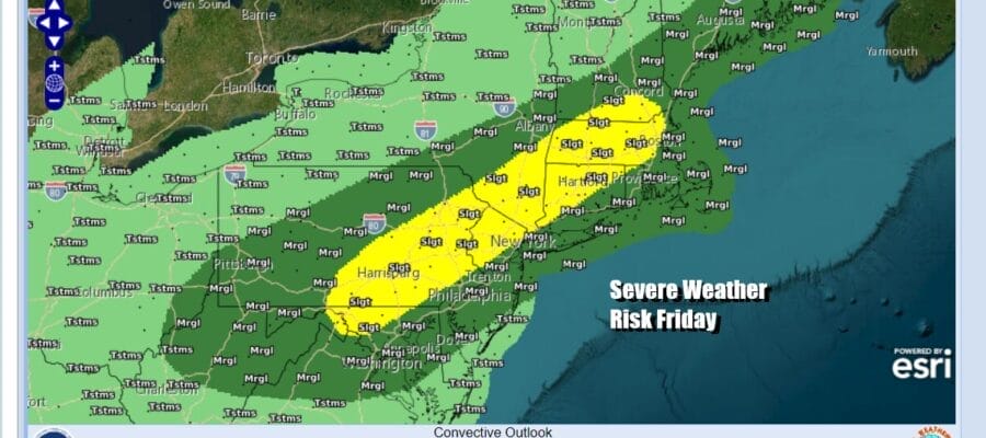
Severe Weather Risk Friday Ahead of a Nice Father’s Day Weekend
Early Summer Heatwave Next Week

Severe Weather Risk Friday Ahead of a Nice Father’s Day Weekend
Early Summer Heatwave Next Week
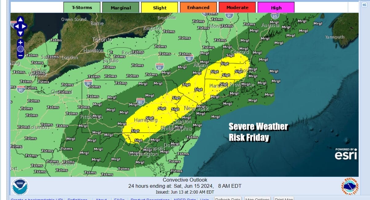
We seem to be in a transition from spring to summer matching up close to the calendar. Two big changes coming will usher that change. The first will be late Friday into Friday night where we have the risk for showers and thunderstorms and severe weather. The Storm Prediction Center has a slight risk for severe weather for much of Eastern Pennsylvania to Southern New England. Then after a nice weekend, a heatwave begins Monday that could last all of next week.

Temperatures will be heading higher today under mainly sunny skies. We are out of upper troughs moving through with clouds and the satellite loops show cloud free conditions in much of the Eastern US. Temperatures this afternoon will reach the low and middle 80s inland. Coastal areas will be a little cooler as local sea breezes develop during the afternoon. Radars are nice and quiet and will remain so into the first part of Friday. Humidity levels will still be subdued today but they will start to rise overnight.
SATELLITE WITH LIGHTNING STRIKES

WEATHER RADAR

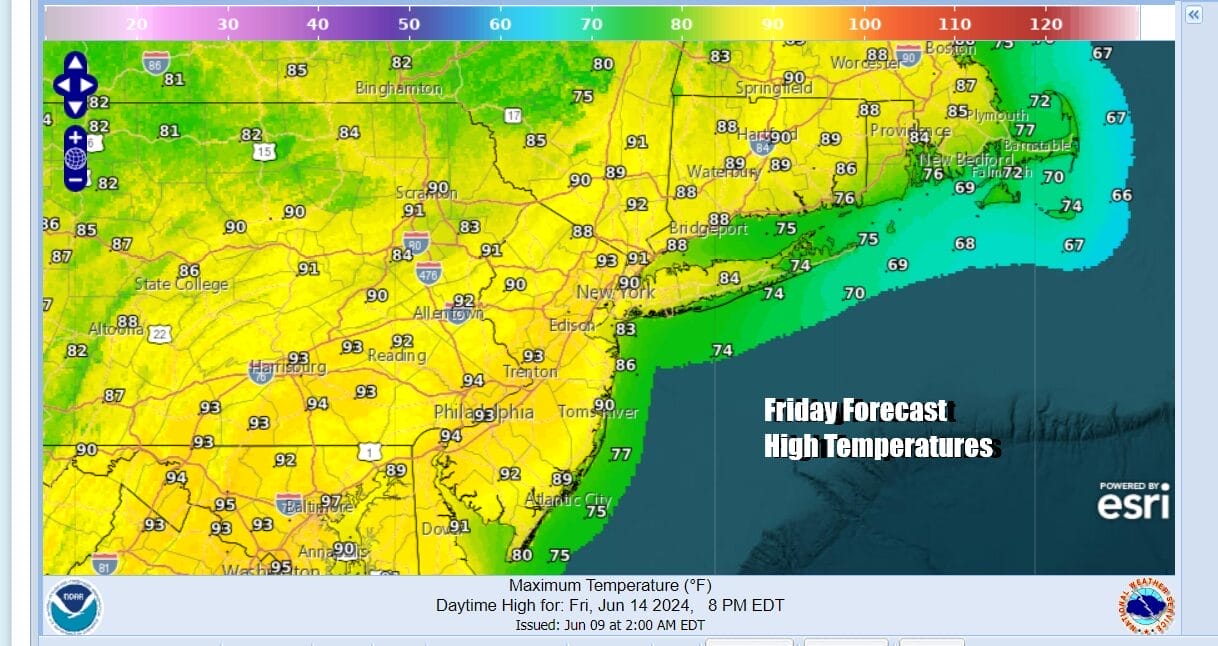
Friday will likely be the first day this season where we see highs reaching 90 degrees or a little higher in many inland areas. We will see sunshine into the afternoon and dew points will be climbing into the 60s so you will notice the increase in humidity levels and discomfort. Later in the day as a cold front and strong upper trough approaches from the northwest, clouds will develop.
During the afternoon thunderstorms will develop across Pennsylvania and most models are showing a rather robust line of thunderstorms forming and moving eastward. They will likely arrive in Western New Jersey in the late afternoon and evening and then continue to progress eastward Friday night.

Coastal areas might see the storms weaken thanks to the wind coming in from off the ocean. The front is going to keep on moving which is good news. Weather conditions will improve during the early morning hours as high pressure starts to build in from the northwest.

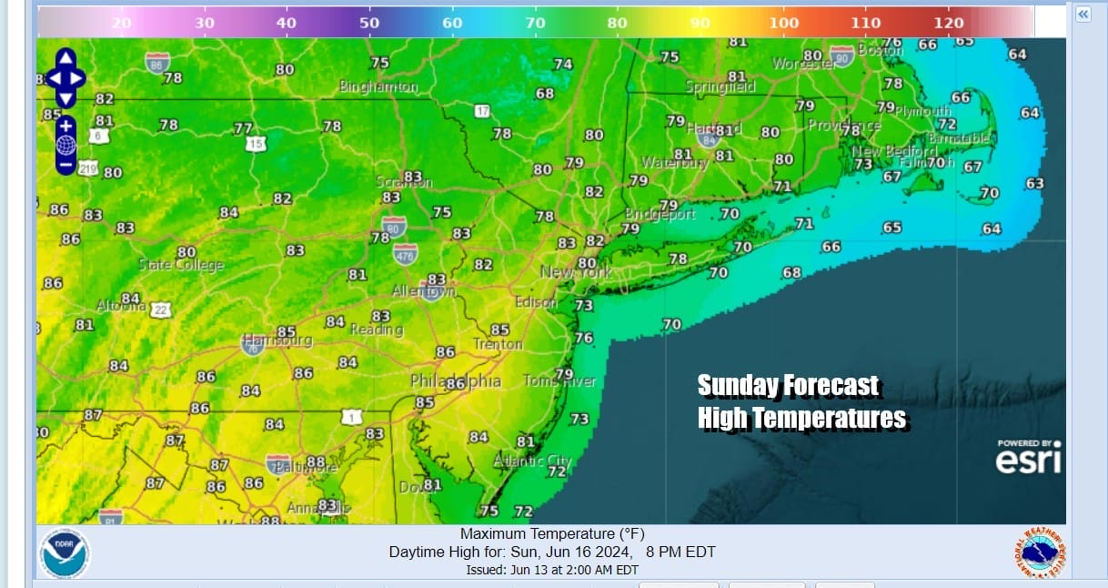
The weekend will be very nice and we see low humidity and sunshine for both Saturday and Sunday. The weekend will be rain free and we should see nothing more than some passing clouds on Saturday and perhaps a few wispy high clouds Sunday. Saturday and Sunday highs will reach into the 80s in most places with some cooler spots in the upper 70s to near 80.
Beginning Monday, a ridge building in the Eastern US will bring heat for much if not all of next week. At the very least we will be stringing together at least 3 days of 90 degree plus highs and that could easily get extending to 5 or 6 days depending on when the next cold front arrives. Fronts dropping southward from Eastern Canada will hit the ridge and likely fall apart bringing only limited relief to coastal areas perhaps. We will need to examine that prospect next week. Shower and thunderstorm activity should be limited next week if we see any at all given the stable nature of the ridge in the Eastern US. Monday highs will reach the low 90s away from the coast. Tuesday and Wednesday we could see highs in the low to middle 90s.
BE SURE TO DOWNLOAD THE FREE METEOROLOGIST JOE CIOFFI WEATHER APP &
ANGRY BEN’S FREE WEATHER APP “THE ANGRY WEATHERMAN!
MANY THANKS TO TROPICAL TIDBITS FOR THE USE OF MAPS
Please note that with regards to any severe weather, tropical storms, or hurricanes, should a storm be threatening, please consult your local National Weather Service office or your local government officials about what action you should be taking to protect life and property.
(Amazon is an affilate of Meteorologist Joe Cioffi & earns commissions on sales.)


