
Severe Weather Risk Again Today
Elsa Will Move Up East Coast Rain Late Thursday Night Into Friday

Weather in 5/Joe & Joe Weather Show Latest Podcast
Severe Weather Risk Again Today
Elsa Will Move Up East Coast Rain Late Thursday Night Into Friday
Yesterday’s severe weather episode certainly lived up to expectations and created all sorts of havoc with down trees and powerlines in many locations. Coastal areas that have missed other thunderstorm episodes bore the brunt of this one as the upper trough coming down in a northwest flow makes for maximum instability.
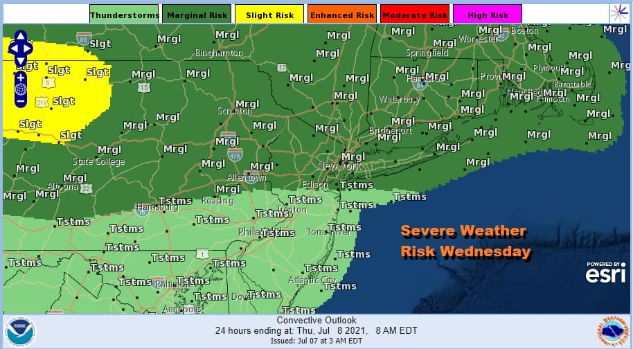
Today we have another round of severe weather risk with another trough approaching but this one has perhaps a little less strength to it. It is going to be another hot and humid day creating instability. The Storm Prediction Center has the southern edge of severe a little further north than yesterday.
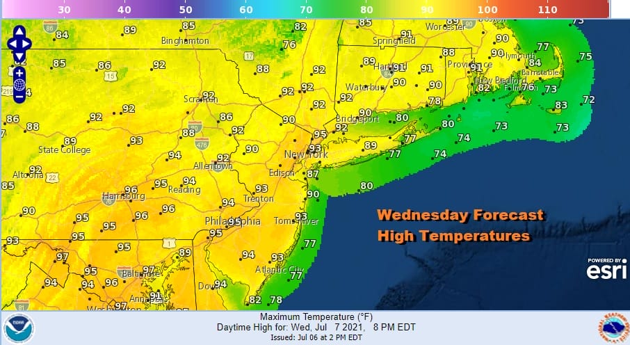
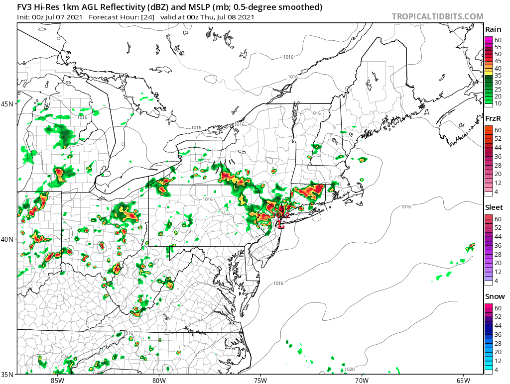
From the standpoint of the satellite views we are wide open for ample daytime heating. Highs will once again reach the low and mid 90s. Dew points will be reaching into the 70s again. Add a cold front and an impulse moving along it and you have the makings for thunderstorms which will develop later this afternoon and evening. The map below is the view for 8pm.
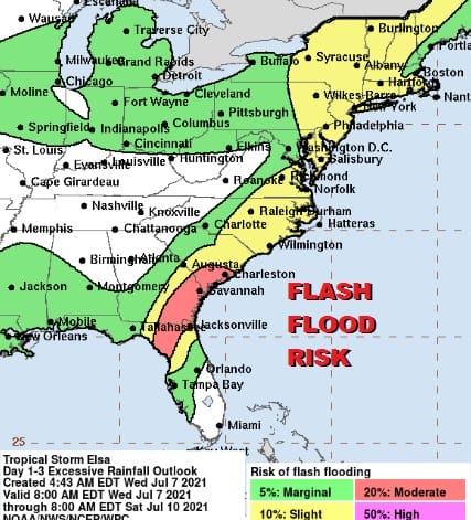
The frontal boundary is going to stall over or just to the west of the immediate coast and it will sit there until something comes along to pull it away to the east. That something is going to be Tropical Storm Elsa which is making landfall in the Florida Coastal Bend today. Elsa is going to turn northeast and track just inland of the Southeast coast of the US and then continue north northeast up the coast Thursday night into Friday morning.
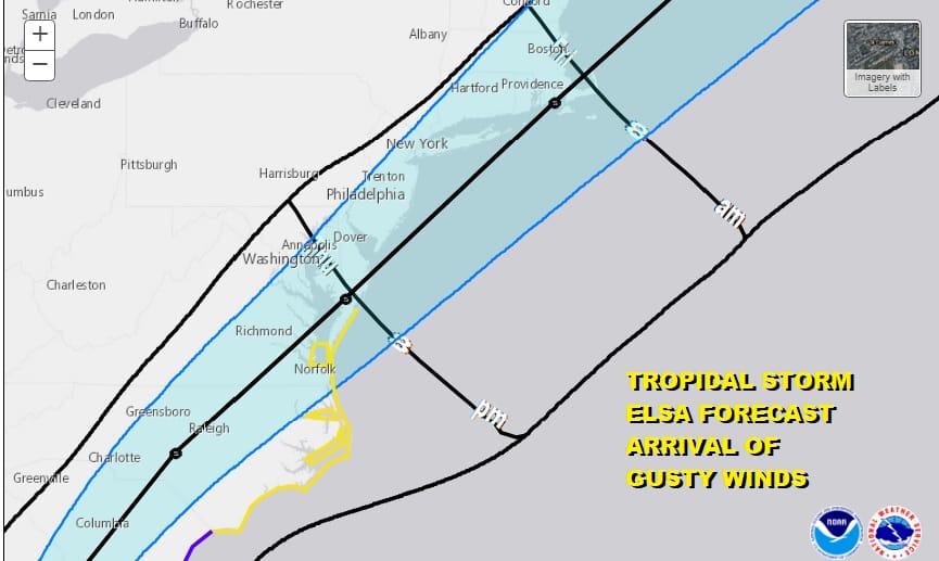
During the day Thursday we will see another very warm humid day. Highs will be in the mid 80s to near 90 degrees. There could be some scattered thunderstorms but much of Thursday should be dry. Then as Elsa moves up the coast we will see rain develop overnight Thursday and then exiting Friday morning as the storm begins to accelerate northeast. Usually as these storms gain latitude they change character. Heavy rain shifts to the west side and the strongest winds will be to the east. With the track offshore, rain would be the biggest issue and we could see up to a couple of inches of rain along the coast with lesser amounts as you head inland. The biggest risk will be localized flash flooding.
This is going to behave like a fast moving noreaster. I don’t believe that wind will be a big issue with fringe gales confined to coastal areas. Weather conditions should start to improve later Friday into Friday night though another shower or thunderstorm can’t be ruled out. The weekend looks to be warm and somewhat humid but mostly dry with just the odd shower or thunderstorm in one or two spots. Highs both days will be in the 80s. We will have more on Elsa later today and tonight on the Joe & Joe Weather Show on Youtube.
BE SURE TO DOWNLOAD THE FREE METEOROLOGIST JOE CIOFFI WEATHER APP &
ANGRY BEN’S FREE WEATHER APP “THE ANGRY WEATHERMAN!

MANY THANKS TO TROPICAL TIDBITS & F5 WEATHER FOR THE USE OF MAPS
Please note that with regards to any severe weather, tropical storms, or hurricanes, should a storm be threatening, please consult your local National Weather Service office or your local government officials about what action you should be taking to protect life and property.


