
Severe Weather Flash Flood Risks Tonight Into Friday
But Weekend Brings Low Humidity & Sunshine

Severe Weather Flash Flood Risks Tonight Into Friday
But Weekend Brings Low Humidity & Sunshine
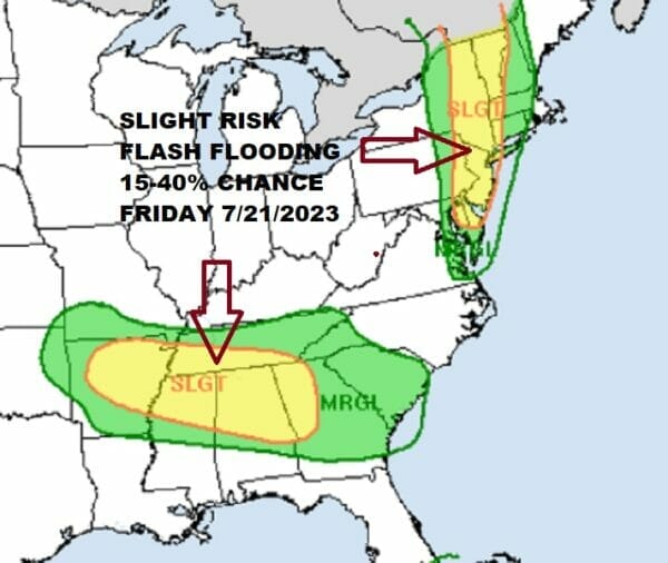
We have one more cold front to get through before we transition over to a low humidity air mass and a nice weekend of summer sunshine and no rain! However we have to get there first and we have another round of downpours, thunderstorms, flash flooding, and severe weather risk to deal with for tonight into Friday. We will start off with the Weather Prediction Center indicating a slight risk (15 to 40% chance) of localized flash flooding for tonight into Friday.
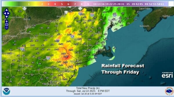
Rainfall amounts will vary but it seems the highest amounts will be in Northern New Jersey and Northeast Pennsylania northward through the Catskills and points north and northeast from there. Forecast amounts are a broad brush outlook. Given the convective nature of summer weather, local amounts could be double the forecast should a thunderstorm sit over one area for a longer stretch of time.
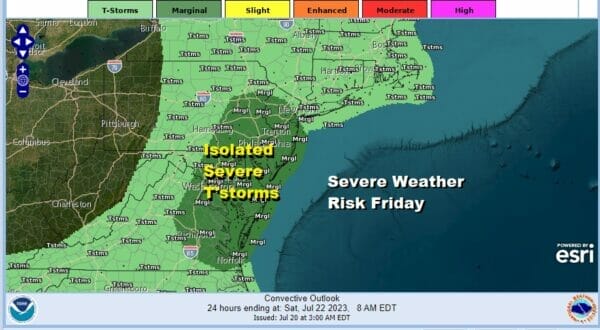
We also have severe weather risk for tonight and Friday per the Storm Prediciction Center. It is a marginal risk for isolated severe thunderstorms overnight and during the day Friday as this cold front passes. The bigger deal here is the rain, as we have seen in most cases this month. There are no issues for today however as most of the area will see sunshine.
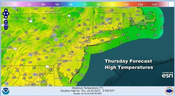
Temperature wise we are looking at high temperatures today in the mid to a few upper 80s. Temperatures should be a little cooler along the shore. We do not expect any thunderstorms to develop during the day or even this evening. Most thunderstorms will occur overnight and probably during the early morning hours of Friday. Humidity levels will be moderate today but headed higher as a warm front approaches. Don’t expect much to show up on satellite and radars today.
SATELLITE WITH LIGHTNING STRIKES

WEATHER RADAR

The good news regarding this system is that it will break the pattern of weather fronts coming through every other day and the frequency of thunderstorm and rain threats should diminish some as we move through the weekend and next. More importantly is the front doesn’t slow down and die near the coast but in fact it keeps its strength and it keeps moving along offshore.

This will allow dry air to move to move into the Eastern US and actually hang on for a few days. The dry air will actually make it unusually far south for this time of year. Dew points in the 50s will cover much of the Eastern and even the Southern US Saturday into Monday of next week!

Showers and thunderstorms tonight will move through and then as the cold front arrives Friday afternoon more showers and thunderstorms will develop. Temperatures Friday will reach into the 80s before the front passes. Storms should exit from west to east during Friday afternoon and improvement will follow.

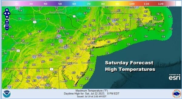
The weekend is looking great with sunshine for Saturday and Sunday. Humidity levels will be low as dew points drop into the 50s. High temperatures will be in the low to mid 80s. It will be quite a change from the oppressive humidity we have experienced on a daily basis since the end of June. Enjoy the lovely weather this weekend as we don’t see air masses like this in July very often.

We should hold on the the low humidity Monday with sunshine and highs in the 80s. After Monday the humidity levels will rise. We may not see much in the way of showers and thunderstorms at least through the first half of next week. This brings a much needed break of unrelenting showers thunderstorms and heavy rain to the Northeast. It is also a chance for river levels to drop off and for the ground to dry up a bit. Tuesday through Thursday looks very warm and humid with sunshine and highs in the mid to upper 80s each day.
BE SURE TO DOWNLOAD THE FREE METEOROLOGIST JOE CIOFFI WEATHER APP &
ANGRY BEN’S FREE WEATHER APP “THE ANGRY WEATHERMAN!
MANY THANKS TO TROPICAL TIDBITS FOR THE USE OF MAPS
Please note that with regards to any severe weather, tropical storms, or hurricanes, should a storm be threatening, please consult your local National Weather Service office or your local government officials about what action you should be taking to protect life and property.
(Amazon is an affilate of Meteorologist Joe Cioffi & earns commissions on sales.)


