Low Humidity & Sunshine Dominates the Weekend
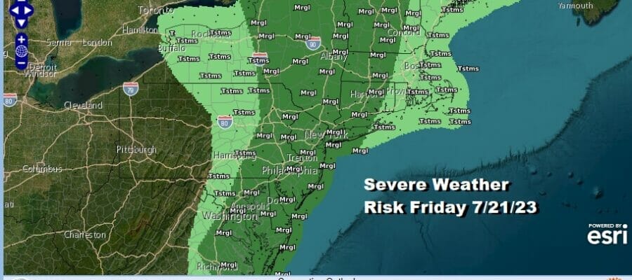
Northeast Mid Atlantic, Severe Weather Risk Today

Low Humidity & Sunshine Dominates the Weekend
Northeast Mid Atlantic, Severe Weather Risk Today

Overnight into this morning we saw a line of severe thunderstorms move through though those storms did weaken some as they reached the coast. Now we look ahead to a cold front that will be coming through late today and ahead of that front we will see one more shot of downpours and thunderstorms later this morning and this afternoon.

The strength of these thunderstorms will depend on how much daytime heating we get but there is the chance we could see some isolated severe thunderstorms later today. There is also the risk for local flash flooding issues. Otherwise look for changeable skies meaning clouds with some sunshine breaking through before any thunderstorms. It will be a humid day with high temperatures in the 80s.
SATELLITE WITH LIGHTNING STRIKES

WEATHER RADAR

The front will move along which is different from all the other cold fronts we have seen this month. This one will not stall out and that is good news. There is a dry air mass moving southeast from Canada and the Great Lakes and that will overspread the Eastern US tonight and over the weekend. Dew points will drop tonight as skies clear. Lows will be in the low to middle 60s with a few 50s in cool spots by Saturday morning.
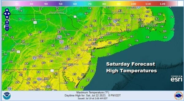
The last 2 weekends, specifically the last 2 Sunday’s have produced soaking rains and flash flooding. This weekend will be totally different. A deep upper trough in the Eastern US spreads dry air as far south as the Northern Gulf States and the interior Southeast US. We will have a rare weekend of sunshine for both Saturday and Sunday.
Dew point temperatures (the temperature at which dew forms) which are used with air temperatures to calculate relative humidity will be in the 50s. The wide spread between the dew point and the temperature will mean low relative humidity right through the weekend. Saturday will be a day of plenty of sunshine and the same holds for Sunday. High temperatures will be in the low to mid 80s both days making this the best weekend of the summer season so far.

Next week will be a warm through Wednesday and then it may turn hot late next week. The pattern of weather fronts coming through every 2 days or so continues into Wednesday so we will throw in the chance for a scattered thunderstorm late Monday and again late Tuesday. Both days should feature sunshine for much of the day with highs in the mid to upper 80s. It will start to slowly turn a little more humid through midweek. Late next week with a west southwest flow, look for humidity levels to come up markedly and temperatures in the Northeast and Middle Atlantic states will be in the hot side with at least a couple of days with highs reaching 90 or better. Have a great weekend and enjoy the break from summer humidity.
BE SURE TO DOWNLOAD THE FREE METEOROLOGIST JOE CIOFFI WEATHER APP &
ANGRY BEN’S FREE WEATHER APP “THE ANGRY WEATHERMAN!
MANY THANKS TO TROPICAL TIDBITS FOR THE USE OF MAPS
Please note that with regards to any severe weather, tropical storms, or hurricanes, should a storm be threatening, please consult your local National Weather Service office or your local government officials about what action you should be taking to protect life and property.
(Amazon is an affilate of Meteorologist Joe Cioffi & earns commissions on sales.)


