Severe Weather Risks Next 3 Days
Weekend Brings Low Humidity & Rain Free Conditions

Severe Weather Risks Next 3 Days
Weekend Brings Low Humidity & Rain Free Conditions
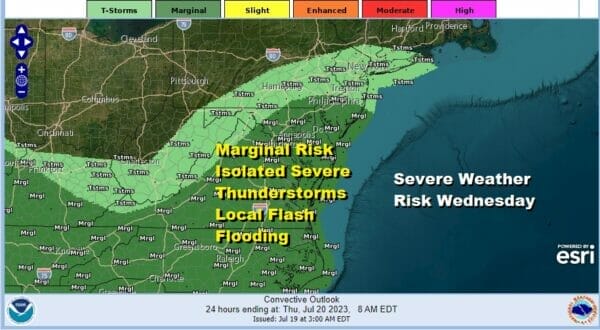
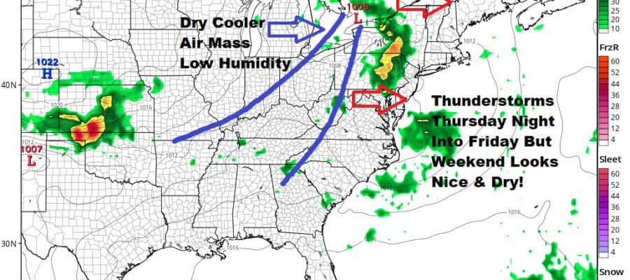
We seem to be moving along in the right direction as the risk for thunderstorms will be with us into Friday however today’s risk cuts off across Central New Jersey and Southeast Pennsylvania. North of NYC and into New England the chances for thunderstorms today drops off and that’s good news. Mariginal risk is being indicated by the Storm Prediction Center from South Jersey and Southeast Pennsylvania and points south into the Carolains and west into the Lower Ohio Valley. Isolated severe thunderstorms are possible and storms could create localized flash flood issues.
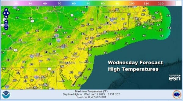
We could see a little break in the dew points later today even though the break is a small and shallow one. We also have an upper trough producing thunderstorms and they show up on the satellite and radar loops. In between any shower or thunderstorm activity, we should see clouds and some sunshine with highs in the low to mid 80s. North of NY up the Hudson Valley and into New England you will probably see more in the way of sunshine today and little risk for a storm.
SATELLITE WITH LIGHTNING STRIKES

WEATHER RADAR

Thursday and Friday we see yet another cold front approaching from the west. The trick with this weather front will be to get it through and to keep it moving so that we can take part in some nice real dry air over the weekend with 2 days of sunshine and no showers or thunderstorms to worry about.

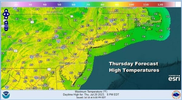
Much of Thursday dayside looks to be dry with sunshine. The humidity will be coming up a bit but the dew points should stay under 70 which is uncomfortable but not extreme. Thunderstorms will develop ahead of the cold front but the timing seems to indicate that thunderstorms will move across Pennsylvania and New Jersey and then into Southern New England overnight Thursday into Friday morning. Highs Thursday will be in the mid to upper 80s.
We will have an upper trough moving through Friday and that could set off some thunderstorms Friday morning into the afternoon before we see the frontal boundary move offshore. Perhaps some sun returns late in the day Friday. Highs will be in the mid to upper 80s. There is severe weather risk being indicated for Thursday night and Friday. For now it is a marginal risk but we could see this expand a bit.

We have seen a number of fronts approach our area this month but none of them were able to move through. Shots of cool dry air have remained in the Plains and Upper Midwest where temperatures have been below average all month long. This front is different and as a deep upper trough moves into the Eastern US over the weekend, it looks to bring dry air all the way to the Deep South as well as much of the East Coast.

This loop above shows the dew points and notice the green area which represents dew points under 60 degrees. This is very nice dry air and that dry air comes into the Eastern and Southern US this weekend. It actually hangs around through the weekend. More importantly is thunderstorm activity which takes a break from the forecast through the weekend and even for the first couple of days of next week!
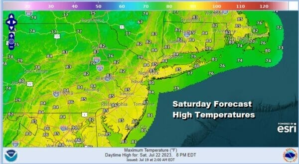

This leaves us with a weekend of sunshine, low humidity, and hopefully smoke free conditions. It would be a waste of all this dry air if it comes with a smokey haze. We will deal with those issues Thursday and Friday if it is indeed an issue. Highs both days will be in the low to mid 80s and nights will be in the 60s to low 70s under a clear sky. No showers or thunderstorms are in the forecast for the first weekend in 3. Take advantage while it lasts because the humidity will eventually return when the upper trough pulls out of the Eastern US next week.
BE SURE TO DOWNLOAD THE FREE METEOROLOGIST JOE CIOFFI WEATHER APP &
ANGRY BEN’S FREE WEATHER APP “THE ANGRY WEATHERMAN!
MANY THANKS TO TROPICAL TIDBITS FOR THE USE OF MAPS
Please note that with regards to any severe weather, tropical storms, or hurricanes, should a storm be threatening, please consult your local National Weather Service office or your local government officials about what action you should be taking to protect life and property.
(Amazon is an affilate of Meteorologist Joe Cioffi & earns commissions on sales.)


