Severe Weather Ends Weather Conditions Improve Tuesday
Severe Weather Ends Weather Conditions Improve Tuesday
All weather watches and warnings are discontinued across the region. The severe weather from late this afternoon and this evening is now done. There are some residual downpours still to work through in some places as evidenced by the latest radar loops. However weather conditions will improve during the early morning hours and this should set us up for a nice Tuesday of sunshine, lower humidity and temperatures in the 80s…though of course cooler at the shore.
SATELLITE LOOP

REGIONAL RADAR

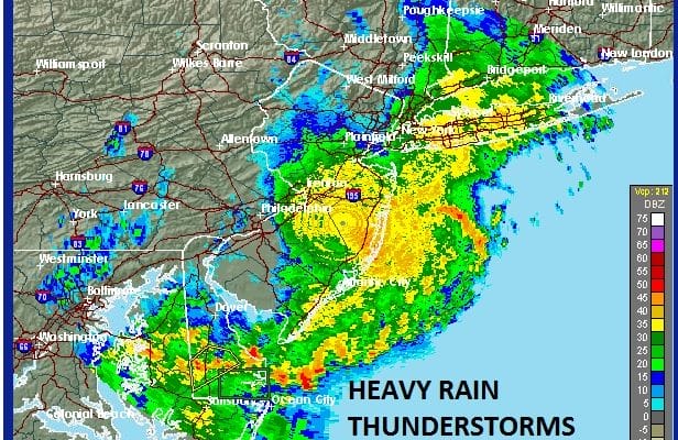
LOCAL RADAR NEW YORK CITY

LOCAL RADAR PHILADELPHIA


You can see the rains on the local radar moving to the east and the western edge is reaching the coast in short order. With Tuesday looking good, Wednesday looks ok though there is an upper air disturbance that will be working through which will produce clouds and perhaps a passing shower or thunderstorm in one or two spots. For most though Wednesday will be rain free. Thursday looks good with sunshine and a few clouds with highs in the upper 70s and lower 80s. The next chance for showers will arrive later on Friday and possibly linger into Saturday as another cold front approaches. It doesn’t appear that we have another severe weather event of magnitude to worry about for this week. Also with the jet stream remaining fairly active, weather fronts will be pushing through every couple of days. This will prevent any heatwaves from developing in the near future.
Tropical Depression 3 in the Central Gulf of Mexico is close to becoming a tropical storm. JOESTRADAMUS has more on this along with the latest hurricane model forecasts and analysis.
 GET JOE A CIGAR IF YOU LIKE


