Severe Thunderstorms Popping Brutally Hot Humid
Severe Thunderstorms Popping Brutally Hot Humid
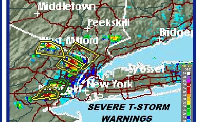
The steam bath air mass is entrenched in our area and we are seeing some pop up severe thunderstorms that have developed in areas surrounding NYC. You can see the blow up on the visible satellite loop below. Several severe thunderstorm warnings have already been issued for parts of Northern New Jersey so far and others are likely to develop as we go into the late afternoon and evening.
EASTERN SATELLITE

REGIONAL RADAR

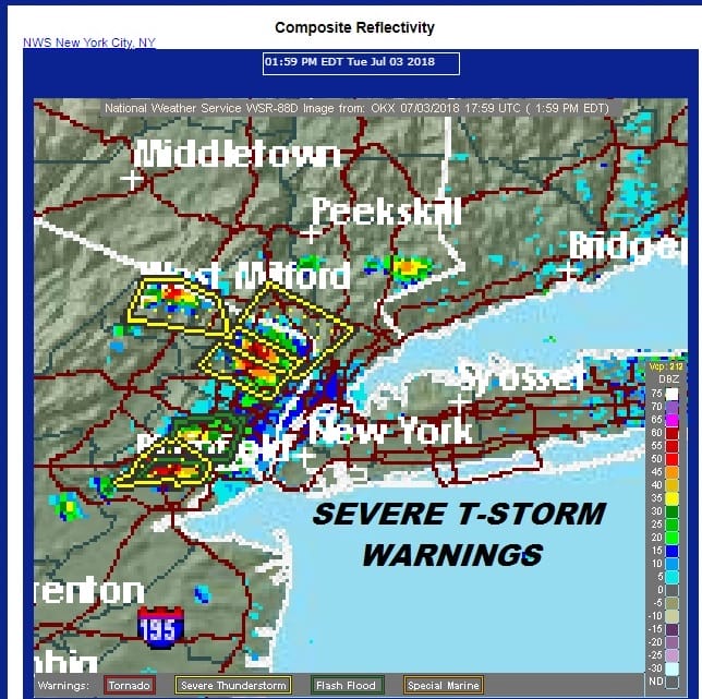
..A SEVERE THUNDERSTORM WARNING REMAINS IN EFFECT UNTIL 300 PM EDT
FOR NORTHEASTERN BERGEN...SOUTHERN WESTCHESTER AND ROCKLAND
COUNTIES...

At 235 PM EDT, a severe thunderstorm was located over Tappan, moving
northeast at 10 mph.

HAZARD...60 mph wind gusts.

SOURCE...Radar indicated.

IMPACT...Expect damage to trees and power lines.

This severe storm will be near...
  Tappan around 240 PM EDT.
  Pearl River around 245 PM EDT.
  Nanuet and Dobbs Ferry around 255 PM EDT.
  Nyack around 300 PM EDT.

PRECAUTIONARY/PREPAREDNESS ACTIONS...

For your protection move to an interior room on the lowest floor of a
building.

Torrential rainfall is occurring with this storm, and may lead to
flash flooding. Do not drive your vehicle through flooded roadways.
LOCAL RADAR NEW YORK CITY

LOCAL RADAR PHILADELPHIA


...A SEVERE THUNDERSTORM WARNING REMAINS IN EFFECT UNTIL 300 PM EDT
FOR NORTHEASTERN BERGEN...SOUTHERN WESTCHESTER AND ROCKLAND
COUNTIES...

At 235 PM EDT, a severe thunderstorm was located over Tappan, moving
northeast at 10 mph.

HAZARD...60 mph wind gusts.

SOURCE...Radar indicated.

IMPACT...Expect damage to trees and power lines.

This severe storm will be near...
  Tappan around 240 PM EDT.
  Pearl River around 245 PM EDT.
  Nanuet and Dobbs Ferry around 255 PM EDT.
  Nyack around 300 PM EDT.

PRECAUTIONARY/PREPAREDNESS ACTIONS...

For your protection move to an interior room on the lowest floor of a
building.

Torrential rainfall is occurring with this storm, and may lead to
flash flooding. Do not drive your vehicle through flooded roadways.
 GET JOE A CIGAR IF YOU LIKE

LATEST JOESTRADAMUS ON THE LONG RANGE