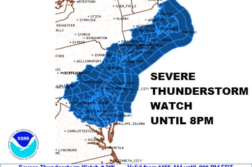
Severe Thunderstorm Watch Until 8pm Thunderstorms Developing Risks Wind Hail

Weather in 5/Joe & Joe Weather Show Latest Podcast
Severe Thunderstorm Watch Until 8pm Thunderstorms Developing Risks Wind Hail
The NWS Storm Prediction Center has issued a
* Severe Thunderstorm Watch for portions of
Connecticut
District Of Columbia
Delaware
Southeast Massachusetts
Central and Eastern Maryland
New Jersey
Southeast New York
Southeast Pennsylvania
Rhode Island
Northeast Virginia
Coastal Waters
* Effective this Wednesday morning and evening from 1155 AM until
800 PM EDT.
* Primary threats include…
Scattered damaging wind gusts to 70 mph likely
Scattered large hail events to 1.5 inches in diameter possible
SUMMARY…Scattered strong to severe thunderstorms will develop this
afternoon along a weak cold front extending from northern Virginia
into eastern Massachusetts. The strongest cells will pose a risk of
damaging wind gusts and hail.
Daytime heating is underway and thunderstorms are beginning to develop across Pennsylvania. There is a renegade area that has formed on the radars in New Jersey and that is running ahead of what will be the main line of storms for this afternoon. The Storm Prediction Center has put up a Severe Thunderstorm Watch until 8pm from Northeast Virginia to Southeast New England. This includes all the major cities from Washington to Baltimore, Philadelphia, NYC, Hartford, Providence, and Boston.
SATELLITE

WEATHER RADAR


SEVERE THUNDERSTORM WATCH COUNTIES

CONNECTICUT COUNTIES INCLUDED ARE
FAIRFIELD HARTFORD MIDDLESEX
NEW HAVEN NEW LONDON TOLLAND
WINDHAM
NEW JERSEY COUNTIES INCLUDED ARE
ATLANTIC BERGEN BURLINGTON
CAMDEN CAPE MAY CUMBERLAND
ESSEX GLOUCESTER HUDSON
HUNTERDON MERCER MIDDLESEX
MONMOUTH MORRIS OCEAN
PASSAIC SALEM SOMERSET
SUSSEX UNION WARREN
NEW YORK COUNTIES INCLUDED ARE
BRONX KINGS NASSAU
NEW YORK ORANGE PUTNAM
QUEENS RICHMOND ROCKLAND
SUFFOLK WESTCHESTER
PENNSYLVANIA COUNTIES INCLUDED ARE
ADAMS BERKS BUCKS
CHESTER CUMBERLAND DAUPHIN
DELAWARE FRANKLIN LANCASTER
LEBANON LEHIGH MONTGOMERY
NORTHAMPTON PHILADELPHIA SCHUYLKILL
YORK
RHODE ISLAND COUNTIES INCLUDED ARE
BRISTOL KENT NEWPORT
PROVIDENCE WASHINGTON
DC
DISTRICT OF COLUMBIA COUNTIES INCLUDED ARE
DISTRICT OF COLUMBIA
DELAWARE COUNTIES INCLUDED ARE
KENT NEW CASTLE SUSSEX
MARYLAND COUNTIES INCLUDED ARE
ANNE ARUNDEL BALTIMORE CALVERT
CAROLINE CARROLL CECIL
CHARLES DORCHESTER FREDERICK
HARFORD HOWARD KENT
MONTGOMERY PRINCE GEORGES QUEEN ANNE’S
SOMERSET ST. MARYS TALBOT
WASHINGTON WICOMICO WORCESTER
MARYLAND INDEPENDENT CITIES INCLUDED ARE
BALTIMORE CITY
BE SURE TO DOWNLOAD THE FREE METEOROLOGIST JOE CIOFFI WEATHER APP &
ANGRY BEN’S FREE WEATHER APP “THE ANGRY WEATHERMAN!

MANY THANKS TO TROPICAL TIDBITS & F5 WEATHER FOR THE USE OF MAPS
Please note that with regards to any severe weather, tropical storms, or hurricanes, should a storm be threatening, please consult your local National Weather Service office or your local government officials about what action you should be taking to protect life and property.