
Severe Thunderstorm Watch NE Pennsylvania Heat Advisory Heat Warnings
Severe Thunderstorm Watch NE Pennsylvania
Heat Advisory Heat Warnings
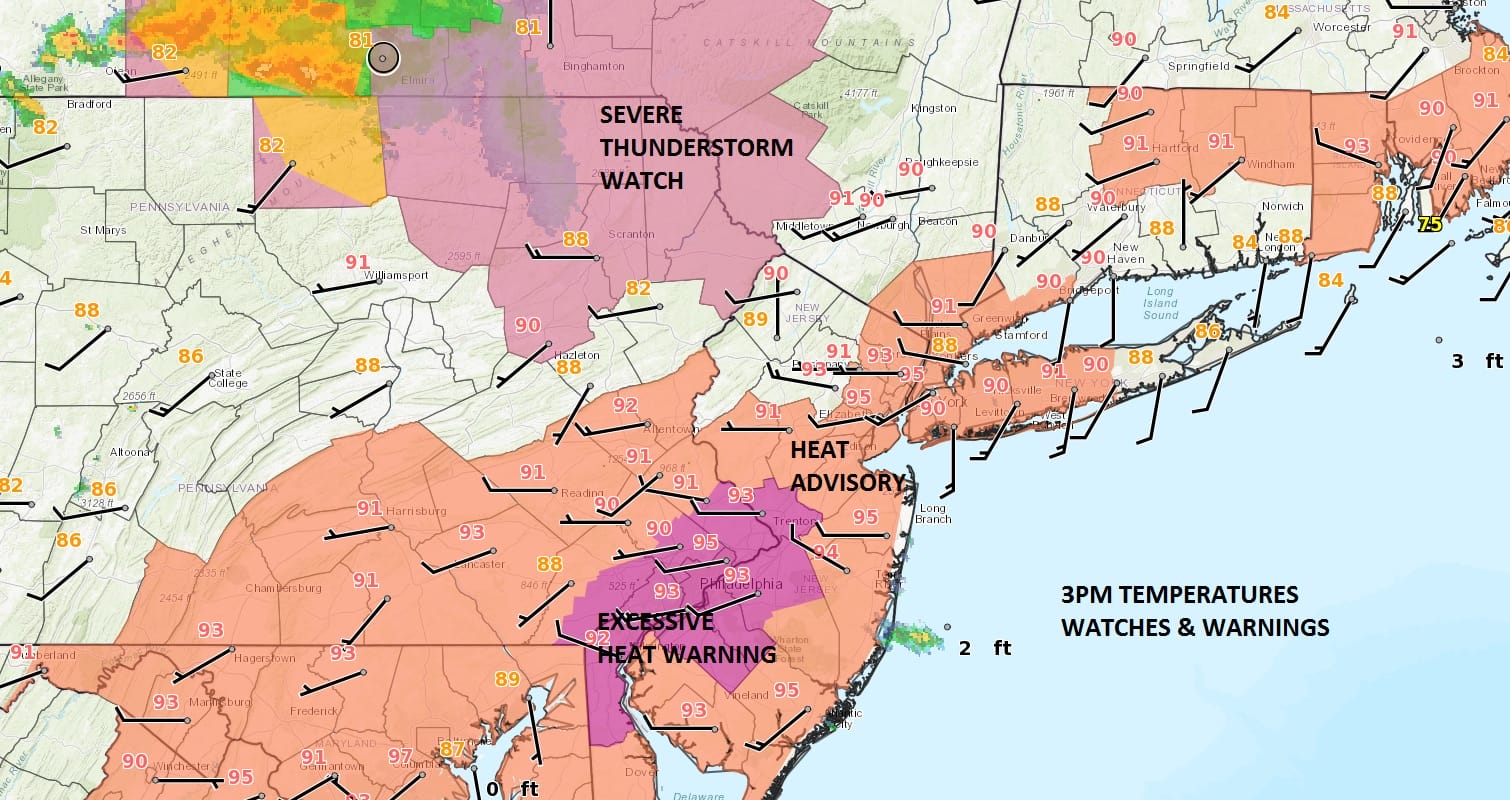
Weather conditions at 3pm are obvious. It is a blast furnace everywhere with temperatures in the low to mid 90s. Various heat advisory, excessive heat, and don’t breathe alerts are up into this evening. We also have a Severe Thunderstorm Watch posted for the northeastern Counties of Pennsylvania and the Western Catskills. Though the thunderstorms that are developing will hold together to some degree as they move east this evening, I’m not anticipating the severe thunderstorm watch to be extended eastward. However there could be some strong surviving cells in the mix as that area heads toward the coast later this evening. It appears to me that the the thunderstorm threat time will be from 7pm to midnight from Northwest New Jersey to Long Island. The Storm Prediction Center has this area at a marginal risk of severe weather with a slight risk possible in Northwest New Jersey.
SATELLITE LOOP

REGIONAL RADAR

LOCAL RADAR NEW YORK CITY

LOCAL RADAR PHILADELPHIA


Nothing is close on the radar at the moment so we may get through the evening rush hour commute without any issues. Once these storms play through it will be a warm and humid night with most lows in the upper 60s to mid 70s. Friday we see sunshine developing and it should be mostly sunny from mid morning on. It will be another hot day with highs in the 90s but the humidity should drop somewhat in the afternoon and evening.
HRRR MODEL SEVERE THUNDERSTORMS FROM 4PM-10PM THURSDAY
CLICK TO ANIMATE

Saturday starts with plenty of sun but a warm front comes back and thunderstorms are possible by evening. Saturday will start reasonable and finish more humid. Sunday looks hot and humid with the risk for thunderstorms as the next cold front begins its approach. Thunderstorms heat and humidity are likely Monday but real relief should arrive Tuesday and Wednesday with temperatures in the lower 80s and much lower humidity.
 GET JOE A CIGAR IF YOU LIKE

LANDSCAPE COMPANIES FOR YOUR NEEDS
LONG ISLAND ROCKLAND COUNTY Connecticut

![]()

ROCKLAND COUNTY TRI STATE SNOW REMOVAL JOHNSTOWN PA


FiOS1 News Weather Forecast For Long Island
FiOS1 News Weather Forecast For New Jersey
FiOS1 News Weather Forecast For Hudson Valley
NATIONAL WEATHER SERVICE SNOW FORECASTS
LATEST JOESTRADAMUS ON THE LONG RANGE
Weather App

Don’t be without Meteorologist Joe Cioffi’s weather app. It is really a meteorologist app because you get my forecasts and my analysis and not some automated computer generated forecast based on the GFS model. This is why your app forecast changes every 6 hours. It is model driven with no human input at all. It gives you an icon, a temperature and no insight whatsoever.
It is a complete weather app to suit your forecast needs. All the weather information you need is right on your phone. Android or I-phone, use it to keep track of all the latest weather information and forecasts. This weather app is also free of advertising so you don’t have to worry about security issues with your device. An accurate forecast and no worries that your device is being compromised.
Use it in conjunction with my website and my facebook and twitter and you have complete weather coverage of all the latest weather and the long range outlook. The website has been redone and upgraded. Its easy to use and everything is archived so you can see how well Joe does or doesn’t do when it comes to forecasts and outlooks.
Just click on the google play button or the apple store button on the sidebar for my app which is on My Weather Concierge. Download the app for free. Subscribe to my forecasts on an ad free environment for just 99 cents a month.
Get my forecasts in the palm of your hand for less than the cost of a cup of Joe!


