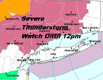
Severe Thunderstorm Watch Hudson Valley Northeast PA, Parts of Northern New Jersey
We thought this evening would be uneventful for the most part with just a few scattered thunderstorms but the line of thunderstorms in upstate NY has held up rather well and that has prompted a Severe Thunderstorm Watch to be posted for Northeast Pennsylvania, the Catskills, The Hudson Valley, Northern and Northwest New Jersey.
SATELLITE

NEW JERSEY COUNTIES INCLUDED ARE
BERGEN PASSAIC SUSSEX
WARREN
NEW YORK COUNTIES INCLUDED ARE
ORANGE PUTNAM ROCKLAND
WESTCHESTER
CONNECTICUT COUNTIES INCLUDED ARE
FAIRFIELD HARTFORD LITCHFIELD
MIDDLESEX NEW HAVEN TOLLAND
IN CENTRAL NEW YORK
DELAWARE SULLIVAN
IN PENNSYLVANIA THIS WATCH INCLUDES 7 COUNTIES
IN NORTHEAST PENNSYLVANIA
BRADFORD LACKAWANNA LUZERNE
PIKE SUSQUEHANNA WAYNE
WYOMING
REGIONAL RADAR

We can see that the southern end of this line of thunderstorms moving rapidly eastward. The main threat from these storms will be strong gusty winds of 60 mph or more and hail. These storms are the result of an approaching cold front and once again the daytime heating was stronger today with sunshine and dew points that hung stubbornly close to 70. The threat time will be from now until midnight.
LOCAL RADAR NEW YORK CITY

LOCAL RADAR PHILADELPHIA 

There are no other changes in the outlook going forward through the weekend. Once these storms end skies will clear out tonight and humidity levels will drop quickly on Friday. Dry nice weather is with us for the weekend and this will likely be the best weekend weatherwise of the summer so far. More cold fronts and more changes coming next week.
MANY THANKS TO TROPICAL TIDBITS FOR THE USE OF MAPS
Please note that with regards to any tropical storms or hurricanes, should a storm be threatening, please consult your local National Weather Service office or your local government officials about what action you should be taking to protect life and property.