
Severe Thunderstorm Watch Continues through 10pm
Severe Thunderstorm Watch Continues through 10pm

We have already seen a couple of severe thunderstorms move through parts of New Jersey and the Hudson Valley. These are basically renegade severe thunderstorm cells that formed well ahead of the main line of storms that will come later this evening. This is all ahead of a weather front that will move through and bring a gradual lowering of the oppressive humidity over the weekend. First things first however is this evening when the main line of storms that is forming inside the red box above moves to the east. These storms will swing across Eastern Pennsylvania and head to Western New England and Long Island. It is hard to say where the strongest thunderstorms will be so it is best to remember that the Severe thunderstorm watch covers a rather large geographic are. The risk is there even if it turns out you are spared severe weather.
SEVERE THUNDERSTORM WATCH UNTIL 10PM
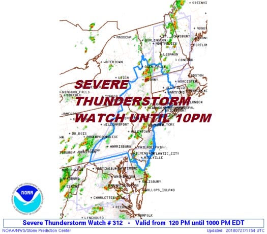
The very unstable air mass we are in and the approaching energy and front to the west are creating lots of “lift” allowing for thunderstorms to develop. The satellite loop shows the lead storms forming and moving east and the stronger second area taking shape to the west.
EASTERN SATELLITE

REGIONAL RADAR

LOCAL RADAR NEW YORK CITY

LOCAL RADAR PHILADELPHIA


Once all this gets out of here tonight we are looking ahead to a better weekend. Dry air will begin to ease in Saturday but it will come in slowly. It will still be somewhat humid but it will be lower than today and we will see a mix of sun and clouds Saturday. Highs will be in the 80s and we are leaving thunderstorms out of the forecast for the entire weekend.Sunday should be a nice day with sunshine and lower humidity with highs again in the 80s. Sunday looks like a very nice day. Monday looks rain free though the humidity starts to increase. It appears that there will be an increasing chance for afternoon and evening scattered thunderstorms later next week. along with very warm and humid conditions.
Please note that with regards to any tropical storms or hurricanes, should a storm be threatening, please consult your local National Weather Service office or your local government officials about what action you should be taking to protect life and property.
 GET JOE A CIGAR IF YOU LIKE

LATEST JOESTRADAMUS ON THE LONG RANGE


