Severe Thunderstorm Threat Flash Flood Watch New Jersey Pennsylvania
Severe Thunderstorm Threat Flash Flood Watch New Jersey Pennsylvania Southward

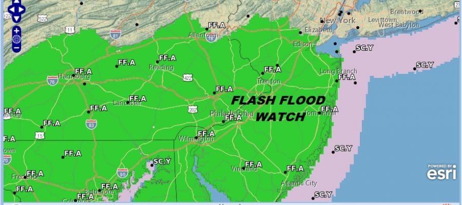
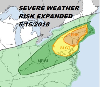
We have Flash Flood Watches posted for this evening across much of New Jersey and Eastern Pennsylvania mainly along and south of Route 78. This coincides with the severe weather threat that looms this afternoon. As of the 7am forecast we have an enhanced risk for severe from Northeastern Pennsylvania & Northwest New Jersey northeastward to the Hudson Valley and Connecticut along and north of Route 84. A large area of slight risk for severe weather extends to just west of Boston all the way south to NYC, Philadelphia, and Washington DC.
SEVERE WEATHER THREAT TUESDAY 5/15/2018
Nothing of consequence should happen until very late this afternoon and this evening. A buckling frontal boundary will combine with strong upper air dynamics and a warm sector that should make it this time into New England to produce severe weather. The satellite picture this morning is rather tame with just some patchy clouds around. Before too long the daytime heating gets underway and temperatures will be heading into the 80s.
US SATELLITE

REGIONAL RADAR

Regional radars aren’t showing anything nearby as showers for now are well to the north and west and are beginning to spread into upstate NY. Local area radars should be quiet until mid afternoon.
LOCAL RADAR NEW YORK CITY

LOCAL RADAR PHILADELPHIA


Weather models all see to line up closely for thunderstorms to move through between 4pm and 7pm and it seems that they all hold the line up as they move toward coastal areas. For south facing coastlines wind direction will be key as the south wind will likely weaken any storms as they approach.
HRRR MODEL 5PM TUESDAY MAY 15, 2018

Weather conditions should improve somewhat overnight but over the next several days we will be dealing lots of clouds and the possibility of some on and off showers. Late this week we will be watching disturbed weather that has been over the Eastern Gulf of Mexico producing rains in Florida and the Southeast US. This moisture is destined to come up the east coast bring some rain here late this week and the threat for rain continues over the weekend.
 GET JOE A CIGAR IF YOU LIKE

FiOS1 News Weather Forecast For Long Island
FiOS1 News Weather Forecast For New Jersey
FiOS1 News Weather Forecast For Hudson Valley


