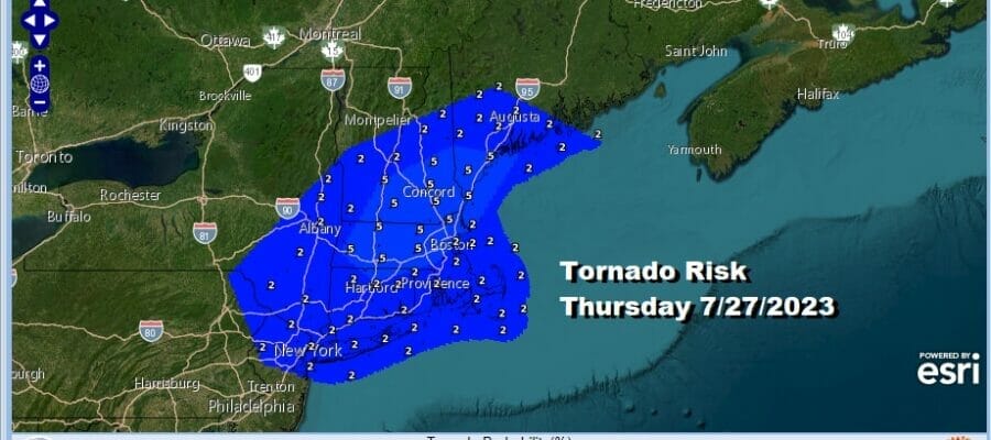

Severe Thunderstorm & Elevated Tornado Risk Thursday
Heatwave 90s Next 4 Days

We are setting up for what could be a significant severe weather event for the Northeast Thursday. An upper trough will be moving eastward from the Great Lakes late today to the Northeast. This is going to set off the risk for severe thunderstorms but we do see elevated tornado risk for later Thursday into Friday in the range of 2 to as much as a 5 percent chance of a tornado within 25 miles of any point in the blue area on the map above.

The area of severe weather risk is extensive and covers the area from Northeast Virginia northeastward into Maine. This area is in a slight risk for severe weather which is a 15 percent chance with a marginal risk (5%) chance) extending further north into Maine and south to the North Carolina state line. I would not be at all surprised if we wind up seeing an enhanced risk zone being added to this come Thursday morning.

Today begins what I woucl define as a mini heatwave in much of the Eastern US. Highs will reach into the 90s this afternoon especially away from the coast. We had severe weather move through parts of Eastern Pennsylvania to Southern New England yesterday. Today looks to be a completely thunderstorm free day as high pressure settles along the coast. Sunshine will be around much if not all of the day. Humidity levels will be shooting up as dew points head over 70 so expect uncomfortable conditions.
SATELLITE WITH LIGHTNING STRIKES

WEATHER RADAR

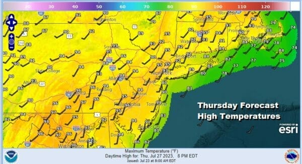
Thursday we will go from hot to very hot as sunshine will take highs into the low and middle 90s. Combine this with dew points in the 70s and you have a recipe for a very unstable atmosphere. Now let us throw in a ripple in the jet strean bringing a shortwave trough across the Great Lakes and Northeast late Thursday and Thursday night. This will set off thunderstorms in the late afternoon and evening and the atmospheric dynamics justify the elevated risk indicated by the Storm Prediction Center.
Friday will set up to be the hottest day of this stretch thanks to winds that will be more west southwest or even westerly. This keeps the cooler ocean out of the way and allows land temperatures and even coastal temperatures to heat up. Sunshine Friday will take highs to the middle and upper 90s for highs. Humidity once again will be awful with dew points into the 70s.

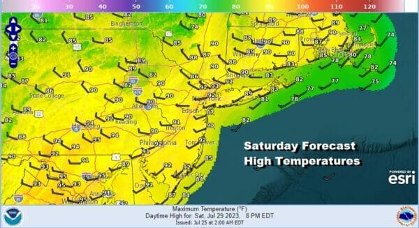
There are some model differences regarding whether we will see thunderstorms late Friday into Friday night. A weak upper trough will move through. Due to the extent of the daytime heating I will mention the chance for a scattered shower or thunderstorm popping up but for most it would seem Friday will be storm free. This will likely not be the case Saturday as a cold front arrives. Ahead of it we will have one last day of heat and humidity with highs into the 90s.
We do see the possibility of thunderstorms as well as the potential for severe weather in the Northeast and Northern Mid Atlantic when the front passes late in the day. Behind the front however we will see a nice dry air mass build southeastward from Canada bringing sunshine and lower humidity back Sunday.
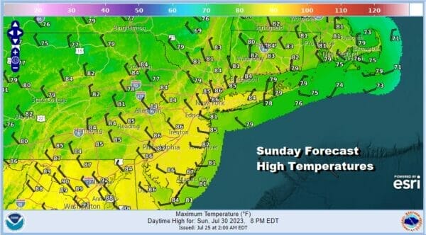
The core of the cool air mass will build in Sunday night and Monday in the Northeast. This should takes temperatures down into the 50s and 60s Sunday night. Monday will be a rather pleasant day with sunshine and highs will be in the upper 70s and lower 80s! This is definitely something to look forward to.
BE SURE TO DOWNLOAD THE FREE METEOROLOGIST JOE CIOFFI WEATHER APP &
ANGRY BEN’S FREE WEATHER APP “THE ANGRY WEATHERMAN!
MANY THANKS TO TROPICAL TIDBITS FOR THE USE OF MAPS
Please note that with regards to any severe weather, tropical storms, or hurricanes, should a storm be threatening, please consult your local National Weather Service office or your local government officials about what action you should be taking to protect life and property.
(Amazon is an affilate of Meteorologist Joe Cioffi & earns commissions on sales.)


