Severe Weather Elevated Tornado Risk Heat & Humidity All On the Table Today

Severe Weather Elevated Tornado Risk Heat & Humidity All On the Table Today

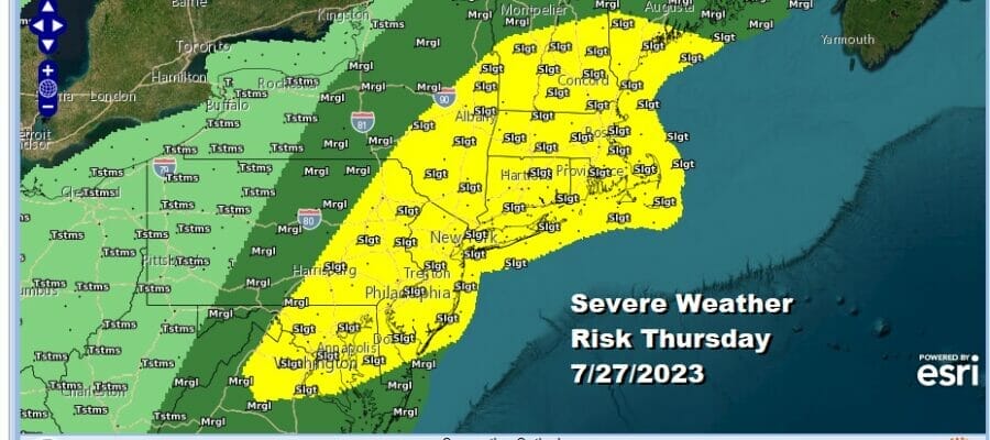
This is going to be one of those hot humid days where you just want to be in a pool, beach, or in air conditioning. The Northeast and Northern Mid Atlantic have not seen many 90 degree plus highs this summer. Today and tomorrow for many areas could wind up being the hottest temperatures of the summer as highs reach the low and middle 90s this afternoon. We also have an upper trough that is moving along from the Great Lakes and Northeast late today and tonight. This puts us in the risk zone for severe weather and the Storm Prediction Center continues to indicate a slight risk from Northeast Virginia to Maine and everyone in between.

Tornado risk is elevated in the Northeast with 2 to 5 percent risk values being indicated. These are numbers we don’t see very often. On the satellite loop you can see the rotation over the Eastern Great Lakes and this could create conditions for a few tornadoes to spin up with the highest risk in New England but the risk does extend southward to Northern New Jersey.
SATELLITE WITH LIGHTNING STRIKES

WEATHER RADAR

The highest risk time for thunderstorms will be from 3pm to 10pm across the area. It is hard to say exactly who sees what and when but based on short range models, there should be one solid line of storms that develops and moves east from Eastern Pennsylvania to Southern New England but we will rely on radars this afternoon to determine the scope of the thunderstorm activity.

We are in this pattern where these upper troughs/cold fronts move through every other day so that means we will skip Friday and that leaves us with a very hot very humid day. Friday we will see mostly west winds and that is usually the wind direction that brings some of the hottest temperatures to the Northeast and Northern Mid Atlantic states.

That could make Friday the hottest day of the summer season with highs reaching the middle to upper 90s. Even the shore will see highs reach 90 degrees as the sea breeze will have to fight its way inland. Thunderstorms could pop up in scattered places in the afternoon and evening but they should be few and far between.

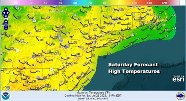
Saturday will be the last hot and humid day as we have a cold front that will be approaching from the Northwest Temperatures Saturday with sunshine will reach into the 90s but we will likely see thunderstorms in the afternoon and evening as the front moves through. We also have severe weather risk indicated for Saturday by the Storm Prediction Center.
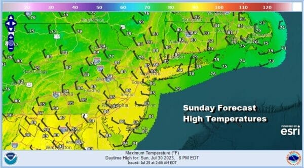
This front is going mark the leading edge of lower humidity and cooler temperatures that will start to build in Sunday and will likely be with us through much of next week. Sunday look for clouds and sunshine. There is the risk for a pop up shower or thunderstorm. Most highs will be in the upper 70s to a few middle 90s. More importantly the dew points will be heading for the upper 50s and lower 60s making things more comfortable.
Next week the weather is going do be downright delightful at least through Wednesday and probably through Thursday. Humdiity levels will be very low as dew points head for the 40s! Highs wll be in the upper 70s and lower 80s on most days and there should be a fair amount of sunshine. It is a wonderful finish to July and and a rather lovely start to the month of August.
BE SURE TO DOWNLOAD THE FREE METEOROLOGIST JOE CIOFFI WEATHER APP &
ANGRY BEN’S FREE WEATHER APP “THE ANGRY WEATHERMAN!
MANY THANKS TO TROPICAL TIDBITS FOR THE USE OF MAPS
Please note that with regards to any severe weather, tropical storms, or hurricanes, should a storm be threatening, please consult your local National Weather Service office or your local government officials about what action you should be taking to protect life and property.
(Amazon is an affilate of Meteorologist Joe Cioffi & earns commissions on sales.)


