Scattered Shower or Thunderstorm Late Today
Dry Conditions Thursday Lasting Possibly Through Sunday

Scattered Shower or Thunderstorm Late Today
Dry Conditions Thursday Lasting Possibly Through Sunday

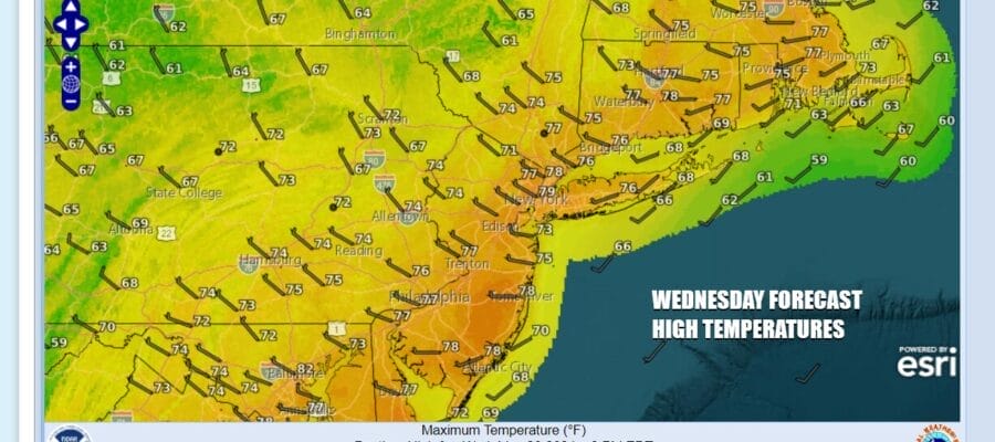
We have a second upper trough that will be moving through the Northeast and Northern Mid Atlantic states so we will need to put in the chance for scattered showers and thunderstorms this afternoon and evening. However it is another case where showers and storms will be scattered in nature and not everyone will see them. Rainfall amounts from the showers will likely be minimal. Otherwise it is day that starts with sunshine but then we see developing clouds. Showers play through in the afternoon and evening and then weather conditions improve overnight as skies partially clear. Most highs today will be in the mid 70s to near or just over 80 degrees and nighttime lows into Thursday morning will be in the 50S to around 60 degrees.
SATELLITE WITH LIGHTNING STRIKES

WEATHER RADAR

Once the uppert trough and cold front move through we have high pressure building in from the Great Lakes into New England. This high will eventually settle off the Mid Atlantic coast later Friday and into the weekend. We have seen 16 straight weekends where it has rained on at least one of the two weekend days. We stand a strong chance of breaking that streak this weekend as high pressure holds on, and the next weather system approaching Sunday weakens as it heads northeast.

This leaves us with nice weather Thursday and Friday with sunshine or no worse than partly sunny skies. High temperatures both days will be in the low to middle 70s. Right now we see sunshine in the forecast for Saturday as highs reach the upper 70s and lower 80s. Sunday looks to be no worse than partly sunny with high temperatures again the in the upper 70s and lower 80s. We will likely have local sea breezes along the coast making for cooler temperatures on both weekend days.
BE SURE TO DOWNLOAD THE FREE METEOROLOGIST JOE CIOFFI WEATHER APP &
ANGRY BEN’S FREE WEATHER APP “THE ANGRY WEATHERMAN!
MANY THANKS TO TROPICAL TIDBITS FOR THE USE OF MAPS
Please note that with regards to any severe weather, tropical storms, or hurricanes, should a storm be threatening, please consult your local National Weather Service office or your local government officials about what action you should be taking to protect life and property.
(Amazon is an affilate of Meteorologist Joe Cioffi & earns commissions on sales.)


