DOWNLOAD MY NEW FREE JOESTRADAMUS WEATHER APP FOR ALL DEVICES
THE APP IS ABSOLUTELY FREE TO ALL BUT CONSIDERING SUBSCRIBING TO PATREON FOR A WEATHER EXPERIENCE FREE OF ADS, EXCLUSIVE VIDEOS FOR MEMBERS ONLY AND MUCH MORE…STARTS AT $2 A MONTH..MESSAGE ME AT ANY TIME
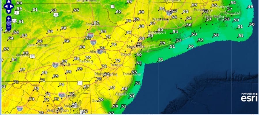
Saturday Is The Day 70 Degrees Or Better
It was a beauty of a day with cloud free conditions across our area and up and down the Northeast & Middle Atlantic states. Temperatures struggled again on a north winds with highs just in the 40s. There isn’t much happening across much of the US other than out west where we have storminess with rain coming ashore and heavy snow in the Sierra Nevada mountains measured in feet. Other than that the weather is mostly quiet in the Eastern US. Skies will be clear tonight with most lows in the 20s to lower 30s. Nothing on the radar to worry about and we may not see much of anything until later Saturday night or on Sunday with the next cold front. There is a small chance for a shower late Thursday night into Friday morning with a warm front to our north, otherwise that’s it for the work week.
SATELLITE

REGIONAL RADAR

The next 2 days it is all about wind direction. Wednesday winds will be northeast to east to southeast as the day wears on which keeps it chilly again with highs mostly in the 40s except well inland in New Jersey and the Hudson Valley east of the Hudson River where temperatures could reach into the lower 50s. Thursday will be 40s along the coast and mid to upper 50s inland. Sunshine will dominate both days with some late day clouds on Thursday. Friday with a southwest wind we should see 60s setting us up for Saturday.
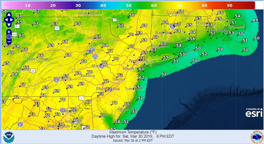
Saturday with southwest winds and a warm air mass over head, as long as we see a fair amount of sun highs will reach the 70s away from the ocean. Even coastal areas should reach into the 60s. Then the next important cold front arrives on Sunday with the chance for showers.
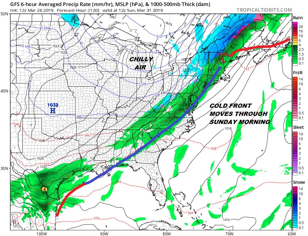
We still haven’t resolved the timing on this front for Sunday with the faster slightly flatter GFS bringing the front through faster with some showers early Sunday morning followed by slow improvement in the afternoon. The European model has a stronger low further northwest and the cold front doesn’t get through here until later in the day. That would mean clouds and showers for Sunday. Regardless next Monday and Tuesday will be chilly but a flow across the US from the Pacific promises a warmer weather pattern settling in overall.
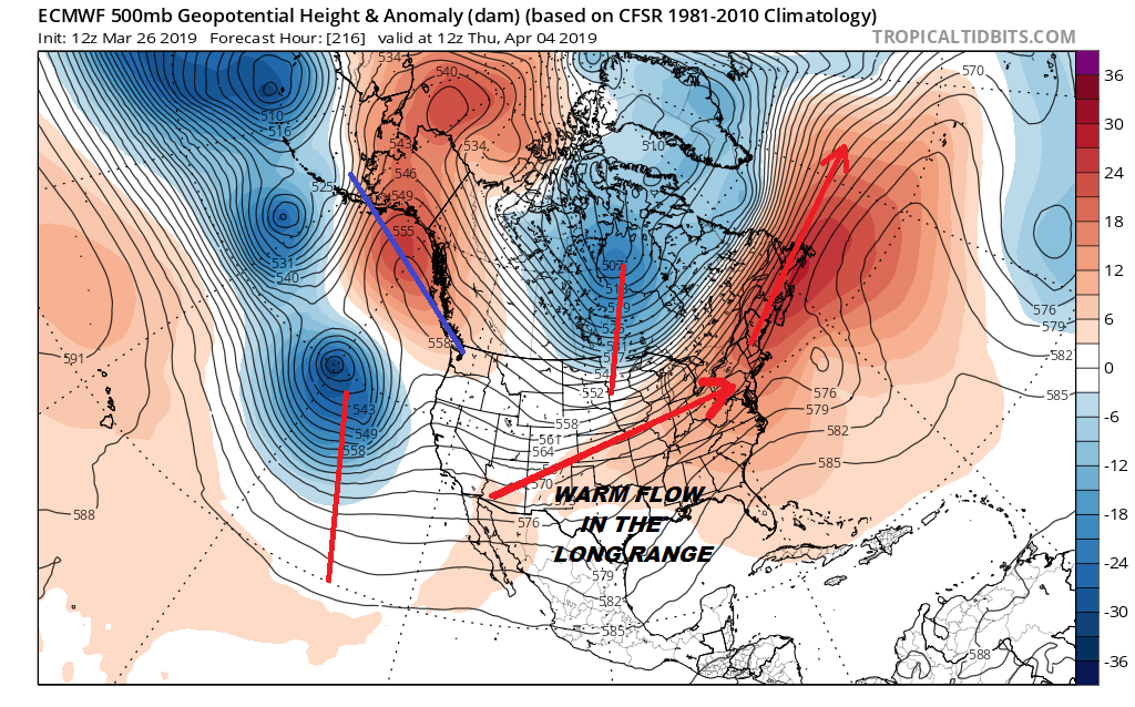
The long range climate models suggest a warmer than average April for the Eastern US which might be nice for a change. All signs continue to point to a spring which actually looks like spring.
MANY THANKS TO TROPICAL TIDBITS FOR THE USE OF MAPS
Please note that with regards to any tropical storms or hurricanes, should a storm be threatening, please consult your local National Weather Service office or your local government officials about what action you should be taking to protect life and property.


