Sandwiched Between 2 Storms Another Inch of Rain Forecast
Wednesday Night & Thursday

Sandwiched Between 2 Storms Another Inch of Rain Forecast
Wednesday Night & Thursday
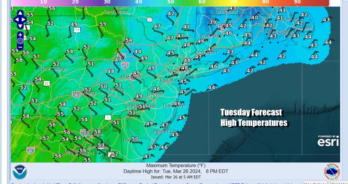
Springtime in the Northeast and Northern Mid Atlantic states is probably the worst season of the year thanks to a cold ocean and the appearance from time to time of the dreaded onshore flow. When it is being driven by high pressure sandwiched between 2 storm systems, it is just a matter of time before ocean low clouds come in from the east and that is what has happened overnight. This is going to leave is much of Eastern Pennsylvania to Southern New England in a cloudy day. Some areas far enough inland could see some breaks of sun through the clouds but overall there will be a sense of gloom and doom. The satellite loops show the ocean storm east of the North Carolina coast. To the west we have high clouds streaming northeastward ahead of a cold front and the blow off from some thunderstorms heading toward the Appalachians. Temperatures today will be mostly in the 40s to at best around 50.
SATELLITE WITH LIGHTNING STRIKES

WEATHER RADAR

The ocean storm will move south and weaken and that finally allows a cold front to the west to make some eastward progress though that front will slow down and stall out as it reaches the coast during the day Wednesday. There may not be much in the way of shower activity as the front initially arrives however a wave develops on this front in South Carolina and tracks northeastward Wednesday night and Thursday.

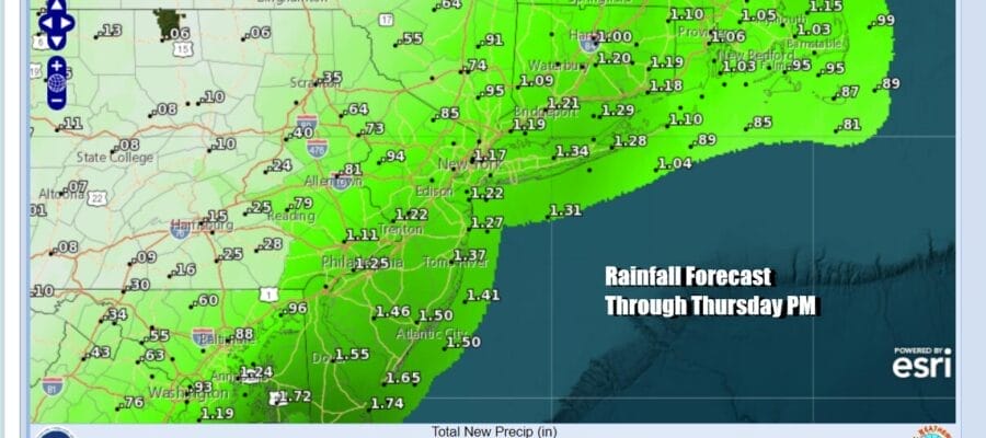
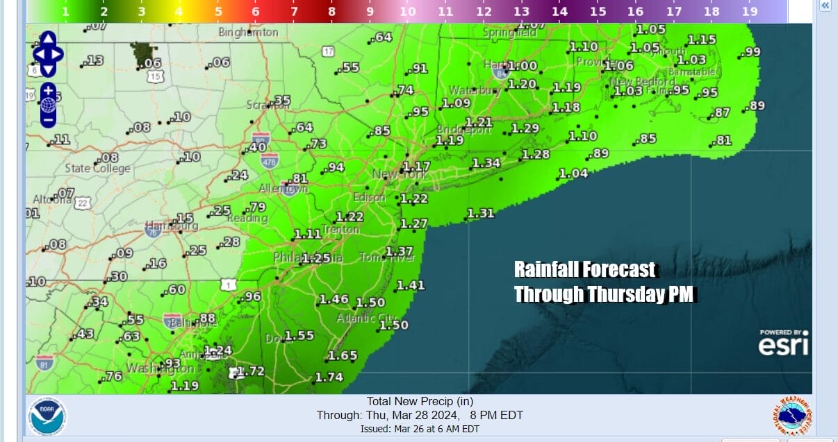
What saves us from another big clobbering of rain is that the storm system makes a push out to the east before turning northward to the Gulf of Maine. This doesn’t look like another round of 3 to 4 inch rainfalls but we will see rain develop Wednesday night from south to north and there will be some heavy rain come Thursday morning in a narrow band across New Jersey to Southern New England. As the day wears on the front nudges eastward and rain should end byduring the evening hours from west to east

Wednesday will be a day of cloudy skies with some light rain or drizzle early on but much of the day we probably won’t see much in the way of precipitation. Temperatures will be reaching into the 50s as winds turn more southeast. Then we get into the rain Wednesday night into Thursday. Thursday temperatures will be in the 50s until winds shift around to the northeast and north with the low offshore. Then temperatures will likely ease into the 40s. Rainfall amounts from this system will not be in the 3 to 4 inch range like we saw last Saturday. Right now i continue to favor a zone of 3/4 inch to 1.25 inches from west to east. That seems to make the most sense at this point.
We should see improving weather conditions during the day Friday. as high pressure builds south from Eastern Canada. Some sunshine will return with temperatures reaching the upper 40s and lower 50s. The Easter holiday weekend will feature a weak weather system and cold front coming through Saturday so we could see a mix of sun and clouds Saturday with the chance for a passing scattered shower. As long as the front stays on the weak side this should not be a big deal. That should be followed a by chilly but dry Easter Sunday with sunshine and highs in the upper 40s and lower 50s.
LOAD THE FREE METEOROLOGIST JOE CIOFFI WEATHER APP &
ANGRY BEN’S FREE WEATHER APP “THE ANGRY WEATHERMAN!
MANY THANKS TO TROPICAL TIDBITS FOR THE USE OF MAPS
Please note that with regards to any severe weather, tropical storms, or hurricanes, should a storm be threatening, please consult your local National Weather Service office or your local government officials about what action you should be taking to protect life and property.
(Amazon is an affilate of Meteorologist Joe Cioffi & earns commissions on sales.)


